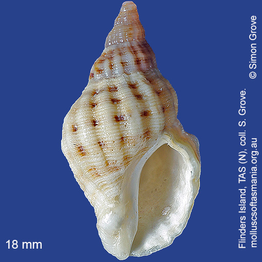
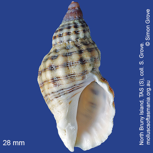
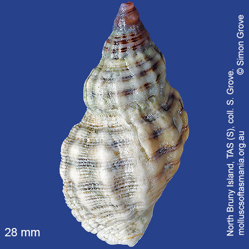
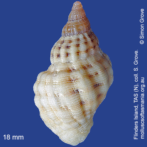
Muricidae – Rapaninae: Agnewia tritoniformis (Blainville, 1832) (‘triton-like rock-shell’)
Synonym(s): tritoniformis Blainville, 1832 typica Dunker, 1856 levidensis Kesteven, 1902 nautica Thornley, 1952.
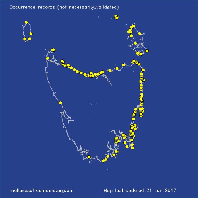
Typical shell-length 20 mm. Lives intertidally amongst rocks and seaweed, especially in moderately exposed environments. Native. Occurs in southeastern Australia (NSW, TAS and VIC); also New Zealand. In Tasmanian waters, this species is widespread and common as a beached shell.
Classification
Class: Gastropoda
Subclass: Caenogastropoda – Sorbeoconcha
Order: Hypsogastropoda – Neogastropoda
Superfamily: Muricoidea
Family: Muricidae
Subfamily: Rapaninae
Genus: Agnewia tritoniformis
A-L Localities for Agnewia tritoniformis
Bangor: Lagoon Bay
Bangor: Two Mile Beach
Bay of Fires: Break Yoke Beach to Pebbly Beach
Beaumaris: Shelly Point
Beerbarrel Beach
Bicheno
Bicheno: Cod Rock
Bicheno: Courland Bay
Bicheno: Diamond Island
Bicheno: Redbill Beach
Bicheno: Rice Beach
Bicheno: Waubs Beach
Binalong Bay
Binalong Bay: Dora Point
Binalong Bay: gulches
Blackman Bay: Little Chinaman Bay
Blackmans Bay
Black River Beach: northern end
Boat Harbour: beach
Boltons Beach
Bridport: East Sandy Point
Burnie: Blythe Heads & estuary
Cape Barren Island: Tinkers Gut
Cape Portland: Lanoma Point
Cape Portland: Lemons Beach
Cape Portland: Petal Point
Cape Portland: Roses Bay
Carlton Beach: Spectacle Island
Carlton: Park Beach
Chain of Lagoons: Four Mile Creek: beach
Chain of Lagoons: Piccaninny Point
Clarke Island: Black Point
Clarke Island: Black Point – beach to S
Clarke Island: Dip Point to Black Rocks
Clarke Island: Maclaines Bay
Clayton: foreshore
Coles Bay: Bluestone Bay
Coles Bay: foreshore
Coles Bay: Gravelly Beach & Sleepy Bay
Coles Bay: Honeymoon Bay
Coles Bay: Muirs Beach
Coles Bay (unlocalised)
Cooee Beach
Croppies Point
Denison Beach: Porch Rocks
Denison Beach: rocks at southern end
Denison Beach (unlocalised)
Devonport: Bluff Beach
Devonport: Coles Beach
Devonport: Mersey River
Douglas River: beach
Eaglehawk Neck: eastern side
Earlham: foreshore
East Devonport: Pardoe Beach
East Devonport: Pardoe Point
East Ulverstone
Eddystone Point: Picnic Corner
Eddystone Point (unlocalised)
Falmouth: foreshore
Falmouth: Mariposa Beach
Flinders Island: Killiecrankie Bay (unlocalised)
Flinders Island: Killiecrankie: foreshore
Flinders Island: Leeka: foreshore towards Twelve Hour Point
Flinders Island: Northeast River: mouth
Flinders Island: Palana Beach
Flinders Island: Patriarch Inlet
Flinders Island: Port Davies & Cave Beach
Flinders Island: Tanners Bay
Flinders Island: Tanners Bay: Pine Scrub
Flinders Island: The Dock
Flinders Island: Trousers Point: beach
Flinders Island (unlocalised)
Fortescue Bay
Frederick Henry Bay: Sloping Island
Freycinet Peninsula: Bryans Beach
Freycinet Peninsula (unlocalised)
Friendly Beaches
Georges Bay: Blanche Point
Georges Bay: Burns Bay
Georges Bay: St Helens (unlocalised)
Georges Bay (unlocalised)
Goat Island: foreshore of island and nearby mainland
Great Musselroe Bay
Greens Beach: main beach
Greens Beach: Nudists Beach
Hawley Beach: foreshore towards Point Sorell
Hellyer Beach
King Island: Cape Wickham: foreshore to E
King Island: Fitzmaurice Bay
King Island: Grassy Harbour
King Island: Naracoopa: foreshore
Kingston Beach
Leith: foreshore
Leven River: mouth
Lime Bay: Green Head
Little Musselroe Bay: northern end
Little Musselroe Bay: Tree Point area
Little Peggs Beach
Little Swanport: mouth
Little Swanport: Saltworks Beach
Low Head (unlocalised)
Lulworth: Tam O”Shanter Bay
M-Z Localities for Agnewia tritoniformis
Maria Island: Bloodstone Point
Maria Island: Darlington Bay
Maria Island: Gulls Nest Point
Maria Island: Hopground Beach
Maria Island: Howells Point & Painted Cliffs
Maria Island: Return Point
Maria Island: Trigonia Corner
Marion Bay: northern beaches
Mayfield Beach to Mayfield Point
Mayfield Point to Little Christmas Island
Musselroe Point
Narawntapu: Copper Cove
Narawntapu: Griffiths Point
North Bruny Island: Dennes Point
North Bruny Island: Nebraska Beach
Nubeena: Roaring Beach
Orford: Emerald Beach
Penguin: Lonah & Lodders Point
Pirates Bay (unlocalised)
Planters Beach to Fishers Point
Port Sorell (unlocalised)
Primrose Point
Primrose Sands
Rheban Beach
Rocky Cape: Burgess Cove
Rocky Cape: Castle Rock Bay
Rocky Cape: Cave Bay
Rocky Cape: foreshore N of Picnic Beach
Rocky Cape: Picnic Beach & rocks to S
Schouten Island: Crocketts Bay
Schouten Island: Moreys Bay
Seymour Beach: northern end
Somerset: foreshore
South Arm: Fort Beach
South Bruny Island: Adventure Bay: Cemetery Bluff
South Bruny Island: Adventure Bay: Grass Point
South Bruny Island: Cloudy Beaches: eastern beach
South Cape Bay: Lion Rock: beach to SE
South coast of Tasmania (unlocalised)
Southport Bluff: beach
Stanley: Circular Head
Stanley: Cow Rock beach
Stanley: foreshore
Stanley: Godfreys Beach
Stanley: Halfmoon Bay
Stanley: Tatlows Beach
Stanley (unlocalised)
St Helens Point
Swansea: Coswell Beach
Swansea: Jubilee Beach
Swansea: Kelvedon Beach
Swansea: Lisdillon Beach
Swansea: Spiky Beach
Swansea (unlocalised)
Swanwick: foreshore
Taroona: Alum Cliffs
Taroona Beach
Taroona: Dixons Beach
Tasmania (unlocalised)
The Gardens: beach
The Gardens: Coffeys Gulch
The Gardens: Cosy Corner
The Gardens: Mateys Gulch to Gardens Lagoon
The Gardens: Seatons Cove
The Gardens: Swimcart Beach
Three Hummock Island: Mermaid Bay
Three Hummock Island: Rape Bay
Three Hummock Island: Three Gullies Bay
Three Hummock Island: Three Gullies Bay area
Tinderbox Beach
Trial Harbour
Tunnel Bay
Ulverstone (unlocalised)
West Ulverstone: foreshore
Woolnorth: Woolnorth Point
Wynyard: Fossil Bluff