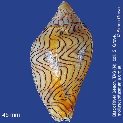
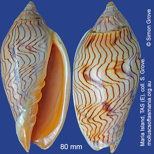
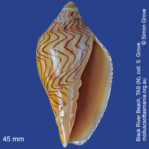
Volutidae – Amoriinae: Amoria undulata (Lamarck, 1804) (‘wavy volute’)
Synonym(s): undulata Lamarck, 1804 angasi Sowerby, 1864 sclateri Cox, 1869 kingi Cox, 1871 australiae Cox, 1872 moslemica Hedley, 1912 benthalis McMichael, 1964.
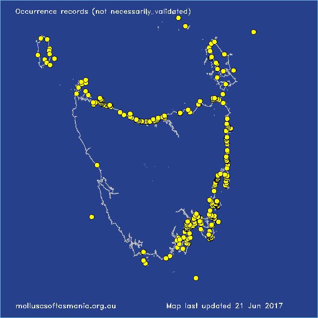
Typical shell-length 100 mm. Beached shells are often stained black or orange. Lives subtidally on sand and mud, emerging at night to feed. Native. Endemic to southern and eastern Australia (QLD, NSW, TAS, VIC and SA). In Tasmanian waters, this is a widespread and common species; often beached.
Classification
Class: Gastropoda
Subclass: Caenogastropoda – Sorbeoconcha
Order: Hypsogastropoda – Neogastropoda
Superfamily: Muricoidea
Family: Volutidae
Subfamily: Amoriinae
Genus: Amoria
A-L Localities for Amoria undulata
Bangor: Lagoon Bay
Bangor: Tasman Bay
Bangor: Two Mile Beach
Bay of Fires: Break Yoke Beach to Pebbly Beach
Beaumaris: Shelly Point
Beerbarrel Beach
Bellingham
Bicheno
Bicheno: Courland Bay
Bicheno: Diamond Island
Bicheno: Redbill Beach
Bicheno: Waubs Beach
Binalong Bay: gulches
Blackman Bay: Little Chinaman Bay
Blackmans Bay
Black River Beach
Black River Beach: northern end
Black River Beach: southern end
Boltons Beach
Bridport: beach
Bridport: East Sandy Point
Bridport (unlocalised)
Bruny Island: E coast (unlocalised)
Bruny Island: Neck Beach
Bruny Island (unlocalised)
Burnie: Blythe Heads & estuary
Burnie: Sulphur Creek
Calverts Beach & Goats Bluff
Cape Barren Island (unlocalised)
Cape Portland: Home Beach
Cape Portland: Lanoma Point
Cape Portland: Lemons Beach
Cape Portland: Petal Point
Cape Portland: Roses Bay
Cape Portland (unlocalised)
Carlton Beach: Spectacle Island
Carlton: Park Beach
Chain of Lagoons
Chain of Lagoons: Four Mile Creek: beach
Chain of Lagoons: Piccaninny Point
Clarke Island: Kangaroo Bay to Seal Point
Clayton: foreshore
Clifton Beach (unlocalised)
Clifton Beach: western end
Coles Bay: Honeymoon Bay
Coles Bay: Richardsons Beach
Cox Bight (unlocalised)
Cremorne: foreshore
Croppies Beach: northern end
Croppies Point
Denison Beach: Porch Rocks
Denison Beach: rocks at southern end
Denison Beach (unlocalised)
D’Entrecasteaux Channel (unlocalised)
Devonport: Bluff Beach
Devonport (unlocalised)
Douglas River: beach
Dover: Roaring Bay Beach
Eaglehawk Neck: eastern side
Earlham: foreshore
East Devonport: beach & breakwater
East Devonport: Moorland Point
East Devonport: Pardoe Beach
East Devonport: Pardoe Point
East Ulverstone
Falmouth: foreshore
Falmouth: Mariposa Beach
Flinders Island: Emita: foreshore
Flinders Island: Fotheringate Beach: southern end
Flinders Island: Lady Barron: Watering Beach
Flinders Island: Lillies Bay
Flinders Island: Northeast River: mouth
Flinders Island: Palana Beach
Flinders Island: Parrys Bay: Double Corner
Flinders Island: Patriarch Beach
Flinders Island: Port Davies & Cave Beach
Flinders Island: Tanners Bay
Flinders Island: Trousers Point
Flinders Island (unlocalised)
Flinders Island: Whitemark Beach
Frederick Henry Bay: Sloping Island
Freycinet Peninsula: Bryans Beach
Freycinet Peninsula: Cooks Beach
Freycinet Peninsula: Hazards Beach
Freycinet Peninsula (unlocalised)
Freycinet Peninsula: Wineglass Bay
Friendly Beaches
Furneaux Group (unlocalised)
Garden Island Sands
Georges Bay: Blanche Point
Georges Bay: St Helens (unlocalised)
Goat Island: foreshore of island and nearby mainland
Great Oyster Bay
Greens Beach: main beach
Hawley Beach: foreshore towards Point Sorell
Hellyer Beach
Hunter Island: Cave Bay
King Island: City of Melbourne Bay
King Island: Grassy Harbour: Sandblow Bay
King Island: Lavinia Beach: beach nr Lake Martha Lavinia
King Island: Naracoopa: foreshore
King Island: Sea Elephant Bay: Blowhole
King Island: Sea Elephant Bay: Cowper Point
King Island: Seal Bay: Black Point
King Island (unlocalised)
King Island: Yellow Rock Beach
Kingston Beach
Lauderdale: Roches Beach
Lauderdale: Seven Mile Beach
Leith: foreshore
Leith: Lillico Beach
Little Musselroe Bay: northern end
Little Musselroe Bay: Tree Point area
Little Peggs Beach
Little Swanport: Saltworks Beach
Low Head: Lagoon Beach
Low Head (unlocalised)
M-Z Localities for Amoria undulata
Maria Island: Bloodstone Beach
Maria Island: Chinamans Bay
Maria Island: Darlington Bay
Maria Island: Encampment Cove
Maria Island: Gulls Nest Point
Maria Island: Hopground Beach
Maria Island: Howells Point & Painted Cliffs
Maria Island: Oyster Bay
Maria Island: Point Lesueur
Maria Island: Return Point
Maria Island: Riedlé Bay: McRaes Isthmus
Maria Island: Shoal Bay: McRaes Isthmus
Maria Island: Trigonia Corner
Marion Bay: Bream Creek foreshore
Marion Bay: northern beaches
Marion Bay (unlocalised)
Mayfield Beach to Mayfield Point
Mayfield Point to Little Christmas Island
Musselroe Point
Narawntapu: Badger Head
Narawntapu: Bakers Beach
Narawntapu: Griffiths Point
Narawntapu: Little Badger Head
Narawntapu: Penguin Island: mainland foreshore opposite island
Nine Mile Beach & Dolphin Sands
North Bruny Island: Bull Bay
North Bruny Island: Dennes Point
North Bruny Island: Killora Bay
North Bruny Island: Miles Beach
North Bruny Island: Nebraska Beach
Nubeena: Roaring Beach
Orford: Emerald Beach
Orford: Spring Beach
Orford (unlocalised)
Peggs Beach: eastern end
Peggs Beach (unlocalised)
Peggs Beach: western end
Penguin: Lonah & Lodders Point
Pipers Head
Pirates Bay: Fossil Island
Pirates Bay (unlocalised)
Planters Beach to Fishers Point
Point Sorell and foreshore to SW
Port Arthur: Denmans Cove
Port Arthur: Stinking Bay
Port Sorell (unlocalised)
Primrose Beach to Carlton Bluff
Randalls Bay
Rheban Beach
Robbins Island: Ransonnet Bay
Rocky Cape: Burgess Cove
Rocky Cape: Castle Rock Bay
Rocky Cape: foreshore N of Picnic Beach
Rocky Cape: Forwards Beach
Rocky Cape: Mary Anne Cove area
Rocky Cape: northern coves
Rocky Cape: Picnic Beach & rocks to S
Rocky Cape (unlocalised)
Scamander (unlocalised)
Scamander: Wrinklers Beach
Schouten Island: Moreys Bay
Schouten Island: Sandspit Point
Sloping Lagoon: Lagoon Beach
Sloping Main Beach
Sloping Main: Black Jack Point
Smithton: Duck Bay: Picnic Point
Smithton: Duck River mouth
Somerset: foreshore
Sorell: Woody Island
South Arm: Fort Beach
South Arm: Hope Beach: southern end
South Arm: Pigeon Holes
South Bruny Island: Adventure Bay: Cemetery Bluff
South Bruny Island: Adventure Bay: Grass Point
South Bruny Island: Cloudy Beaches: eastern beach
South Bruny Island: Hopwood Beach
South coast of Tasmania (unlocalised)
Stanley: Anthony Beach
Stanley: Circular Head
Stanley: East Inlet
Stanley: foreshore
Stanley: Godfreys Beach
Stanley: Green Hills: West Inlet entrance
Stanley: Halfmoon Bay
Stanley: Tatlows Beach
Stanley (unlocalised)
St Helens Point
Swansea: Coswell Beach
Swansea: Cressy Beach
Swansea: Jubilee Beach
Swansea: Kelvedon Beach
Swansea: Kelvedon Beach: Shelly Point
Swansea: Kennedia Beach
Swansea: Lisdillon Beach
Swansea: Spiky Beach
Swansea (unlocalised)
Swanwick: foreshore
Tamar River: Kelso: foreshore
Taroona: Alum Cliffs
Taroona Beach
Taroona: Dixons Beach
Taroona: Hinsby Beach
Tasmania (unlocalised)
The Gardens: Seatons Cove
The Gardens: Swimcart Beach
The Gardens: Taylors Beach
Three Hummock Island: Burgess Point
Three Hummock Island: East Telegraph Beach
Three Hummock Island: Mermaid Bay
Three Hummock Island: Sandy Spit
Tinderbox Beach
Tinderbox: Fossil Cove
Trial Harbour
Trial Harbour area
Turners Beach
Ulverstone (unlocalised)
Verona Sands
Walker Island
Waterhouse Island
West Ulverstone: foreshore
Weymouth: beach
Woolnorth: Woolnorth Point
Wynyard (unlocalised)