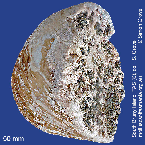
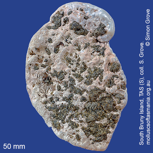
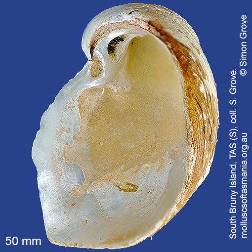
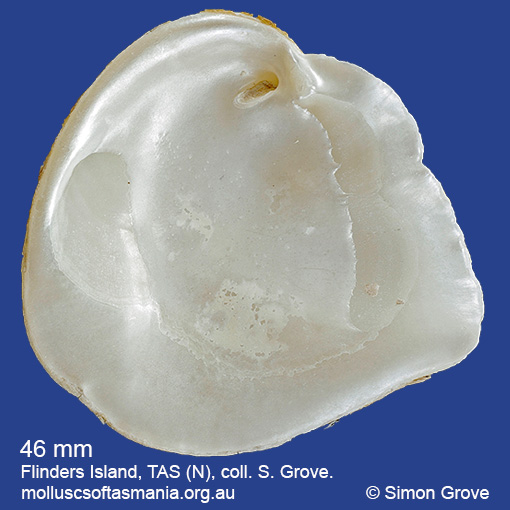
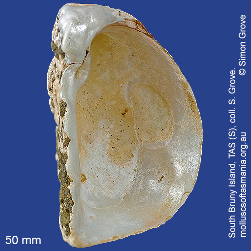
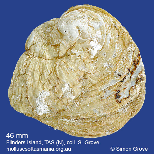
Cleidothaeridae: Cleidothaerus albidus (Lamarck, 1819) (‘white rock-clam’)
Synonym(s): albidus Lamarck, 1819 chamoides Stutchbury, 1830.
Typical shell-length 75 mm. One valve is flattened, the other inflated. Lives subtidally attached to rocks and shells by its right valve, in exposed environments. Native. Occurs in southeastern Australia (NSW, TAS, VIC and SA); also New Zealand. In Tasmanian waters, this is a widespread species, but not commonly beached.
Classification
Class: Bivalvia
Subclass: Heterodonta
Order: Pholadomyoida
Superfamily: Pandoroidea
Family: Cleidothaeridae
Genus: Cleidothaerus
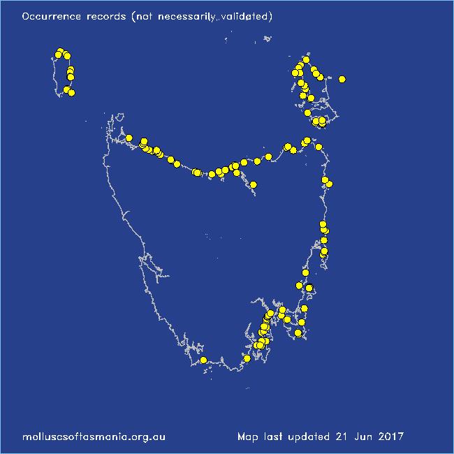
Localities for Cleidothaerus albidus
Beechford: foreshore
Beerbarrel Beach
Bicheno: Waubs Gulch
Blackmans Bay
Black River Beach: southern end
Boltons Beach
Bridport: East Sandy Point
Bruny Island: Isthmus Bay
Cape Barren Island: Bungs Beach
Cape Portland: Petal Point
Cape Portland: Roses Bay
Carlton Beach: Spectacle Island
Clarke Island: Black Point
Clarke Island: Black Point – beach to N
Clarke Island: Dip Point to Black Rocks
Clarke Island: Kangaroo Bay to Seal Point
Coles Bay: Honeymoon Bay
Coles Bay (unlocalised)
Coningham: foreshore
Denison Beach: Porch Rocks
Denison Beach: rocks at southern end
D’Entrecasteaux Channel (unlocalised)
Derwent Estuary (unlocalised)
East Devonport: Pardoe Beach
East Devonport: Pardoe Beach: The Water Rat
East Kangaroo Island (unlocalised)
East Ulverstone
Flinders Island: Arthur Bay: Long Point
Flinders Island: Foochow Beach
Flinders Island: Foochow Inlet
Flinders Island: Fotheringate Bay
Flinders Island: Killiecrankie Bay (unlocalised)
Flinders Island: Killiecrankie: foreshore
Flinders Island: Leeka: foreshore towards Twelve Hour Point
Flinders Island: Lillies Bay
Flinders Island: Northeast River: mouth
Flinders Island: Patriarch Beach
Flinders Island: Patriarch Inlet
Flinders Island: Tanners Bay
Flinders Island: The Dock
Flinders Island: Trousers Point
Freycinet Peninsula (unlocalised)
Friendly Beaches
Goat Island: foreshore of island and nearby mainland
Greens Beach: main beach
Hellyer Beach
Herbies Landing
King Island: Boulder Point
King Island: Cape Wickham: foreshore to E
King Island: E coast (unlocalised)
King Island: Grassy
King Island: Grassy Harbour: Sandblow Bay
King Island: Lavinia Beach: beach nr Lake Martha Lavinia
King Island: Naracoopa: foreshore
King Island: Sea Elephant Bay: Blowhole
King Island: Sea Elephant Bay: Cowper Point
King Island: Seal Bay: Black Point
King Island: Yellow Rock Beach
Kingston Beach
Low Head: East Beach
Low Head: Lagoon Beach
Low Head (unlocalised)
Maria Island: Darlington Bay
Maria Island: Hopground Beach
Maria Island: Howells Point & Painted Cliffs
Musselroe Point
Narawntapu: Copper Cove
Narawntapu: Little Badger Head
North Bruny Island: Killora Bay
Orford: Millingtons Beach
Pipers Head
Pirates Bay (unlocalised)
Port Arthur (unlocalised)
Port Latta: Cowrie Point
Port Sorell (unlocalised)
Robbins Island: East Beach
Rocky Cape: Castle Rock Bay
Rocky Cape: foreshore N of Picnic Beach
Rocky Cape: Forwards Beach
Rocky Cape: Mary Anne Cove area
Rocky Cape: Picnic Beach & rocks to S
Sisters Beach
Sloping Main Beach
Sloping Main: Black Jack Point
Somerset: foreshore
South Bruny Island: Alonnah: Sunset Bay
Southport Bluff: beach
Stanley: Cow Rock beach
Stanley: Green Hills: West Inlet entrance
Stanley: Tatlows Beach
Tamar River: Beauty Point: Inspection Head area
Tamar River: Kelso: foreshore
Taroona: Alum Cliffs
Taroona Beach
Taroona: Dixons Beach
Tasmania (unlocalised)
The Gardens: Swimcart Beach
Tomahawk Beach
Ulverstone (unlocalised)
Waterhouse Point
West Ulverstone: foreshore
West Ulverstone: Picnic Point: beach to W
Woodbridge: foreshore & Birchs Point
Wynyard: Fossil Bluff
Wynyard (unlocalised)