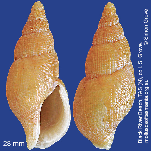
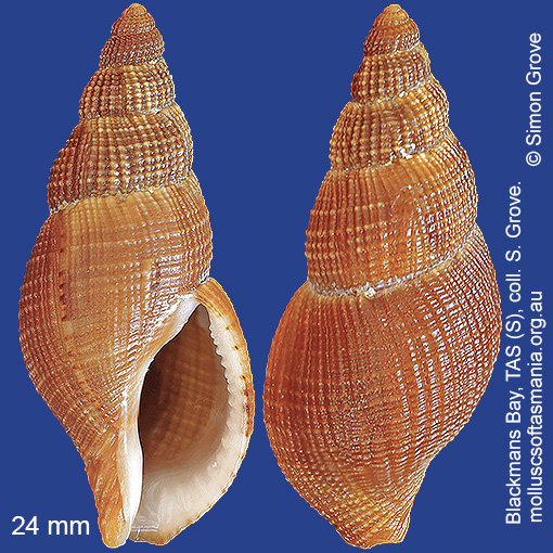
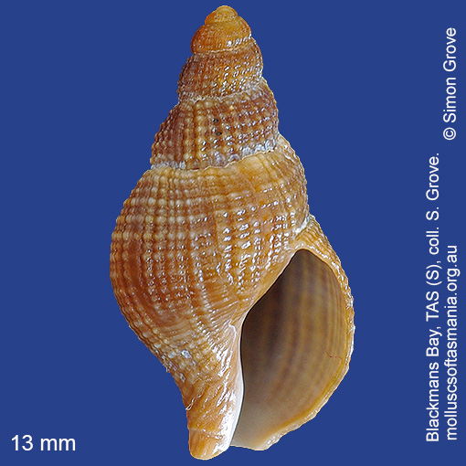
Colubrariidae: Cumia mestayerae (Iredale, 1915) (‘Mestayer’s whelk’)
Synonym(s): mestayerae Iredale, 1915 reticulatus A. Adams, 1855.
Typical shell-length 35 mm. Lives subtidally amongst rocks and seaweed, especially in exposed environments. Native. Occurs in southeastern and southwestern Australia (NSW, TAS, VIC, SA and WA); also New Zealand. In Tasmanian waters, this is a widespread but uncommon species.
Classification
Class: Gastropoda
Subclass: Caenogastropoda – Sorbeoconcha
Order: Hypsogastropoda – Neogastropoda
Superfamily: Buccinoidea
Family: Colubrariidae
Genus: Cumia
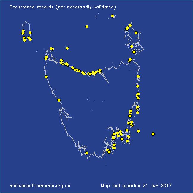
Localities for Cumia mestayerae
Bicheno: Diamond Island
Bicheno: Rice Beach
Bicheno: Waubs Beach
Blackmans Bay
Black River Beach: northern end
Black River Beach: southern end
Boltons Beach
Bruny Island (unlocalised)
Burnie: Blythe Heads & estuary
Burnie (unlocalised)
Cape Portland: Home Beach
Cape Portland: Lanoma Point
Cape Portland: Petal Point
Carlton Beach: Spectacle Island
Carlton: Park Beach
Clarke Island: Dip Point to Black Rocks
Clifton Beach: western end
Coles Bay: Honeymoon Bay
Denison Beach: Porch Rocks
Devonport: Bluff Beach
Eaglehawk Neck: eastern side
East Devonport: Moorland Beach
East Devonport: Pardoe Beach
East Devonport: Pardoe Point
East Ulverstone
East Ulverstone: Buttons Beach
Falmouth: Mariposa Beach
Flinders Island: Killiecrankie: foreshore
Flinders Island: Northeast River: mouth
Flinders Island: Patriarch Beach
Flinders Island: The Dock
Frederick Henry Bay: Sloping Island
Freycinet Peninsula: Hazards Beach
Freycinet Peninsula: The Hazards
Freycinet Peninsula (unlocalised)
Greens Beach: main beach
Hawley Beach: foreshore towards Point Sorell
King Island: Currie Harbour
King Island: Fitzmaurice Bay
King Island: Foreshore S of Currie
King Island: Grassy Harbour
King Island: Little Porky Beach
King Island: Naracoopa: foreshore
King Island: Seal Bay: Black Point
King Island: Surprise Bay
King Island (unlocalised)
Lauderdale: Roches Beach
Little Swanport: Saltworks Beach
Long Island: Crayfish Point
Low Head (unlocalised)
Maria Island: Darlington Bay
Maria Island: Gulls Nest Point
Maria Island: Hopground Beach
Maria Island: Shoal Bay: McRaes Isthmus
Maria Island: Trigonia Corner
Marion Bay: Bream Creek foreshore
Marion Bay (unlocalised)
Mayfield Beach to Mayfield Point
Narawntapu: Bakers Point & Springlawn Beach
Narawntapu: Griffiths Point
Narawntapu: Little Badger Head
North Bruny Island: Dennes Point
Nubeena: Roaring Beach
Orford: Emerald Beach
Peggs Beach: eastern end
Peggs Beach (unlocalised)
Penguin: Lonah & Lodders Point
Pirates Bay: near landing
Port Arthur: Denmans Cove
Port Latta: Cowrie Point
Rocky Cape: Anniversary Bay
Rocky Cape: Castle Rock Bay
Rocky Cape: Forwards Beach
Rocky Cape: Mary Anne Cove area
Rocky Cape: Picnic Beach & rocks to S
Schouten Island: Crocketts Bay
Seymour Beach: northern end
Shearwater: Freers Beach
Somerset: foreshore
South Bruny Island: Adventure Bay: Cemetery Bluff
South Bruny Island: Adventure Bay – Coal Point
South Bruny Island: Adventure Bay: Grass Point
South Bruny Island: Butlers Beach
South Bruny Island: Hopwood Beach
South Bruny Island: Old Jetty Beach
South East coast of Tasmania (unlocalised)
Stanley: Circular Head
Stanley: foreshore
Stanley: Godfreys Beach
Tamar River: Kelso: foreshore
Taroona: Alum Cliffs
Taroona Beach
Taroona: Dixons Beach
Tasmania (unlocalised)
Temma
The Gardens: Swimcart Beach
Three Hummock Island: Rape Bay
Three Hummock Island: Three Gullies Bay
Tinderbox Beach
Trial Harbour area
Ulverstone (unlocalised)
West Ulverstone: foreshore
Woolnorth: Valley Bay
Woolnorth: Woolnorth Point
Wynyard: Fossil Bluff
Wynyard (unlocalised)