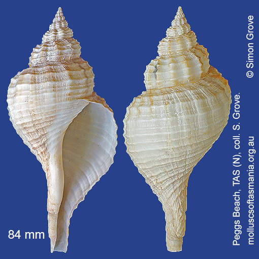
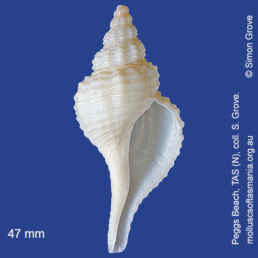
Fasciolariidae – Fusininae: Fusinus (Propefusus) pyrulatus (Gmelin, 1791) (‘wavy spindle-shell’)
Synonym(s): undulatus Perry, 1811 pyrulatus Reeve, 1847 ustulatus Reeve, 1847 legrandi Tenison-Woods, 1876 profundior Cotton & Godfrey, 1932 compositis Maybloom, 1951.
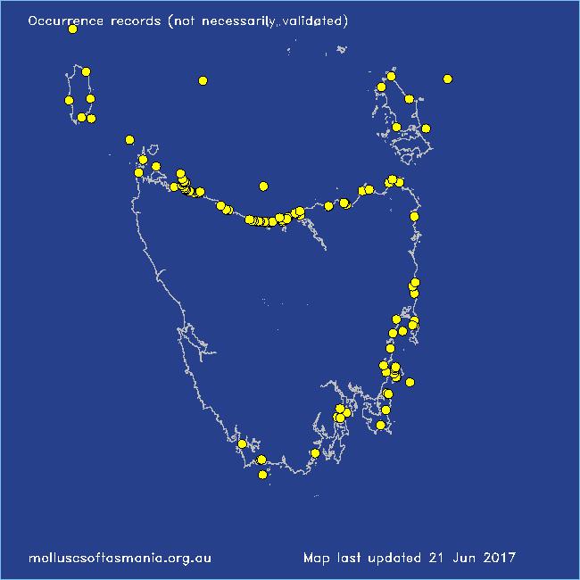
Typical shell-length 100 mm. Lives subtidally and offshore on sand and mud. Native. Endemic to southeastern and southwestern Australia (NSW, TAS, VIC, SA and WA). In Tasmanian waters, this is a common species in the N, where the largest shells are found; rare or absent to the S.
Classification
Class: Gastropoda
Subclass: Caenogastropoda – Sorbeoconcha
Order: Hypsogastropoda – Neogastropoda
Superfamily: Buccinoidea
Family: Fasciolariidae
Subfamily: Fusininae
Genus: Fusinus
Localities for Fusinus pyrulatus
Bay of Fires: Break Yoke Beach to Pebbly Beach
Bellingham
Bicheno: Diamond Island
Black River Beach
Black River Beach: northern end
Black River Beach: southern end
Boltons Beach
Bridport: Adams Beach
Bridport: Lades Beach
Bridport (unlocalised)
Cape Portland: Petal Point
Cape Portland: Roses Bay
Clayton: foreshore
Coles Bay: foreshore
Coles Bay (unlocalised)
Coningham Beach
Cooee Beach
Cox Bight (unlocalised)
Croppies Beach: northern end
Denison Beach: Porch Rocks
Devonport: Bluff Beach
Devonport: Don Heads
Devonport (unlocalised)
Eaglehawk Neck: eastern side
East Devonport: beach & breakwater
East Devonport: Moorland Beach
East Devonport: Pardoe Beach
East Devonport: Pardoe Point
East Ulverstone
East Ulverstone: Buttons Beach
Flinders Island: Northeast River: mouth
Flinders Island: Patriarch Beach
Flinders Island: Trousers Point: beach
Flinders Island (unlocalised)
Freycinet Peninsula (unlocalised)
Freycinet Peninsula: Wineglass Bay
Goat Island: foreshore of island and nearby mainland
Greens Beach: main beach
Greens Beach: Nudists Beach
Hawley Beach: foreshore towards Point Sorell
Hellyer Beach
Hunter Island (unlocalised)
King Island: Currie Harbour
King Island: Lavinia Beach: beach nr Lake Martha Lavinia
King Island: Naracoopa: foreshore
King Island: Red Hut Point
King Island: Seal Bay: Black Point
King Island (unlocalised)
Leith: foreshore
Leith: Lillico Beach
Little Musselroe Bay: Tree Point area
Little Peggs Beach
Low Head (unlocalised)
Maatsuyker Island
Maria Island: Bloodstone Beach
Maria Island: Coxswain Creek: foreshore
Maria Island: Darlington Bay
Maria Island: Howells Point & Painted Cliffs
Maria Island: Shoal Bay: McRaes Isthmus
Maria Island: Trigonia Corner
Mayfield Beach to Mayfield Point
Narawntapu: Bakers Beach
Narawntapu: Copper Cove
Narawntapu: Griffiths Point
Narawntapu: Little Badger Head
North Bruny Island: Killora Bay
North coast of Tasmania (unlocalised)
Orford: Shelly Beach (unlocalised)
Peggs Beach: eastern end
Peggs Beach (unlocalised)
Peggs Beach: western end
Pipers Head
Point Sorell and foreshore to SW
Port Arthur (unlocalised)
Port Davey: Schooner Cove
Port Latta: Cowrie Point
Ransons Beach
Rheban Beach
Rocky Cape: foreshore N of Picnic Beach
Rocky Cape: Forwards Beach
Rocky Cape: Mary Anne Cove area
Rocky Cape: Picnic Beach & rocks to S
Rocky Cape (unlocalised)
Seymour Beach: northern end
Somerset: foreshore
South Arm: Fort Beach
South East coast of Tasmania (unlocalised)
Southport: Roaring Beach
Stanley: Anthony Beach
Stanley: foreshore
Stanley: Godfreys Beach
Stanley: Green Hills: West Inlet entrance
Stanley: Halfmoon Bay
Stanley: Tatlows Beach
Stanley (unlocalised)
Swansea: Meredith River: mouth
Tamar River: Kelso: foreshore
Tasmania (unlocalised)
Turners Beach
Walker Island
West Ulverstone: foreshore
Woolnorth: Davisons Bay