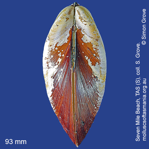
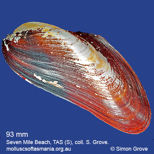
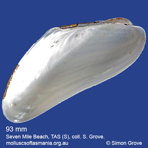
Mytilidae: Gibbomodiola albicosta (Lamarck, 1819) (‘white-sided horse-mussel’)
Synonym(s): albicosta Lamarck, 1819 delinifica Iredale, 1924.
Typical shell-length 130 mm. Periostracum bristly; flakes off when worn. Interior of shell pearly-white. Lives subtidally embedded in sponges in exposed environments. Native. Endemic to southeastern and southwestern Australia (QLD, NSW, TAS, VIC, SA and WA). In Tasmanian waters, this is a widespread and common species.
Classification
Class: Bivalvia
Subclass: Pteriomorphia
Order: Mytiloida
Superfamily: Mytiloidea
Family: Mytilidae
Genus: Gibbomodiola
A-L Localities for Gibbomodiola albicosta
Bangor: Lagoon Bay
Bangor: Tasman Bay
Bangor: Two Mile Beach
Beaumaris Beach
Beaumaris: Shelly Point
Bicheno: Redbill Beach
Blackmans Bay
Black River Beach
Black River Beach: northern end
Black River Beach: southern end
Boltons Beach
Bridport: Adams Beach
Bridport: beach
Bridport: East Sandy Point
Bridport: St Albans Bay
Bridport (unlocalised)
Bruny Island: Neck Beach
Bruny Island (unlocalised)
Burnie: Sulphur Creek
Calverts Beach & Goats Bluff
Cape Portland (unlocalised)
Carlton: Park Beach
Chain of Lagoons
Chain of Lagoons: Four Mile Creek: beach
Chain of Lagoons: Little Beach
Chain of Lagoons: McIntyres Beach
Chain of Lagoons: Piccaninny Point
Clifton Beach: eastern end
Clifton Beach (unlocalised)
Clifton Beach: western end
Coles Bay: Parsons Cove
Coles Bay: Richardsons Beach
Cremorne: foreshore
Croppies Beach: northern end
Croppies Point
Denison Beach (unlocalised)
Derwent channel
Dianas Beach (unlocalised)
Dover: beach
Eaglehawk Neck: eastern side
Earlham: foreshore
East Devonport: Moorland Beach
E coast of Tasmania (unlocalised)
Eddystone Point: Purdon Bay
Falmouth: foreshore
Falmouth: Mariposa Beach
Flinders Island: Northeast River: mouth
Flinders Island: Palana Beach
Flinders Island: Patriarch Beach
Flinders Island: Tanners Bay
Flinders Island: Trousers Point: beach
Fortescue Bay
Freycinet Peninsula: Bryans Beach
Freycinet Peninsula: Cooks Beach
Freycinet Peninsula: Hazards Beach
Freycinet Peninsula (unlocalised)
Freycinet Peninsula: Wineglass Bay
Georges Bay: Blanche Point
Georges Bay (unlocalised)
Great Musselroe Bay
Great Oyster Bay
Greens Beach: main beach
Greens Beach: Nudists Beach
Hawley Beach: foreshore towards Point Sorell
Herbies Landing
Howden: foreshore
Howrah Beach
King Island: Colliers Beach
King Island: Currie Harbour
King Island: Lavinia Beach: beach nr Lake Martha Lavinia
King Island: Naracoopa: foreshore
King Island: Sea Elephant Bay: Cowper Point
King Island (unlocalised)
King Island: Yellow Rock Beach
Kingston Beach
Lauderdale: Roches Beach
Lauderdale: Seven Mile Beach
Little Musselroe Bay: Tree Point area
Little Swanport: Saltworks Beach
M-Z Localities for Gibbomodiola albicosta
Maria Island: Bloodstone Beach
Maria Island: Darlington Bay
Maria Island: Four Mile Beach
Maria Island: Hopground Beach
Maria Island: Howells Point & Painted Cliffs
Maria Island: Trigonia Corner
Marion Bay: Bream Creek foreshore
Marion Bay: northern beaches
Marion Bay (unlocalised)
Marrawah: Green Point Beach
Mayfield Beach to Mayfield Point
Narawntapu: Badger Beach
Narawntapu: Badger Head
Narawntapu: Bakers Beach
Narawntapu: Bakers Point & Springlawn Beach
Narawntapu: Griffiths Point
Narawntapu: Little Badger Head
Nine Mile Beach & Dolphin Sands
North Bruny Island: Bull Bay
North Bruny Island: Miles Beach
North Bruny Island (unlocalised)
Okehampton Bay (unlocalised)
Orford: Millingtons Beach
Orford: Raspins Beach
Orford: Spring Beach
Peggs Beach: eastern end
Peggs Beach (unlocalised)
Peggs Beach: western end
Pirates Bay (unlocalised)
Planters Beach to Fishers Point
Point Sorell: Margaret Rocks
Port Davey: Bond Bay
Port Latta: Brickmakers Beach
Port Latta: Cowrie Point
Port Sorell: beach
Port Sorell (unlocalised)
Rheban Beach
Robbins Island: Marys Island area
Robbins Island: Ransonnet Bay
Rocky Cape: foreshore N of Picnic Beach
Rocky Cape: Forwards Beach
Scamander: Steels Beach
Scamander (unlocalised)
Scamander: Wrinklers Beach
Schouten Island: Crocketts Bay
Schouten Island: Moreys Bay
Schouten Island: Sandspit Point
Seymour Beach: northern end
Shearwater: Freers Beach
Sloping Main: Black Jack Point
South Arm: Hope Beach: southern end
South Bruny Island: Adventure Bay: southern end
South Bruny Island: Adventure Bay (unlocalised)
South Bruny Island: Cloudy Beaches: eastern beach
South Bruny Island: Cloudy Beaches: western beach
South Bruny Island: Simpsons Bay
South Croppies Point
South East coast of Tasmania (unlocalised)
Southport Bluff: beach
Southport: Roaring Beach
Stanley: Anthony Beach
Stanley: Circular Head
Stanley: East Inlet
Stanley: foreshore
Stanley: Godfreys Beach
Stanley: Halfmoon Bay
Stanley: Tatlows Beach
Stanley (unlocalised)
Swansea: Coswell Beach
Swansea: Cressy Beach
Swansea: Kelvedon Beach
Swansea: Kennedia Beach
Swansea (unlocalised)
Swanwick: foreshore
Tamar River: Bell Bay: power-station jetty
Tamar River: Kelso: foreshore
Taroona: Alum Cliffs
Tasmania (unlocalised)
The Gardens: Swimcart Beach
The Gardens: Taylors Beach
Three Hummock Island: Sandy Spit
Tomahawk Beach
Turners Beach
Walker Island
Weymouth: beach