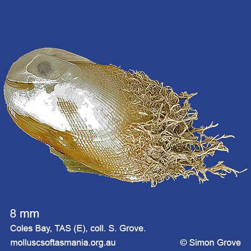
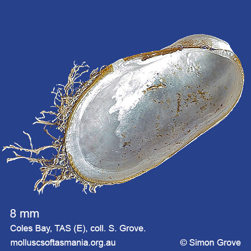
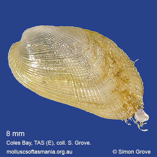
Mytilidae: Gregariella barbata (Reeve, 1858) (‘hairy mussel’)
Synonym(s): barbata Reeve, 1858.
Typical shell-length 9.0 mm. Periostracum is persistent and bears long, coarse bristles towards anterior and lateral margins. Lives subtidally in mud. Native. Occurs in southeastern Australia (NSW, TAS and VIC); also elsewhere in the western Pacific Ocean and Japan. In Tasmanian waters, this is a widespread and common species.
Classification
Class: Bivalvia
Subclass: Pteriomorphia
Order: Mytiloida
Superfamily: Mytiloidea
Family: Mytilidae
Genus: Gregariella
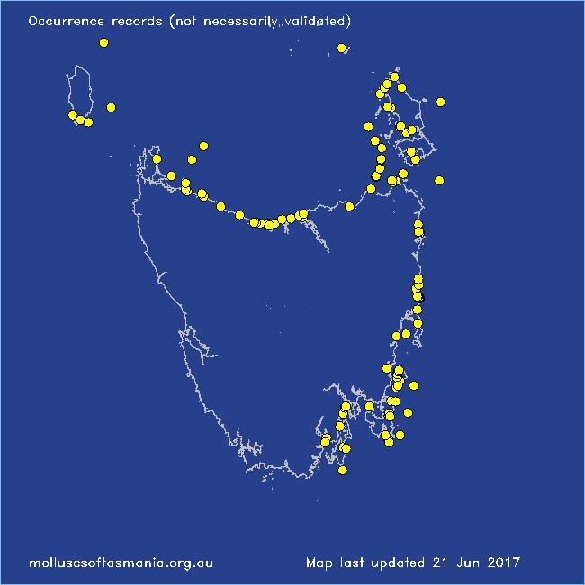
Localities for Gregariella barbata
Bangor: Lagoon Bay
Bicheno: Cod Rock
Bicheno: Redbill Beach
Bicheno: Waubs Beach
Binalong Bay: beach
Binalong Bay: Jeanneret Beach
Blackmans Bay
Black River Beach: northern end
Black River Beach: southern end
Bridport: beach
Bridport (unlocalised)
Burnie: Blythe Heads & estuary
Cape Portland: Home Beach
Cape Portland: Roses Bay
Cape Portland (unlocalised)
Chain of Lagoons: Piccaninny Point
Clarke Island: Black Point
Coles Bay: foreshore
Coles Bay: Richardsons Beach
Denison Beach: Porch Rocks
D’Entrecasteaux Channel (unlocalised)
Devonport: Coles Beach
Dover: Roaring Bay Beach
Eaglehawk Neck: eastern side
East Devonport: Moorland Beach
East Ulverstone: Buttons Beach
East Wynyard: beach
Erith Island
Flinders Island: Badger Corner
Flinders Island: E coast (unlocalised)
Flinders Island: Fotheringate Bay
Flinders Island: Fotheringate Beach: southern end
Flinders Island: Leeka: foreshore towards Twelve Hour Point
Flinders Island: Lillies Bay
Flinders Island: Northeast River: mouth
Flinders Island: Sawyers Bay
Flinders Island: The Dock
Flinders Island (unlocalised)
Franklin Sound area
Friendly Beaches
Greens Beach: main beach
Hawley Beach: foreshore towards Point Sorell
King Island: Fitzmaurice Bay
King Island: Seal Point
Leven River: mouth
Lime Bay: Green Head
Low Head: East Beach
Maria Island: Bloodstone Point
Maria Island: Darlington Bay
Maria Island: Four Mile Beach
Maria Island: Howells Point & Painted Cliffs
Maria Island: Trigonia Corner
Mayfield Beach to Mayfield Point
Narawntapu: Copper Cove
Orford: East Shelly Beach
Pirates Bay: near landing
Pirates Bay (unlocalised)
Port Cygnet: Cray Point
Rocky Cape: Castle Rock Bay
Rocky Cape: Mary Anne Cove area
Seymour Beach: northern end
South Bruny Island: Adventure Bay: Cemetery Bluff
South Bruny Island: Adventure Bay: Grass Point
Stanley: Godfreys Beach
Tamar River: Kelso: foreshore
Taroona Beach
Taroona: Dixons Beach
The Gardens: Coffeys Gulch
The Gardens: Swimcart Beach
Turners Beach
Waterhouse Point
West Devonport: Berth 3