Mangeliidae: Guraleus (Guraleus) pictus (A. Adams & Angas, 1864) (‘painted turrid’)
Synonym(s): pictus Adams & Angas, 1863 lineata Angas, 1865 vincentinus Crosse & Fischer, 1865 meredithiae Tenison-Woods, 1876.
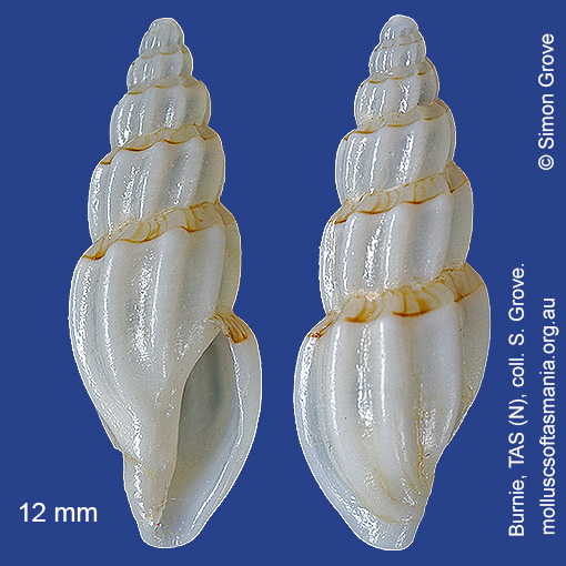
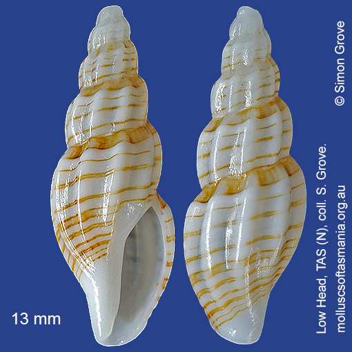
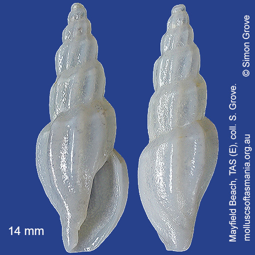
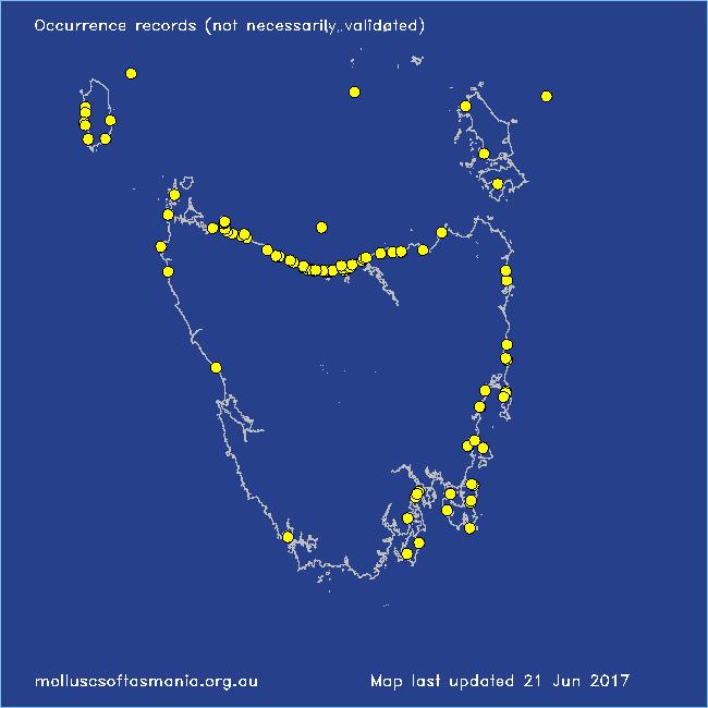
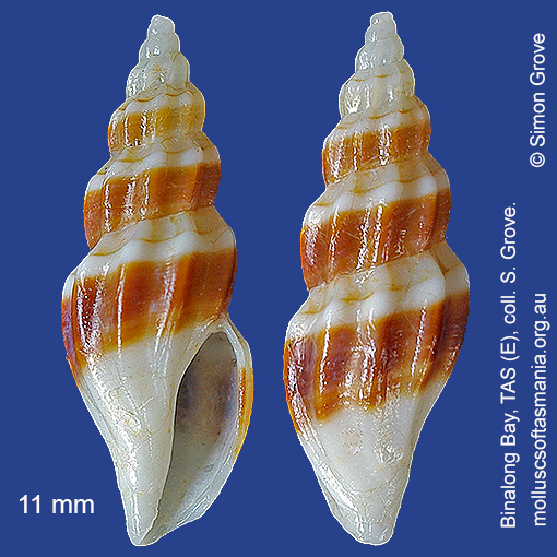
Typical shell-length 17 mm. Variable in shape (from squat to elongate) and in the extent of brown banding (from entirely white to broadly brown). Lives intertidally and subtidally amongst rocks and seaweed. Native. Endemic to southern and eastern Australia (QLD, NSW, TAS, VIC and SA). In Tasmanian waters, this is a widespread species, and the species of Guraleus most likely to be encountered in the S.
Classification
Class: Gastropoda
Subclass: Caenogastropoda – Sorbeoconcha
Order: Hypsogastropoda – Neogastropoda
Superfamily: Conoidea
Family: Mangeliidae
Genus: Guraleus
Localities for Guraleus pictus
Arthur River: Nelson Bay
Bangor: Lagoon Bay
Bangor: Two Mile Beach
Beechford: foreshore
Bellingham
Bicheno: Diamond Island
Bicheno: Waubs Beach
Black River Beach: northern end
Black River Beach: southern end
Bridport: beach
Bridport: East Sandy Point
Burnie: Blythe Heads & estuary
Burnie: Sulphur Creek
Clayton: foreshore
Coles Bay: foreshore
Coles Bay: Honeymoon Bay
Coles Bay: Richardsons Beach
Cooee Beach
Croppies Point
Devonport: Coles Beach
Devonport: Don Heads
Devonport: Mersey River
Devonport: Paradise Cove (unlocalised)
Eaglehawk Neck: eastern side
East Devonport: beach & breakwater
East Devonport: Moorland Beach
East Devonport: Pardoe Beach
East Devonport: Pardoe Point
East Ulverstone
East Ulverstone: Buttons Beach
East Wynyard: beach
Flinders Island: Fotheringate Beach: southern end
Flinders Island: Killiecrankie: foreshore
Flinders Island (unlocalised)
Freycinet Peninsula (unlocalised)
Goat Island: foreshore of island and nearby mainland
Greens Beach: main beach
Hawley Beach
Hawley Beach: foreshore towards Point Sorell
Hunter Island (unlocalised)
King Island: Fitzmaurice Bay
King Island: Grassy Harbour
King Island: Halfmoon Bay
King Island: Naracoopa: foreshore
King Island: Pass River Bay
King Island: Porky Beach
King Island (unlocalised)
Kingston Beach
Leith: foreshore
Lime Bay
Low Head (unlocalised)
Lulworth: Tam O”Shanter Bay
Maria Island: Darlington Bay
Marrawah: West Point
Mayfield Beach to Mayfield Point
Mayfield Point to Little Christmas Island
Narawntapu: Bakers Beach
Narawntapu: Copper Cove
Narawntapu: Griffiths Point
North coast of Tasmania (unlocalised)
Nubeena: Roaring Beach
Okehampton Bay (unlocalised)
Orford: East Shelly Beach
Orford: West Shelly Beach
Penguin: Lonah & Lodders Point
Pipers Head
Pirates Bay (unlocalised)
Port Davey: Whalers Cove
Port Latta: Cowrie Point
Rocky Cape: Castle Rock Bay
Rocky Cape: Forwards Beach
Rocky Cape: Mary Anne Cove area
Seymour Beach: northern end
Somerset: foreshore
South Bruny Island: Adventure Bay – Coal Point
South Bruny Island: Adventure Bay: Grass Point
South Bruny Island: Cloudy Beaches: eastern beach
Stanley: Anthony Beach
Stanley: Circular Head
Stanley: Godfreys Beach
Stanley: Tatlows Beach
Swansea: Jubilee Beach
Tamar River: heads
Taroona: Alum Cliffs
Taroona Beach
Taroona: Dixons Beach
Tasmania (unlocalised)
The Gardens: Mateys Gulch to Gardens Lagoon
The Gardens: Swimcart Beach
Trial Harbour
Turners Beach
Ulverstone (unlocalised)
West Ulverstone: foreshore
Woodbridge: foreshore & Birchs Point
Woolnorth: Valley Bay