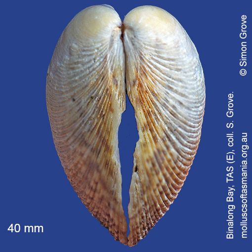
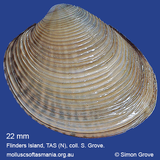
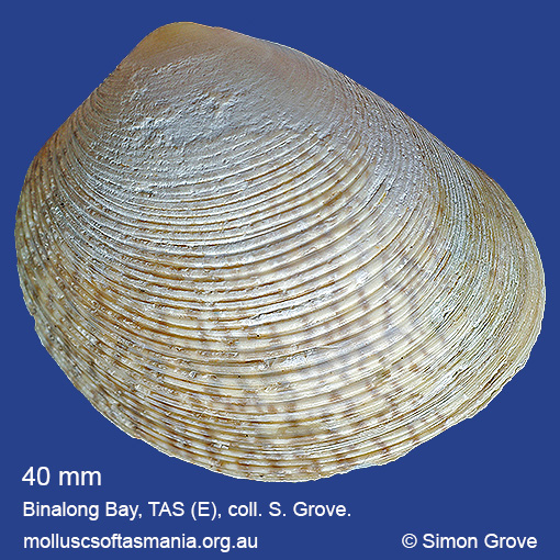
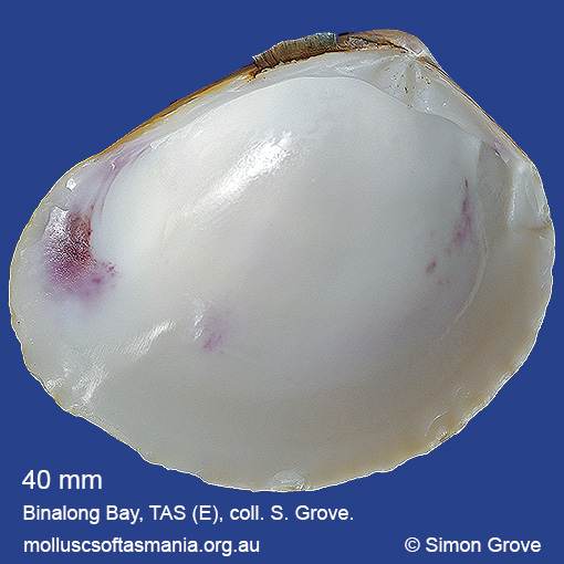
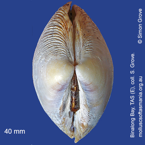
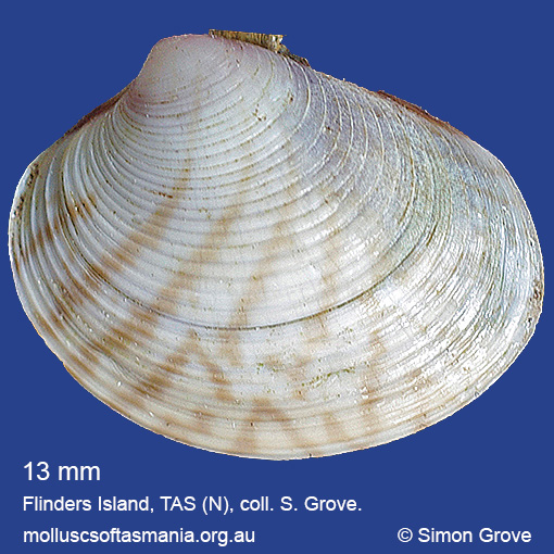
Veneridae – Tapetinae: Katelysia scalarina (Lamarck, 1818) (‘stepped venus’)
Synonym(s): scalarina Lamarck, 1818 aphrodina Lamarck, 1818 conularis Lamarck, 1818 strigosa Lamarck, 1818 enigma Iredale, 1936.
Typical shell-length 40 mm. Shell outline less elongate than K. rhytiphora, and shell lacks radial striations between the concentric ridges, which are relatively strong. Lives intertidally in mud, on sheltered shores. Native. Endemic to southeastern and southwestern Australia (NSW, TAS, VIC, SA and WA). In Tasmanian waters, this is a widespread and locally abundant species.
Classification
Class: Bivalvia
Subclass: Heterodonta
Order: Veneroida
Superfamily: Veneroidea
Family: Veneridae
Subfamily: Tapetinae
Genus: Katelysia
A-L Localities for Katelysia scalarina
Ansons Bay
Bangor: Lagoon Bay
Beaumaris Beach
Bellingham
Binalong Bay: Dora Point
Blackman Bay: Little Chinaman Bay
Blackman Bay: Porpoise Hole
Blackman Bay (unlocalised)
Black River Beach
Black River Beach: northern end
Black River Beach: southern end
Boat Harbour
Boltons Beach
Bridport: Adams Beach
Bridport: beach
Bridport: Lades Beach
Bruny Island: Neck Beach
Bruny Island (unlocalised)
Burnie: Blythe Heads & estuary
Burnie (unlocalised)
Cape Barren Island: Battery Bay
Cape Barren Island: Kenneth Point
Cape Barren Island: Nautilus Cove
Cape Barren Island: Neds Point
Cape Barren Island: Rooks River mouth
Cape Barren Island (unlocalised)
Cape Portland: Boobyalla Beach
Cape Portland: Home Beach
Cape Portland: Petal Point
Cape Portland: Roses Bay
Cape Portland (unlocalised)
Charlotte Cove
Clarke Island: Black Point
Clarke Island: Dip Point to Black Rocks
Clarke Island: Kangaroo Bay to Seal Point
Clarke Island: Maclaines Bay
Clarke Island: Shevo Bay (north end)
Clayton: foreshore
Cockle Creek Bay
Coles Bay: foreshore
Coles Bay: Honeymoon Bay
Coles Bay: Muirs Beach
Coles Bay: Parsons Cove
Coles Bay: Richardsons Beach
Coles Bay (unlocalised)
Coningham Beach
Connellys Bay
Cremorne: foreshore
Cremorne: Pipe Clay Lagoon
Deephole Bay
Devonport: Bluff Beach
Devonport: Coles Beach
Devonport: Don Heads
Devonport: Paradise Cove (unlocalised)
Dover: beach
Dover: Roaring Bay Beach
Dover (unlocalised)
Droughty Point
Dunalley Bay
Dunalley: beach
Dunalley (unlocalised)
Eaglehawk Neck: eastern side
Eaglehawk Neck: western side
Earlham: foreshore
Earlham Lagoon
East Devonport: beach & breakwater
East Devonport: Pardoe Beach
East Ulverstone
East Wynyard: beach
Electrona: Peggys Beach
Flinders Island: Arthur Bay: Long Point
Flinders Island: Cameron Inlet
Flinders Island: Emita: foreshore
Flinders Island: Foochow Inlet
Flinders Island: Fotheringate Bay
Flinders Island: Fotheringate Beach: southern end
Flinders Island: Killiecrankie: foreshore
Flinders Island: Lady Barron: Fisher Island
Flinders Island: Lady Barron: Watering Beach
Flinders Island: Lady Barron: Yellow Beaches
Flinders Island: Lillies Bay
Flinders Island: Northeast River: mouth
Flinders Island: Patriarch Beach
Flinders Island: Patriarch Inlet
Flinders Island: Pot Boil Point
Flinders Island: Sawyers Bay
Flinders Island: Sellars Lagoon
Flinders Island: Spences Reef
Flinders Island: Tanners Bay
Flinders Island: The Dock
Flinders Island: Trousers Point
Flinders Island: Trousers Point: beach
Flinders Island: White Beach to Dick Davey Shoal
Flinders Island: Whitemark Beach
Freycinet Peninsula: Bryans Beach
Freycinet Peninsula: Cooks Beach
Freycinet Peninsula: Hazards Beach
Freycinet Peninsula: Wineglass Bay
Friendly Beaches
Garden Island Sands
Georges Bay: Akaroa: foreshore
Georges Bay: Blanche Point
Georges Bay: Moulting Bay (unlocalised)
Georges Bay: St Helens: foreshore
Georges Bay: Stieglitz: foreshore
Georges Bay (unlocalised)
Glenorchy: Cornelian Bay
Goat Island: foreshore of island and nearby mainland
Granville Harbour
Great Musselroe Bay
Great Musselroe Bay: bar
Greens Beach: main beach
Hawley Beach: foreshore towards Point Sorell
Hellyer Beach
Herlihys Bay: coast to E
Hobart: Sandy Bay (unlocalised)
Howden: foreshore
Ida Bay (unlocalised)
Kettering foreshore
Kettering: Oyster Cove
Kettering: Trial Bay
Kettering (unlocalised)
King Island: Ettrick Beach
King Island: Grassy Harbour
King Island: Lavinia Beach: beach nr Lake Martha Lavinia
King Island: Naracoopa: foreshore
King Island: Sea Elephant Bay: Cowper Point
King Island: Sea Elephant Beach
King Island: Yellow Rock Beach
Kingston Beach
Koonya: Newmans Beach
Koonya: Shelly Beach
Lat -40.5S Long 148.18E Kangaroo Bay, Clarke Island, Furneaux Group, Banks Strait
Lauderdale: Ralphs Bay
Lauderdale: Roches Beach
Lauderdale: Seven Mile Beach
Leith: foreshore
Leith: Lillico Beach
Leven River: mouth
Lime Bay
Lime Bay: Black Rock: beach
Lime Bay: Green Head
Little Coningham Beach
Little Musselroe Bay: Lyme Regis Lagoon
Little Musselroe Bay: northern end
Little Musselroe Bay: Tree Point area
Little Peggs Beach
Little Swanport: Saltworks Beach
Little Swanport (unlocalised)
Louisa Bay
Low Head: East Beach
Low Head (unlocalised)
Lymington: Copper Alley Bay
M-Z Localities for Katelysia scalarina
Macquarie Harbour: Kelly Basin
Margate: Dru Point & Nierinna Creek mouth
Maria Island: Chinamans Bay
Maria Island: Chinamans Creek
Maria Island: Darlington Bay
Maria Island: Encampment Cove
Maria Island: Hopground Beach
Maria Island: Oyster Bay
Maria Island: Point Lesueur
Maria Island: Shoal Bay: McRaes Isthmus
Marion Bay: Bream Creek foreshore
Marion Bay: northern beaches
Marion Bay (unlocalised)
Mayfield Beach to Mayfield Point
Mayfield Point to Little Christmas Island
Middleton: foreshore
Midway Point (unlocalised)
Monk Bay
Mortimer Bay: Gorringes Beach
Moulting Lagoon: Pelican Bay
Murdunna: Duck Creek Beach
Murdunna: Sommers Beach
Musselroe Point
Narawntapu: Badger Beach
Narawntapu: Bakers Beach
Narawntapu: Bakers Point & Springlawn Beach
Narawntapu: Griffiths Point
Narawntapu: Little Badger Head
Narawntapu: Springlawn: North East Arm
North Bruny Island: Barnes Bay
North Bruny Island: Ford Bay
North Bruny Island: Great Bay: Smoothys Point
North Bruny Island: Killora Bay
North Bruny Island: Little Fancy Bay
North Bruny Island: Nebraska Beach
North Bruny Island: Quarantine Bay
North coast of Tasmania (unlocalised)
Nubeena: Parsons Bay
Nubeena: White Beach
Opossum Bay: The Spit & Shelly Beach
Orford: East Shelly Beach
Orford: Millingtons Beach
Orford: Prosser River: mouth
Orford: Raspins Beach
Orford: Shelly Beach (unlocalised)
Orford (unlocalised)
Peggs Beach: eastern end
Peggs Beach (unlocalised)
Peggs Beach: western end
Penguin Point
Petcheys Bay
Pipers Head
Pirates Bay (unlocalised)
Pittwater Bluff: foreshore to W
Pitt Water (unlocalised)
Port Arthur: Little Possum Beach
Port Arthur: Point Puer & beach
Port Arthur: Safety Cove
Port Arthur (unlocalised)
Port Cygnet: Cray Point
Port Cygnet: Sandrock Bay
Port Davey: Bond Bay
Port Davey: Hannant Inlet
Port Davey: Whalers Cove
Port Esperance: Hawkers Green
Port Esperance: Stringers Cove
Port Latta: Cowrie Point
Port Latta: Crayfish Creek
Port Sorell: beach
Port Sorell (unlocalised)
Premaydena: Impression Bay
Ralphs Bay: Maria Point
Ralphs Bay (unlocalised)
Randalls Bay
Ransons Beach
Rheban Beach
Rocky Cape: foreshore N of Picnic Beach
Rocky Cape: Forwards Beach
Rocky Cape: Picnic Beach & rocks to S
Rocky Cape (unlocalised)
Rokeby Beach
Saltwater River: Coal Mines beach
Sandford: Clear Lagoon
Sandy Bay: Nutgrove Beach
Schouten Island: Crocketts Bay
Shearwater: Freers Beach
Sloping Main Beach
Sloping Main: Black Jack Point
Smithton: Duck River mouth
Smithton: Perkins Island
Snug Beach
Somerset: foreshore
Sorell: causeway
Sorell: Oaks Point
South Arm: beach
South Arm: Fort Beach
South Arm Neck: northern side
South Arm: Pigeon Holes
South Bruny Island: Adventure Bay: Cemetery Bluff
South Bruny Island: Adventure Bay: southern end
South Bruny Island: Adventure Bay (unlocalised)
South Bruny Island: Alonnah Beach
South Bruny Island: Bay of Islands
South Bruny Island: Cloudy Bay Lagoon
South Bruny Island: Cloudy Beaches: eastern beach
South Bruny Island: Cloudy Beaches: western beach
South Bruny Island: Great Taylors Bay
South Bruny Island: Little Taylors Bay
South Bruny Island: Lunawanna: Daniels Bay
South Bruny Island: Mickeys Bay
South Bruny Island: Simpsons Bay
South Bruny Island: Simpsons Bay: southern end
South Bruny Island (unlocalised)
South coast of Tasmania (unlocalised)
Southport
Southport Bluff: beach
Southport Lagoon: northern end
Southport Lagoon: southern end
Stanley: Anthony Beach
Stanley: Circular Head
Stanley: East Inlet
Stanley: Godfreys Beach
Stanley: Green Hills: West Inlet entrance
Stanley: Halfmoon Bay
Stanley: Tatlows Beach
Stanley (unlocalised)
Stanley: West Inlet
St Helens Point
Swansea: Lisdillon Beach
Swansea (unlocalised)
Tamar River: Clarence Point: foreshore
Tamar River: George Town: foreshore
Tamar River: Kelso: foreshore
Tamar River: Swan Bay
Tamar River: West Arm
Taroona Beach
Tasmania (unlocalised)
The Gardens: Coffeys Gulch
The Gardens: Swimcart Beach
Tomahawk Beach
Turners Beach
Ulverstone (unlocalised)
Walker Island
Welcome River: mouth
West Ulverstone: foreshore
Weymouth: beach
Woodbridge: Birchs Bay & Yellow Point
Woodbridge: Fleurtys Bay & Point
Woodbridge: Flowerpot
Woodbridge: foreshore & Birchs Point
Wykeholm Point & Bay
Wynyard: Inglis River mouth
Wynyard (unlocalised)