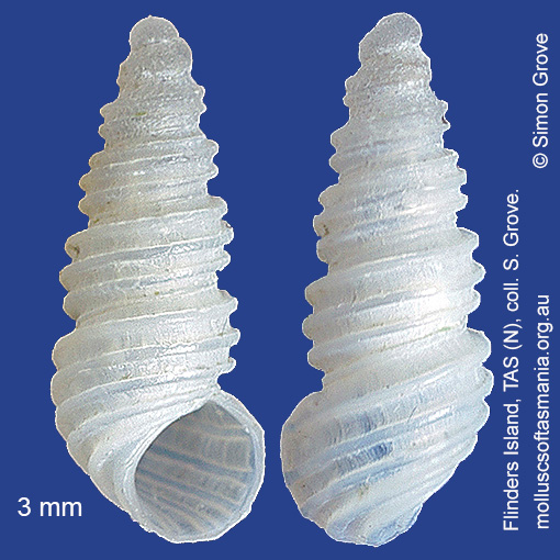
Lironobidae: Lironoba australis (Tenison-Woods, 1877) (‘southern rice-shell’)
Synonym(s): australis Tenison-Woods, 1876 tenisoni Tate, 1899.
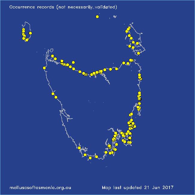
Typical shell-length 3.0 mm. Lives subtidally amongst rocks and seaweed. Native. Endemic to southeastern Australia (NSW, TAS, VIC and SA). In Tasmanian waters, this is a widespread and common species.
Classification
Class: Gastropoda
Subclass: Caenogastropoda – Sorbeoconcha
Order: Hypsogastropoda – Littorinimorpha
Superfamily: Rissooidea
Family: Lironobidae
Genus: Lironoba
A-L Localities for Lironoba australis
Badger Island
Bangor: Lagoon Bay
Bangor: Two Mile Beach
Beechford: foreshore
Bellerive Beach
Bicheno: Cod Rock
Bicheno: Redbill Beach
Bicheno: Waubs Beach
Binalong Bay: beach
Binalong Bay: Jeanneret Beach
Blackmans Bay
Black River Beach: northern end
Black River Beach: southern end
Boat Harbour: beach
Bridport: beach
Bridport (unlocalised)
Burnie: Blythe Heads & estuary
Cape Barren Island (unlocalised)
Cape Portland: Home Beach
Cape Portland: Roses Bay
Cape Portland (unlocalised)
Carlton: Park Beach
Chain of Lagoons: Piccaninny Point
Clarke Island: Black Point
Clayton: foreshore
Coles Bay: Richardsons Beach
Coles Bay (unlocalised)
Conical Harbour
Coningham: foreshore
Curtis Island
Denison Beach: Porch Rocks
De Witt Island
Dunalley (unlocalised)
Eaglehawk Neck: eastern side
East Devonport: Moorland Beach
East Devonport: Pardoe Point
East Wynyard: beach
Flinders Island: Arthur Bay: Long Point
Flinders Island: Badger Corner
Flinders Island: Fotheringate Beach: southern end
Flinders Island: Killiecrankie: foreshore
Flinders Island: Leeka: foreshore towards Twelve Hour Point
Flinders Island: Lillies Bay
Flinders Island: The Dock
Fortescue Bay
Freycinet Peninsula (unlocalised)
Friendly Beaches
Garden Island Sands
Georges Bay: Blanche Point
Granville Harbour: coast to N
Greens Beach: main beach
Hawley Beach
Hawley Beach: foreshore towards Point Sorell
Huon Island
King Island: Cataraqui Point
King Island: Colliers Beach
King Island: Currie Harbour
King Island: Ettrick Beach
King Island: Fitzmaurice Bay
King Island: Halfmoon Bay
King Island: Little Porky Beach
King Island: Naracoopa: foreshore
King Island: Pass River Bay
King Island: Seal Point
King Island (unlocalised)
Lime Bay
Lime Bay: Green Head
Little Swanport: mouth
Little Swanport (unlocalised)
Low Head: East Beach
M-Z Localities for Lironoba australis
Maria Island: Bloodstone Point
Maria Island: Darlington Bay
Maria Island: Four Mile Beach
Maria Island: Gulls Nest Point
Maria Island: Howells Point & Painted Cliffs
Maria Island: Oyster Bay
Maria Island: Trigonia Corner
Marion Bay: Bream Creek foreshore
Marrawah: West Point
Narawntapu: Badger Head
Narawntapu: Copper Cove
New Harbour
North Bruny Island: Variety Bay
North West coast of Tasmania (unlocalised)
Nubeena: Roaring Beach
Nubeena: White Beach
Okehampton Bay (unlocalised)
Orford: East Shelly Beach
Orford: Spring Beach
Orford: West Shelly Beach
Penguin: Lonah & Lodders Point
Pipers Head
Pirates Bay: Fossil Island
Pirates Bay: middle rocks
Pirates Bay (unlocalised)
Port Arthur: Denmans Cove
Port Cygnet: Cray Point
Port Davey: Whalers Cove
Port Latta: Cowrie Point
Primrose Sands
Randalls Bay
Rheban Beach
Robbins Island: Marys Island area
Rocky Boat Inlet
Rocky Cape: Forwards Beach
Seymour Beach: northern end
South Bruny Island: Adventure Bay: Cemetery Bluff
South Bruny Island: Adventure Bay: East Cove
South Bruny Island: Adventure Bay: Grass Point
South Bruny Island: Cloudy Beaches: eastern beach
South Bruny Island: Great Taylors Bay
Southport: Roaring Beach
Stanley: Godfreys Beach
Stanley: Tatlows Beach
Swanwick: foreshore
Tamar River: Kelso: foreshore
Taroona: Alum Cliffs
Taroona Beach
Taroona: Dixons Beach
Tasmania (unlocalised)
The Gardens: Coffeys Gulch
The Gardens: Swimcart Beach
Tinderbox Beach
Triabunna: Plain Place Beach
Ulverstone (unlocalised)
Walker Island
Waterhouse Point
West Ulverstone: foreshore