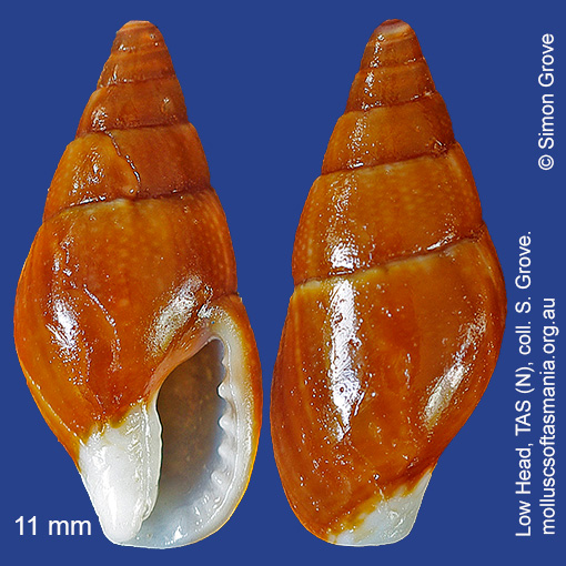
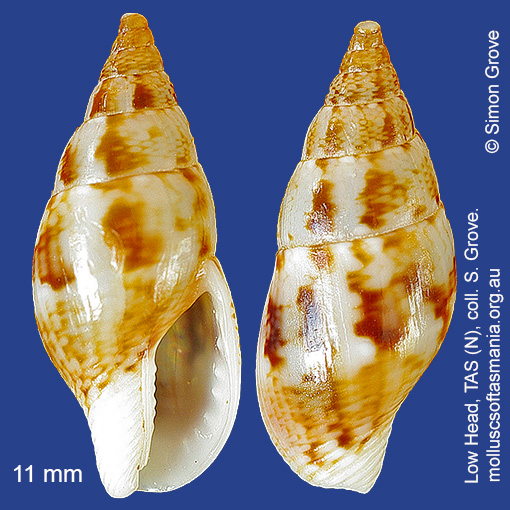
Columbellidae – Atiliinae: Mitrella (Dentimitrella) tenuis (Gaskoin, 1851) (‘white-based dove-shell’)
Synonym(s): tenuis Gaskoin, 1851 pulla Gaskoin, 1852 fulgida Reeve, 1859 saccharrata Reeve, 1859 nux Reeve, 1859.
Typical shell-length 16 mm. Colouration variable, but tendency for base of columella to be white is characteristic. Lives subtidally amongst rocks and seaweed. Native. Endemic to southeastern and southwestern Australia (NSW, TAS, VIC, SA and WA). In Tasmanian waters, this is a widespread but uncommon species; most frequent in the N.
Classification
Class: Gastropoda
Subclass: Caenogastropoda – Sorbeoconcha
Order: Hypsogastropoda – Neogastropoda
Superfamily: Buccinoidea
Family: Columbellidae
Subfamily: Atiliinae
Genus: Mitrella
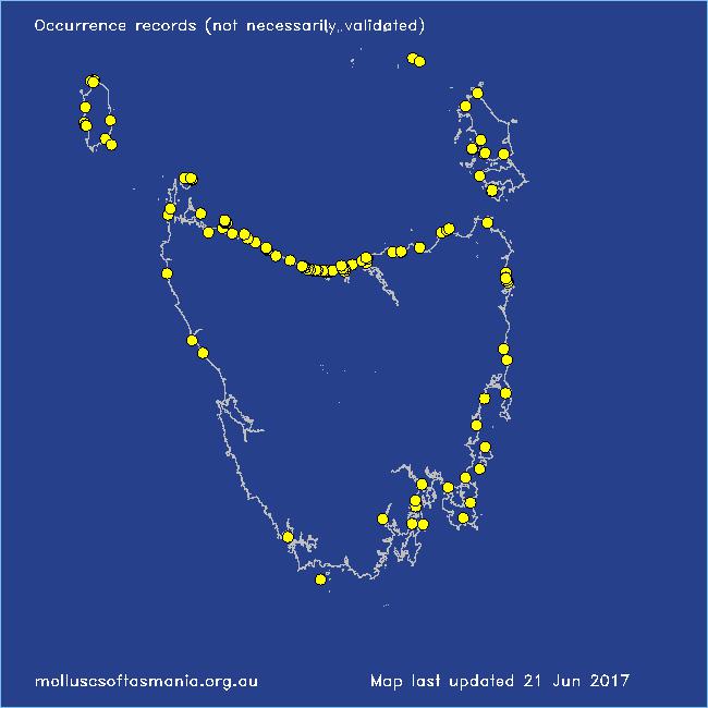
Localities for Mitrella tenuis
Arthur River: Sarah Anne Rocks
Bellingham
Bicheno
Binalong Bay
Blackmans Bay
Boat Harbour: beach
Boltons Beach
Bridport: Lades Beach
Burnie: Blythe Heads & estuary
Camdale: beach
Cape Barren Island: Bungs Beach
Clarke Island: Dip Point to Black Rocks
Clarke Island: Maclaines Bay
Clayton: foreshore
Coles Bay: Honeymoon Bay
Conical Harbour
Croppies Point
Devonport: Bluff Beach
Devonport: Don Heads
Devonport: Mersey River
Devonport: Paradise Cove (unlocalised)
Douglas River: beach
East Devonport: beach & breakwater
East Devonport: Moorland Beach
East Devonport: Pardoe Beach
East Devonport: Pardoe Point
East Kangaroo Island: North Point
East Kangaroo Island (unlocalised)
East Ulverstone
East Ulverstone: Buttons Beach
East Wynyard: beach
Flinders Island: Fotheringate Bay
Flinders Island: Fotheringate Beach: southern end
Flinders Island: Killiecrankie: foreshore
Flinders Island: Lady Barron: Fisher Island
Flinders Island: Northeast River: mouth
Flinders Island: Parrys Bay: Double Corner
Goat Island: foreshore of island and nearby mainland
Granville Harbour
Greens Beach: main beach
Hawley Beach
Hawley Beach: foreshore towards Point Sorell
Herbies Landing
Howrah Beach
King Island: British Admiral Beach
King Island: Cape Wickham
King Island: Cape Wickham: foreshore to E
King Island: Foreshore S of Currie
King Island: Grassy Harbour
King Island: Halfmoon Bay
King Island: Naracoopa: foreshore
King Island: Pass River Bay
King Island: Seal Bay: Black Point
King Island (unlocalised)
King Island: Victoria Cove
Leith: foreshore
Leith: Lillico Beach
Little Musselroe Bay: Tree Point area
Low Head: East Beach
Low Head (unlocalised)
Lulworth: Tam O”Shanter Bay
Maatsuyker Island
Maria Island: Fossil Cliffs
Marion Bay: Bream Creek foreshore
Narawntapu: Copper Cove
Narawntapu: Griffiths Point
North Bruny Island: Variety Bay
Penguin: Lonah & Lodders Point
Penguin to Ulverstone: foreshore
Pipers Head
Pirates Bay (unlocalised)
Port Davey: Whalers Cove
Port Huon (unlocalised)
Port Latta: Cowrie Point
Port Sorell: beach
Primrose Point
Robbins Island: Marys Island area
Rocky Cape: Anniversary Bay
Rocky Cape: foreshore N of Picnic Beach
Smithton: Duck River mouth
Somerset: foreshore
South East coast of Tasmania (unlocalised)
Stanley: Circular Head
Stanley: Cow Rock beach
Stanley: East Inlet
Stanley: Godfreys Beach
Stanley (unlocalised)
Swansea: Spiky Beach
Tamar River: heads
Tamar River: Kelso: foreshore
Tasmania (unlocalised)
The Gardens: beach
The Gardens: Cosy Corner
The Gardens: Seatons Cove
The Gardens: Swimcart Beach
Three Hummock Island: Mermaid Bay
Three Hummock Island: Ranger Retreat
Three Hummock Island: Three Gullies Bay
Three Hummock Island: Three Gullies Bay area
Tinderbox Beach
Turners Beach
Ulverstone (unlocalised)
Waterhouse Point
West Ulverstone: foreshore
Woolnorth: Valley Bay
Woolnorth: Woolnorth Point
Wynyard: Fossil Bluff