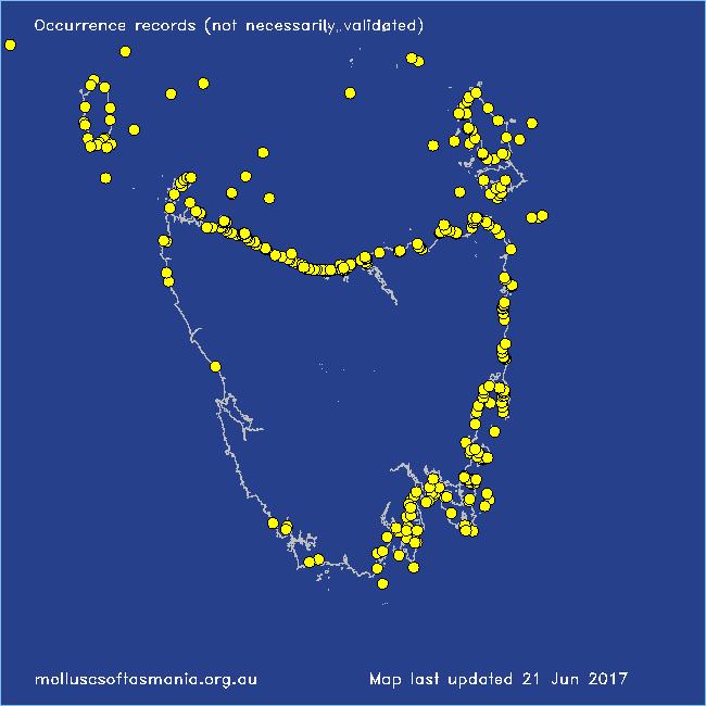
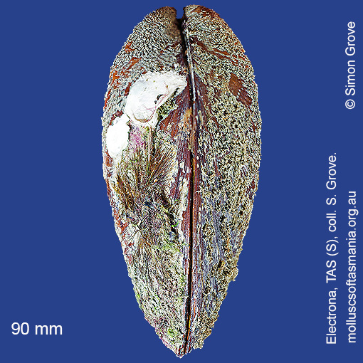
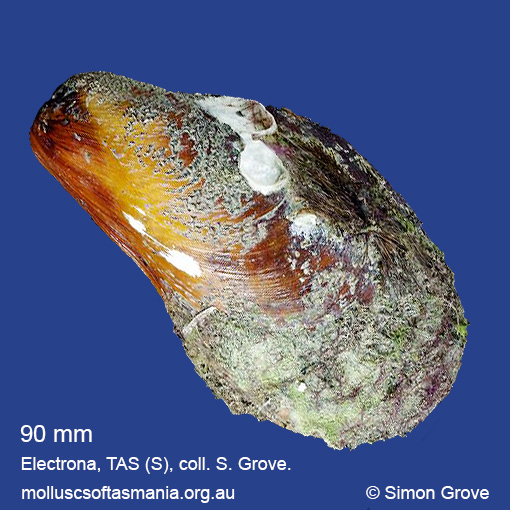
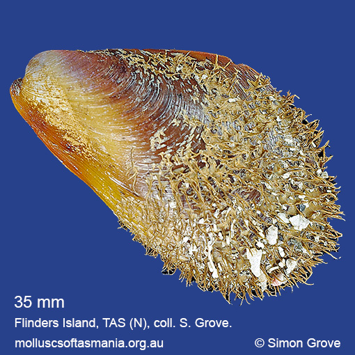
Mytilidae: Modiolus areolatus (Gould, 1850) (‘bearded horse-mussel’)
Synonym(s): areolatus Gould, 1850 cottoni Laseron, 1956.
Typical shell-length 90 mm. Periostracum hairy towards growing margin of shell, and persistent. Lives subtidally and offshore amongst rocks and seaweed, especially in moderately sheltered environments; often embedded in sponges. Native. Endemic to southeastern and southwestern Australia (NSW, TAS, VIC, SA and WA). In Tasmanian waters, this is a widespread and common species.
Classification
Class: Bivalvia
Subclass: Pteriomorphia
Order: Mytiloida
Superfamily: Mytiloidea
Family: Mytilidae
Genus: Modiolus
A-L Localities for Modiolus lineus
Arthur River: Sarah Anne Rocks
Bangor: Lagoon Bay
Bangor: Tasman Bay
Bangor: Two Mile Beach
Bangor: Watsons Bay
Beaumaris Beach
Beaumaris: Shelly Point
Beechford: foreshore
Beerbarrel Beach
Bellingham
Bicheno: Diamond Island
Bicheno: Redbill Beach
Bicheno: Waubs Beach
Blackman Bay: Little Chinaman Bay
Blackman Bay: Long Spit: bay to E
Black River Beach: northern end
Black River Beach: southern end
Boat Harbour
Boat Harbour: beach
Boltons Beach
Bridport: Adams Beach
Bridport: beach
Bridport: East Sandy Point
Bridport: Lades Beach
Bridport (unlocalised)
Bruny Island (unlocalised)
Burnie: Blythe Heads & estuary
Burnie: Sulphur Creek
Burnie: Titan Point
Burnie (unlocalised)
Calverts Beach & Goats Bluff
Cape Barren Island: Kent Bay
Cape Barren Island: Key Island Bay
Cape Portland: Boobyalla Beach
Cape Portland: Home Beach
Cape Portland: Lanoma Point
Cape Portland: Lemons Beach
Cape Portland: Petal Point
Cape Portland: Roses Bay
Cape Portland (unlocalised)
Chain of Lagoons: Four Mile Creek: beach
Clarke Island: Black Point
Clarke Island: Kangaroo Bay to Seal Point
Clarke Island: Moriarty Bay
Clarke Island: Shevo Bay (north end)
Clarke Island: Spike Bay
Clayton: foreshore
Clifton Beach: western end
Coles Bay: Honeymoon Bay
Coles Bay: Parsons Cove
Coles Bay: Richardsons Beach
Coles Bay (unlocalised)
Coningham: foreshore
Cox Bight (unlocalised)
Cremorne: foreshore
Cremorne: Pipe Clay Head to Cape Deslacs
Croppies Beach: northern end
Croppies Point
Davey River: Carvers Point
Denison Beach: Porch Rocks
Denison Beach: rocks at southern end
Denison Beach (unlocalised)
Devonport: Back Beach
Devonport: Bluff Beach
Devonport: Coles Beach
Devonport: Don Heads
Devonport: Mersey River
Devonport (unlocalised)
Dover: beach
Eaglehawk Neck: eastern side
East Devonport: beach & breakwater
East Devonport: Moorland Beach
East Devonport: Moorland Point
East Devonport: Pardoe Beach
East Devonport: Pardoe Beach: The Water Rat
East Devonport: Pardoe Point
East Ulverstone
East Ulverstone: Buttons Beach
East Wynyard: beach
E coast of Tasmania (unlocalised)
Eddystone Point (unlocalised)
Electrona: Peggys Beach
Falmouth: foreshore
Flinders Island: Arthur Bay: Long Point
Flinders Island: Beach S of Big River Road
Flinders Island: Cameron Inlet
Flinders Island: Foochow Beach
Flinders Island: Fotheringate Beach: southern end
Flinders Island: Killiecrankie Bay (unlocalised)
Flinders Island: Killiecrankie: foreshore
Flinders Island: Lady Barron: Fisher Island
Flinders Island: Leeka: foreshore towards Twelve Hour Point
Flinders Island: Leeka: West End Beach
Flinders Island: Lillies Bay
Flinders Island: Northeast River: mouth
Flinders Island: Palana Beach
Flinders Island: Patriarch Beach
Flinders Island: Port Davies & Cave Beach
Flinders Island: Sawyers Bay
Flinders Island: Tanners Bay
Flinders Island: Tanners Bay: Pine Scrub
Flinders Island: The Dock
Flinders Island: Tongue Point
Flinders Island: Trousers Point
Flinders Island: Trousers Point: beach
Flinders Island: White Beach to Dick Davey Shoal
Frederick Henry Bay (unlocalised)
Freycinet Peninsula: Bryans Beach
Freycinet Peninsula: Cooks Beach
Freycinet Peninsula: Hazards Beach
Freycinet Peninsula (unlocalised)
Freycinet Peninsula: Wineglass Bay
Goat Island: foreshore of island and nearby mainland
Gordon: Three Hut Point
Great Musselroe Bay
Greens Beach: main beach
Hawley Beach: foreshore towards Point Sorell
Hellyer Beach
Herbies Landing
Howden: foreshore
Hunter Island: Cave Bay
Hunter Island (unlocalised)
Ida Bay (unlocalised)
King Island: Cape Wickham: foreshore to E
King Island: Colliers Beach
King Island: Currie Harbour
King Island: Fitzmaurice Bay
King Island: Grassy Harbour
King Island: Grassy Harbour: Sandblow Bay
King Island: Halfmoon Bay
King Island: Lavinia Beach: beach nr Lake Martha Lavinia
King Island: Naracoopa: foreshore
King Island: Pass River Bay
King Island: S coast (unlocalised)
King Island: Sea Elephant Bay: Cowper Point
King Island: Seal Bay: Black Point
King Island: Seal Point
King Island (unlocalised)
King Island: W coast
King Island: Yellow Rock Beach
Kingston Beach
Lat -40.5S Long 148.18E Kangaroo Bay, Clarke Island, Furneaux Group, Banks Strait
Lauderdale: Roches Beach
Lauderdale: Seven Mile Beach
Leith: Lillico Beach
Little Chalky Island
Little Musselroe Bay: Tree Point area
Little Peggs Beach
Little Swanport: Saltworks Beach
Low Head: East Beach
Low Head: Lagoon Beach
Low Head (unlocalised)
M-Z Localities for Modiolus lineus
Maria Island: Chinamans Bay
Maria Island: Encampment Cove
Maria Island: Gulls Nest Point
Maria Island: Point Lesueur
Maria Island: Return Point
Maria Island: Riedlé Bay: McRaes Isthmus
Maria Island: Shoal Bay: McRaes Isthmus
Maria Island: Trigonia Corner
Marion Bay: Bream Creek foreshore
Marrawah: Green Point
Marrawah: Green Point Beach
Marrawah (unlocalised)
Mayfield Beach to Mayfield Point
Mayfield Point to Little Christmas Island
Mercury Passage: ACMA Asterias survey Stn 06
Middleton: foreshore
Musselroe Point
Narawntapu: Bakers Beach
Narawntapu: Bakers Point & Springlawn Beach
Narawntapu: Copper Cove
Narawntapu: Griffiths Point
Narawntapu: Little Badger Head
Nine Mile Beach & Dolphin Sands
North Bruny Island: Roberts Point
Northdown Beach
Nubeena: White Beach
Orford: Emerald Beach
Orford: Raspins Beach
Peggs Beach (unlocalised)
Penguin: Johnsons Beach
Penguin: Lonah & Lodders Point
Penguin Point
Pipers Head
Pirates Bay (unlocalised)
Planters Beach to Fishers Point
Port Davey: Bond Bay
Port Latta: Cowrie Point
Port Sorell: beach
Randalls Bay
Ransons Beach
Rheban Beach
Robbins Island: East Beach
Robbins Island: Marys Island area
Robbins Island: Ransonnet Bay
Rocky Cape: Anniversary Bay
Rocky Cape: Burgess Cove
Rocky Cape: Castle Rock Bay
Rocky Cape: Cave Bay
Rocky Cape: foreshore N of Picnic Beach
Rocky Cape: Forwards Beach
Rocky Cape: Mary Anne Cove area
Rocky Cape: Picnic Beach & rocks to S
Rocky Cape (unlocalised)
Scamander: Steels Beach
Scamander (unlocalised)
Scamander: Wrinklers Beach
Schouten Island: Crocketts Bay
Seymour Beach: northern end
Shearwater: Freers Beach
Sisters Beach
Sloping Main Beach
Sloping Main: Black Jack Point
Smithton: Duck Bay: Picnic Point
Snug Beach
Somerset: foreshore
South Arm: Hope Beach: southern end
South Bruny Island: Adventure Bay: Cemetery Bluff
South Bruny Island: Adventure Bay: East Cove
South Bruny Island: Adventure Bay (unlocalised)
South Bruny Island: Old Jetty Beach
South Croppies Point
Southport
Stanley: Anthony Beach
Stanley: Circular Head
Stanley: East Inlet
Stanley: Godfreys Beach
Stanley: Tatlows Beach
Stanley (unlocalised)
Stanley: West Inlet
St Helens Point
Stumpys Bay (unlocalised)
Swansea: Coswell Beach
Swansea: Jubilee Beach
Swansea: Spiky Beach
Swansea (unlocalised)
Swanwick: foreshore
Tamar River: channel entrance
Tamar River: Kelso: foreshore
Taroona Beach
Tasmania (unlocalised)
Temma
The Gardens: Cosy Corner
The Gardens: Swimcart Beach
Three Hummock Island: Coulomb Bay
Three Hummock Island: Mermaid Bay
Three Hummock Island: Rape Bay
Three Hummock Island: Sandy Spit
Three Hummock Island: Spiers Bay: Spiers Nook
Three Hummock Island: Three Gullies Bay: northern end
Tomahawk Beach
Tomahawk Island
Trial Harbour
Trial Harbour area
Turners Beach
Verona Sands
Walker Island
Waterhouse Island
West Ulverstone: foreshore
Weymouth: beach
Woodbridge: foreshore & Birchs Point
Woolnorth: Woolnorth Point
Wynyard: Fossil Bluff
Wynyard: Inglis River mouth
Wynyard (unlocalised)