Neritidae – Neritinae: Nerita (Lisanerita) atramentosa Reeve, 1855 (‘western black nerite’)
Synonym(s): atramentosa Reeve, 1855 atrata Gmelin, 1791 saturata Hutton, 1884.
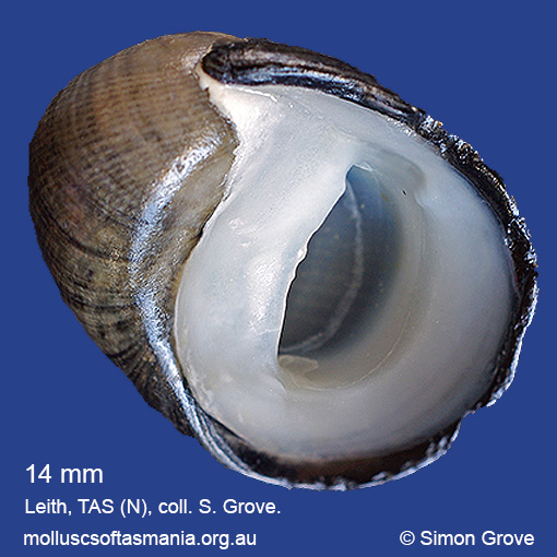
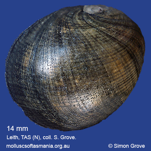
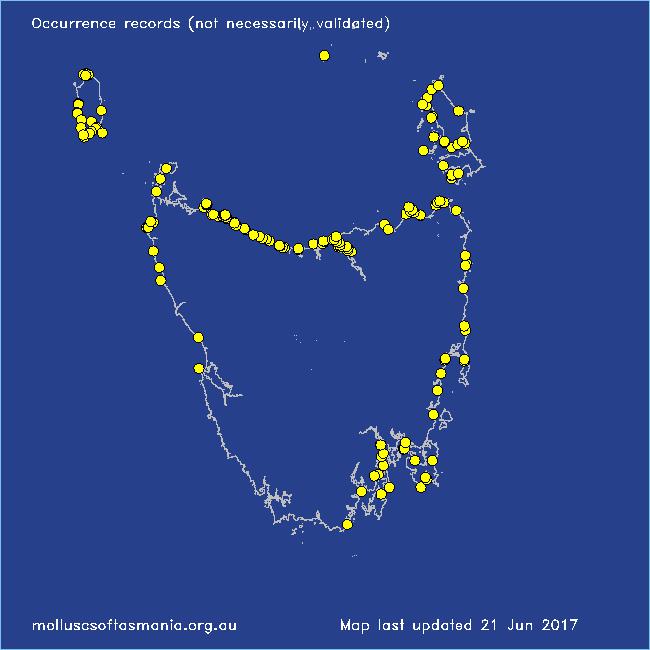
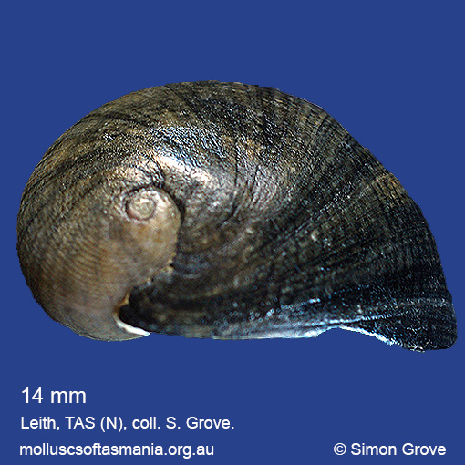
Typical shell-length 20 mm. Shell generally indistinguishable from that of N. melanotragus, but often smaller, and the entirely black operculum of the living animal is characteristic. Lives intertidally on rocks. Native. Endemic to southeastern and southwestern Australia (NSW, TAS, VIC, SA and WA). In Tasmanian waters, this is the dominant, and usually only, Nerita species on the N, S and W coasts; in the E and far NE and around Flinders Island it occurs alongside N. melanotragus, but is usually outnumbered by that species.
Classification
Class: Gastropoda
Subclass: Neritimorpha
Order: Neritimorpha – Cycloneritimorpha
Superfamily: Neritoidea
Family: Neritidae
Subfamily: Neritinae
Genus: Nerita
A-L Localities for Nerita atramentosa
Arthur River: Australia Point
Arthur River: Couta Rocks
Arthur River: Nelson Bay
Arthur River: Sarah Anne Rocks
Arthur River: Sundown Point
Bangor: Lagoon Bay
Beechford: foreshore
Bellingham
Bicheno
Bicheno: Waubs Beach
Binalong Bay: Jeanneret Beach
Black River Beach: northern end
Boat Harbour
Boat Harbour: beach
Boat Harbour: Western Bay
Boltons Beach
Bridport: Adams Beach
Bridport: beach
Bridport: East Sandy Point
Bridport: Lades Beach
Burnie: Blythe Heads & estuary
Burnie: Sulphur Creek
Burnie (unlocalised)
Cape Barren Island: Bungs Beach
Cape Portland: Home Beach
Cape Portland: Lanoma Point
Cape Portland: Petal Point
Cape Portland: Roses Bay
Cape Portland (unlocalised)
Clarke Island: Allens Point: beach to west
Clarke Island: Dip Point to Black Rocks
Clarke Island: Maclaines Bay
Clarke Island: Spike Bay
Clayton: foreshore
Coles Bay: foreshore
Coles Bay: Honeymoon Bay
Conical Harbour
Cooee Beach
Croppies Beach: northern end
Curtis Island
Devonport: Bluff Beach
Devonport: Coles Beach
Devonport: Don Heads
Devonport: Mersey River
Devonport: Paradise Cove (unlocalised)
Devonport (unlocalised)
Dodges Ferry: Red Ochre Beach
Dover: Roaring Bay Beach
Earlham: foreshore
East Devonport: beach & breakwater
East Devonport: Moorland Beach
East Devonport: Moorland Point
East Devonport: Pardoe Beach
East Devonport: Pardoe Beach: The Water Rat
East Devonport: Pardoe Point
East Kangaroo Island (unlocalised)
East Ulverstone
East Ulverstone: Buttons Beach
East Wynyard: beach
Edgcumbe Beach
Falmouth: foreshore
Flinders Island: Badger Corner
Flinders Island: Emita: foreshore
Flinders Island: Killiecrankie: foreshore
Flinders Island: Lady Barron: Fisher Island
Flinders Island: Leeka: foreshore towards Twelve Hour Point
Flinders Island: Northeast River: mouth
Flinders Island: Palana Beach
Flinders Island: Patriarch Beach
Flinders Island: Port Davies & Cave Beach
Flinders Island: Sawyers Bay
Flinders Island: Tanners Bay: Pine Scrub
Flinders Island: Trousers Point
Flinders Island: Trousers Point: beach
Franklin Sound area
Frederick Henry Bay (unlocalised)
Georges Bay: Humbug Point
Goat Island: foreshore of island and nearby mainland
Goose Island
Granville Harbour
Granville Harbour: coast to N
Great Dog Island: beaches in NE
Great Musselroe Bay
Greenes Creek: beach
Greenes Point
Greens Beach: Friend Point
Greens Beach: main beach
Greens Beach: Nudists Beach
Hawley Beach
Hawley Beach: foreshore towards Point Sorell
Hellyer Beach
Herbies Landing
Hunter Island (unlocalised)
King Island: British Admiral Beach
King Island: Cape Wickham
King Island: Cape Wickham: foreshore to E
King Island: City of Melbourne Bay
King Island: Colliers Beach
King Island: Currie Harbour
King Island: Disappointment Bay
King Island: Ettrick Beach
King Island: Fitzmaurice Bay
King Island: Grassy Harbour
King Island: Grassy Harbour: Sandblow Bay
King Island: Halfmoon Bay
King Island: Little Porky Beach
King Island: Naracoopa: foreshore
King Island: Pass River Bay
King Island: Porky Beach
King Island: Red Hut Point
King Island: Seal Bay: Black Point
King Island: Seal Point
King Island: Stokes Point: Gulchway
King Island: Surprise Bay
King Island (unlocalised)
King Island: Victoria Cove
King Island: W coast
Kingston Beach
Lagoon River: mouth
Leith: foreshore
Little Musselroe Bay: northern end
Little Peggs Beach
Louisa Bay
Low Head: East Beach
Low Head: Lagoon Beach
Low Head (unlocalised)
Lulworth: Tam O”Shanter Bay


M-Z Localities for Nerita atramentosa
Marrawah: Green Point
Marrawah: Green Point Beach
Marrawah (unlocalised)
Marrawah: West Point
Mayfield Point to Little Christmas Island
Montagu: beach
Musselroe Point
Narawntapu: Badger Beach
Narawntapu: Badger Head
Narawntapu: Bakers Beach
Narawntapu: Bakers Point & Springlawn Beach
Narawntapu: Copper Cove
Narawntapu: Griffiths Point
Narawntapu: Little Badger Head
North Bruny Island: Cape Queen Elizabeth
North Bruny Island: Dennes Point
North Bruny Island: Roberts Point
Northdown Beach
North West coast of Tasmania (unlocalised)
Orford: Emerald Beach
Peggs Beach (unlocalised)
Penguin: beach
Penguin: Johnsons Beach
Penguin: Lonah & Lodders Point
Penguin Point
Penguin: Watcombe Beach
Pipers Head
Point Sorell and foreshore to SW
Point Sorell: Margaret Rocks
Port Arthur: Dog Bark Beach
Port Arthur: Little Possum Beach
Port Arthur (unlocalised)
Port Latta: Brickmakers Beach
Port Latta: Cowrie Point
Port Sorell: beach
Ransons Beach
Robbins Island: East Beach
Robbins Island: Marys Island area
Rocky Boat Inlet
Rocky Cape: Anniversary Bay
Rocky Cape: Burgess Cove
Rocky Cape: Castle Rock Bay
Rocky Cape: Cathedral Rocks Bay
Rocky Cape: Cave Bay
Rocky Cape: foreshore N of Picnic Beach
Rocky Cape: Forwards Beach
Rocky Cape: Mary Anne Cove area
Rocky Cape: northern coves
Rocky Cape: Picnic Beach & rocks to S
Rocky Cape (unlocalised)
Saltwater River (unlocalised)
Sandy Cape
Shearwater: Freers Beach
Sisters Beach
Smiths Gulch
Smithton: Duck Bay
Somerset: foreshore
South Bruny Island: Neck Beach: Blighs Rocks
Stanley: Circular Head
Stanley: Cow Rock beach
Stanley: East Inlet
Stanley: foreshore
Stanley: Godfreys Beach
Stanley: Green Hills: West Inlet entrance
Stanley: Halfmoon Bay
Stanley (unlocalised)
Strahan: Cape Sorell
Swansea: Jubilee Beach
Swansea (unlocalised)
Tamar River: Bell Bay: Big Bay
Tamar River: Bell Bay: Deceitful Cove
Tamar River: Bell Bay: Middle Island
Tamar River: Bell Bay: power-station jetty
Tamar River: Bell Bay: Sawyers Point
Tamar River: Clarence Point: foreshore
Tamar River: East Arm
Tamar River: George Town: foreshore
Tamar River: George Town: She Oak Point area
Tamar River: heads
Tamar River: Ilfraville: Sandy Beach
Tamar River: Kelso: foreshore
Tamar River: Long Reach
Tamar River: Rosevears: foreshore
Tamar River: Rowella: West Bay
Tamar River: Rowella: Willmores Bluff
Taroona: Hinsby Beach
Tasmania (unlocalised)
Temma
The Gardens: Coffeys Gulch
Three Hummock Island: Mermaid Bay
Three Hummock Island: Ranger Retreat
Three Hummock Island: Rape Bay
Three Hummock Island: Spiers Bay: Spiers Nook
Three Hummock Island: Three Gullies Bay area
Three Hummock Island: Three Gullies Bay: northern end
Three Hummock Island: Three Gullies Bay: southern end
Three Hummock Island: West Telegraph Beach
Tomahawk Beach
Trial Harbour
Trial Harbour area
Turners Beach
Ulverstone (unlocalised)
Walker Island
Waterhouse Island
Waterhouse Point
West Ulverstone: foreshore
West Ulverstone: Picnic Point: beach to W
Weymouth: beach
Woodbridge: foreshore & Birchs Point
Woolnorth: Davisons Bay
Woolnorth: Valley Bay
Woolnorth: Woolnorth Point
Wynyard: Fossil Bluff
Wynyard (unlocalised)


