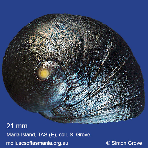
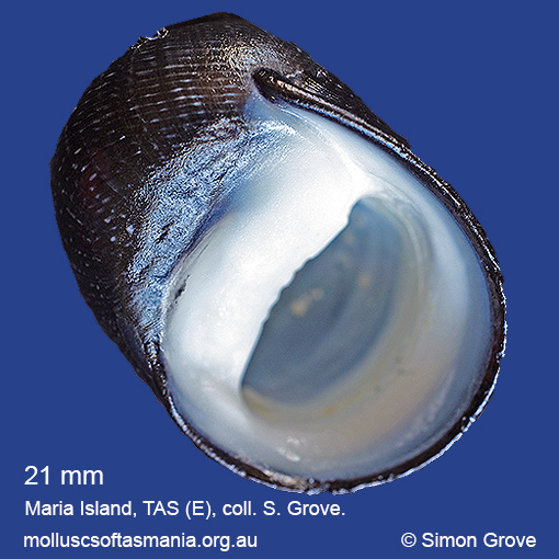
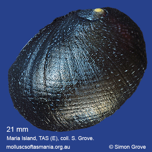
Neritidae – Neritinae: Nerita (Lisanerita) melanotragus E. A. Smith, 1884 (‘eastern black nerite’)
Synonym(s): melanotragus E. A. Smith, 1884.
Typical shell-length 25 mm. Shell generally indistinguishable from that of N. atramentosa, but the strongly brown-tinged operculum of the living animal is characteristic. Lives intertidally on rocks. Native. Occurs in eastern Australia (QLD, NSW, TAS and VIC); also New Zealand. In Tasmanian waters, this species is usually the dominant Nerita around Flinders Island and in the E, but rare or absent from the N, S and W coasts.
Classification
Class: Gastropoda
Subclass: Neritimorpha
Order: Neritimorpha – Cycloneritimorpha
Superfamily: Neritoidea
Family: Neritidae
Subfamily: Neritinae
Genus: Nerita
A-L Localities for Nerita melanotragus
Ansons Bay
Bangor: Lagoon Bay
Bangor: Two Mile Beach
Bangor: Watsons Bay
Bay of Fires: Break Yoke Beach to Pebbly Beach
Beaumaris: Shelly Point
Beerbarrel Beach
Bicheno
Bicheno: Cod Rock
Bicheno: Courland Bay
Bicheno: Diamond Island
Bicheno: Redbill Beach
Bicheno: Rice Beach
Bicheno: Waubs Beach
Binalong Bay
Binalong Bay: gulches
Blackman Bay: Little Chinaman Bay
Blackmans Bay
Boltons Beach
Bridport: East Sandy Point
Bruny Island (unlocalised)
Burnie: Blythe Heads & estuary
Cape Barren Island: Battery Bay
Cape Barren Island: Kent Bay
Cape Barren Island: Neds Point
Cape Barren Island: Rooks River mouth
Cape Barren Island: Thunder & Lightning Bay
Cape Barren Island: Tinkers Gut
Cape Barren Island (unlocalised)
Carlton: Park Beach
Chain of Lagoons: Four Mile Creek: beach
Chain of Lagoons: Piccaninny Point
Clarke Island: Black Point
Clarke Island: Black Point – beach to N
Clarke Island: Black Point – beach to S
Clarke Island: Dip Point to Black Rocks
Clarke Island: Kangaroo Bay to Seal Point
Clarke Island: Maclaines Bay
Clarke Island: Moriarty Bay
Clarke Island: South Head
Coles Bay: Bluestone Bay
Coles Bay: foreshore
Coles Bay: Gravelly Beach & Sleepy Bay
Coles Bay: Honeymoon Bay
Coles Bay: Parsons Cove
Connellys Bay
Deal Island (unlocalised)
Denison Beach: rocks at southern end
Denison Beach (unlocalised)
Dianas Beach (unlocalised)
Dunalley (unlocalised)
Eaglehawk Neck: eastern side
East Kangaroo Island: North Point
Eddystone Point: Picnic Corner
Eddystone Point (unlocalised)
Falmouth: foreshore
Falmouth: Mariposa Beach
Flinders Island: Arthur Bay: Long Point
Flinders Island: Badger Corner
Flinders Island: Big River Cove
Flinders Island: Boat Harbour Beach
Flinders Island: Emita: foreshore
Flinders Island: Emita: Old Jetty Beach
Flinders Island: Fotheringate Bay
Flinders Island: Fotheringate Beach: southern end
Flinders Island: Killiecrankie Bay (unlocalised)
Flinders Island: Killiecrankie: foreshore
Flinders Island: Lady Barron: Fisher Island
Flinders Island: Lady Barron (unlocalised)
Flinders Island: Lady Barron: Watering Beach
Flinders Island: Lady Barron: Yellow Beaches
Flinders Island: Leeka: foreshore towards Twelve Hour Point
Flinders Island: Lillies Bay
Flinders Island: Northeast River: mouth
Flinders Island: Palana Beach
Flinders Island: Patriarch Beach
Flinders Island: Port Davies & Cave Beach
Flinders Island: Sawyers Bay
Flinders Island: Sleepy Beach
Flinders Island: Spences Reef
Flinders Island: Tanners Bay
Flinders Island: Tanners Bay: Pine Scrub
Flinders Island: The Dock
Flinders Island: Trousers Point
Flinders Island (unlocalised)
Fortescue Bay
Frederick Henry Bay: Sloping Island
Freycinet Peninsula: Bryans Beach
Freycinet Peninsula: The Hazards
Freycinet Peninsula (unlocalised)
Freycinet Peninsula: Wineglass Bay
Friendly Beaches
Georges Bay: Akaroa: foreshore
Georges Bay: Blanche Point
Georges Bay: Burns Bay
Georges Bay: Humbug Point
Georges Bay: St Helens (unlocalised)
Goose Island
Greens Beach: Nudists Beach
Hogan Island
Howden: foreshore
Lat -40.5S Long 148.18E Kangaroo Bay, Clarke Island, Furneaux Group, Banks Strait
Lauderdale: Roches Beach
Lauderdale: Seven Mile Beach
Lime Bay
Lime Bay: Black Rock: beach
Little Chalky Island
Little Musselroe Bay: Lyme Regis Lagoon
Little Musselroe Bay: northern end
Little Musselroe Bay: Tree Point area
Little Swanport: Saltworks Beach
Long Island: Crayfish Point
M-Z Localities for Nerita melanotragus
Maria Island: Bloodstone Beach
Maria Island: Darlington Bay
Maria Island: Fossil Cliffs
Maria Island: Four Mile Beach
Maria Island: Gulls Nest Point
Maria Island: Howells Point & Painted Cliffs
Maria Island: Point Lesueur
Maria Island: Return Point
Maria Island: Trigonia Corner
Mayfield Beach to Mayfield Point
Mayfield Point to Little Christmas Island
Mercury Passage: Darlington Bay
Murdunna: foreshore
Musselroe Point
Narawntapu: Badger Beach
Narawntapu: Copper Cove
North Bruny Island: Roberts Point
Nubeena: Roaring Beach
Orford: Emerald Beach
Outer Sister Island
Passage Island
Pirates Bay: Fossil Island
Pirates Bay (unlocalised)
Planters Beach to Fishers Point
Port Arthur: Basket Bay: Remarkable Cave
Port Arthur: Little Possum Beach
Port Arthur: Safety Cove
Port Cygnet: Cray Point
Primrose Sands
Randalls Bay
Rheban Beach
Schouten Island: Crocketts Bay
Schouten Island: Moreys Bay
Schouten Island: Sandspit Point
Schouten Island (unlocalised)
Seymour Beach: northern end
South Bruny Island: Adventure Bay: Cemetery Bluff
South Bruny Island: Adventure Bay: Grass Point
South Bruny Island: Adventure Bay: southern end
South Bruny Island: Neck Beach: Blighs Rocks
South Bruny Island: Old Jetty Beach
South Bruny Island: Sheepwash Bay
Stanley: Godfreys Beach
St Helens Point
Swansea: Jubilee Beach
Swansea: Kelvedon Beach: Shelly Point
Swansea: Lisdillon Beach
Swansea: Spiky Beach
Swansea (unlocalised)
Swanwick: foreshore
Taroona Beach
The Gardens: beach
The Gardens: Coffeys Gulch
The Gardens: Cosy Corner
The Gardens: Mateys Gulch to Gardens Lagoon
The Gardens: Seatons Cove
The Gardens: Swimcart Beach
The Gardens: Taylors Beach
Three Hummock Island: Rape Bay
Three Hummock Island: Three Gullies Bay
Tinderbox Beach
Wykeholm Point & Bay