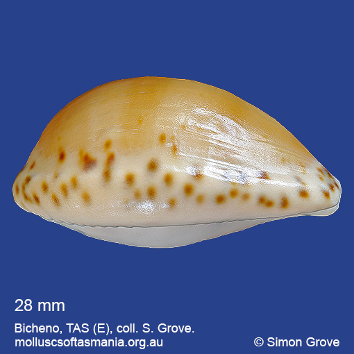
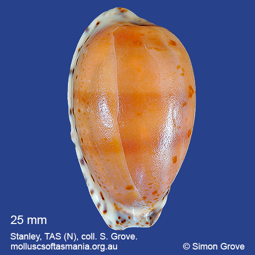
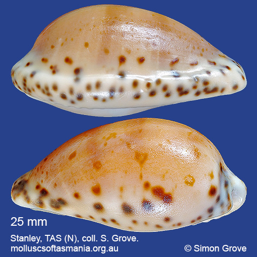
Cypraeidae – Cypraeovulinae: Notocypraea comptonii (Gray, 1847) (‘Compton’s cowrie’)
Synonym(s): comptonii Gray, 1847 mayi Beddome, 1897 trenberthae Trenberth, 1961 casta Schilder & Summers, 1963.
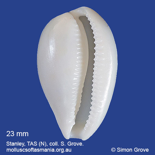
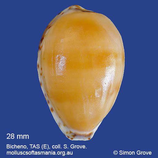
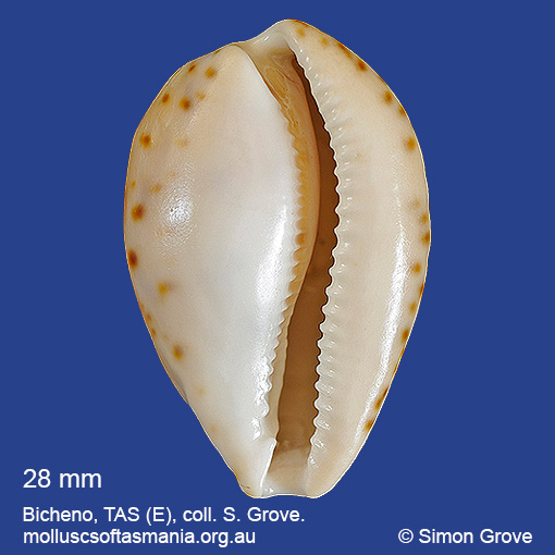
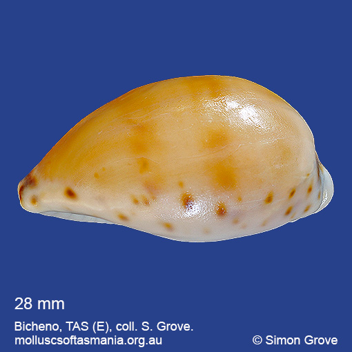
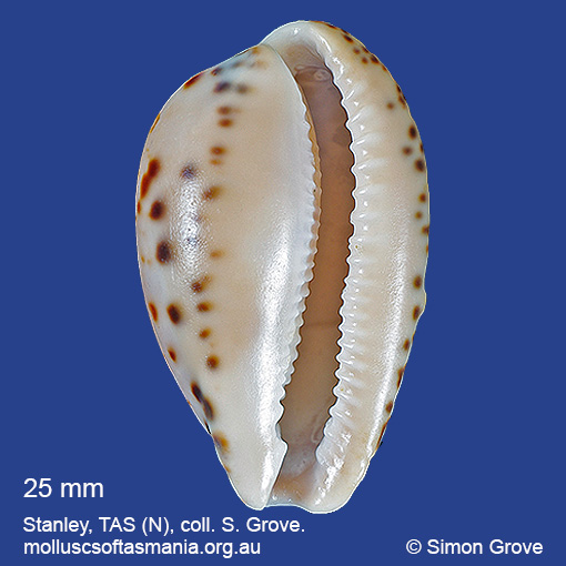
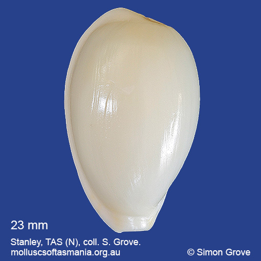
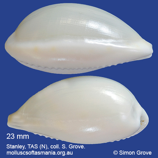
Typical shell-length 25 mm. Shell outline often narrow in specimens from the N coast, but broader elsewhere. Dorsum may be pale or dark brown, but generally bears traces of uninterrupted darker stripes, while the whole shell often has a peachy background colour. Lives subtidally under rocks and stones. Native. Endemic to southeastern and southwestern Australia (NSW, TAS, VIC, SA and WA). In Tasmanian waters, this is a widespread species; common in the N, but rare to the S.
Classification
Class: Gastropoda
Subclass: Caenogastropoda – Sorbeoconcha
Order: Hypsogastropoda – Littorinimorpha
Superfamily: Cypraeoidea
Family: Cypraeidae
Subfamily: Pustulariinae
Genus: Notocypraea
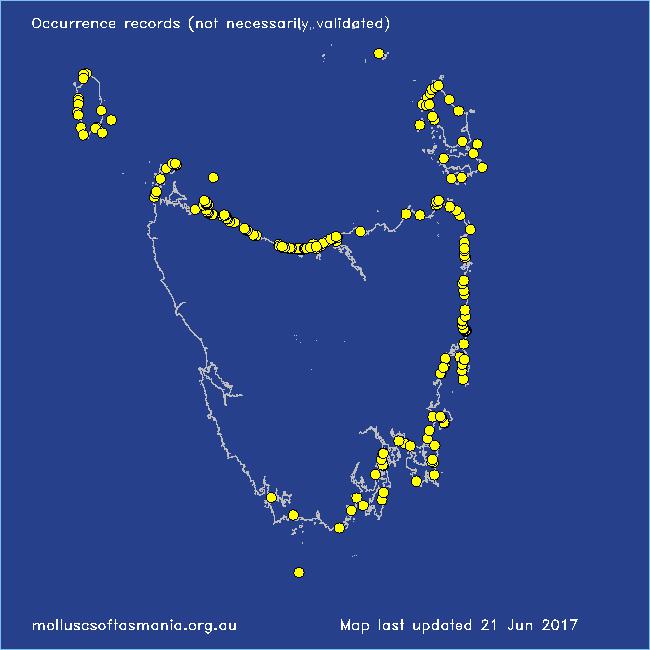
A-L Localities for Notocypraea comptonii
Bangor: Lagoon Bay
Bay of Fires: Break Yoke Beach to Pebbly Beach
Beaumaris: Shelly Point
Bicheno
Bicheno: Diamond Island
Bicheno: Redbill Beach
Bicheno: Rice Beach
Bicheno: Waubs Gulch
Blackmans Bay
Black River Beach
Black River Beach: northern end
Black River Beach: southern end
Boat Harbour: Western Bay
Cape Barren Island: SE of Tar Point
Cape Barren Island: Tinkers Gut
Cape Barren Island (unlocalised)
Cape Portland: Lanoma Point
Cape Portland: Lemons Beach
Cape Portland: Petal Point
Carlton Beach: Spectacle Island
Carlton: Park Beach
Chain of Lagoons: Four Mile Creek: beach
Chain of Lagoons: Piccaninny Point
Clarke Island: Black Point
Clarke Island: Spike Bay
Coles Bay: Muirs Beach
Coles Bay: Richardsons Beach
Cooee Beach
Cox Bight (unlocalised)
Croppies Beach: northern end
Deephole Bay
Denison Beach: Porch Rocks
Denison Beach: rocks at southern end
Denison Beach (unlocalised)
Devonport: Bluff Beach
Devonport: Coles Beach
Devonport: Mersey River
Devonport: Paradise Cove (unlocalised)
Douglas River: beach
Eaglehawk Neck: eastern side
East Devonport: Moorland Beach
East Devonport: Moorland Point
East Devonport: Pardoe Beach
East Devonport: Pardoe Point
East Ulverstone
East Ulverstone: Buttons Beach
East Wynyard: beach
Eddystone Point (unlocalised)
Falmouth: Mariposa Beach
Flinders Island: Emita: foreshore
Flinders Island: Foochow Beach
Flinders Island: Killiecrankie: foreshore
Flinders Island: Lady Barron (unlocalised)
Flinders Island: Leeka: foreshore towards Twelve Hour Point
Flinders Island: Northeast River: mouth
Flinders Island: Palana Beach
Flinders Island: Patriarch Beach
Flinders Island: Sawyers Bay
Flinders Island: Sleepy Beach
Flinders Island: Tanners Bay
Flinders Island: Tanners Bay: Pine Scrub
Flinders Island: The Dock
Fortescue Bay
Freycinet Peninsula: Cooks Beach
Freycinet Peninsula: Hazards Beach
Friendly Beaches
Goat Island: foreshore of island and nearby mainland
Great Musselroe Bay
Great Oyster Bay
Greens Beach: main beach
Greens Beach: Nudists Beach
Hawley Beach: foreshore towards Point Sorell
Hunter Island (unlocalised)
King Island: Cape Wickham: foreshore to E
King Island: Fitzmaurice Bay
King Island: Grassy Harbour
King Island: Grassy Harbour: Sandblow Bay
King Island: Halfmoon Bay
King Island: Little Porky Beach
King Island: Naracoopa: foreshore
King Island: Pass River Bay
King Island: S coast (unlocalised)
King Island: Seal Bay: Black Point
King Island (unlocalised)
King Island: Unlucky Bay
King Island: Victoria Cove
King Island: W coast
King Island: Yellow Rock Beach
Lauderdale: Seven Mile Beach
Leith: foreshore
Leith: Lillico Beach
Little Peggs Beach
Low Head: East Beach
Low Head (unlocalised)
Lulworth: Tam O”Shanter Bay
M-Z Localities for Notocypraea comptonii
=Maria Island: Return Point
Maria Island: Shoal Bay: McRaes Isthmus
Maria Island: Trigonia Corner
Marion Bay: Bream Creek foreshore
Marion Bay: northern beaches
Marion Bay (unlocalised)
Mayfield Beach to Mayfield Point
Mayfield Point to Little Christmas Island
Musselroe Point
Narawntapu: Badger Beach
Narawntapu: Bakers Beach
Narawntapu: Bakers Point & Springlawn Beach
Narawntapu: Copper Cove
Narawntapu: Griffiths Point
North Bruny Island: Dennes Point
Northdown Beach
Peggs Beach: eastern end
Peggs Beach (unlocalised)
Peggs Beach: western end
Penguin: Lonah & Lodders Point
Pirates Bay: near landing
Pirates Bay (unlocalised)
Port Davey: Schooner Cove
Port Esperance: Stringers Cove
Port Latta: Cowrie Point
Prime Seal Island: Sealers Cove
Primrose Sands
Rheban Beach
Rocky Cape: Anniversary Bay
Rocky Cape: Burgess Cove
Rocky Cape: Castle Rock Bay
Rocky Cape: foreshore N of Picnic Beach
Rocky Cape: Mary Anne Cove area
Rocky Cape: Picnic Beach & rocks to S
Rocky Cape (unlocalised)
Scamander (unlocalised)
Schouten Island: Crocketts Bay
Seymour Beach: northern end
Sisters Beach
Somerset: foreshore
South Bruny Island: Adventure Bay (unlocalised)
South Bruny Island: Butlers Beach
South coast of Tasmania (unlocalised)
Stanley: Anthony Beach
Stanley: Circular Head
Stanley: Cow Rock beach
Stanley: Godfreys Beach
Stanley: Halfmoon Bay
Stanley: Tatlows Beach
Stanley (unlocalised)
Stumpys Bay (unlocalised)
Swansea: Kelvedon Beach
Swansea: Spiky Beach
Swansea (unlocalised)
Swanwick: foreshore
Tamar River: Kelso: foreshore
Taroona: Alum Cliffs
Taroona Beach
Taroona: Hinsby Beach
Tasmania (unlocalised)
The Gardens
The Gardens: Cosy Corner
The Gardens: Mateys Gulch to Gardens Lagoon
The Gardens: Swimcart Beach
Three Hummock Island: Mermaid Bay
Three Hummock Island: Rape Bay
Three Hummock Island: Spiers Bay: Spiers Nook
Three Hummock Island: Three Gullies Bay
Three Hummock Island: Three Gullies Bay: southern end
Tomahawk Beach
Tunnel Bay
Turners Beach
West Ulverstone: foreshore
West Ulverstone: Picnic Point Beach
Woolnorth: Davisons Bay
Woolnorth: Valley Bay
Woolnorth: Woolnorth Point
Wynyard: Fossil Bluff