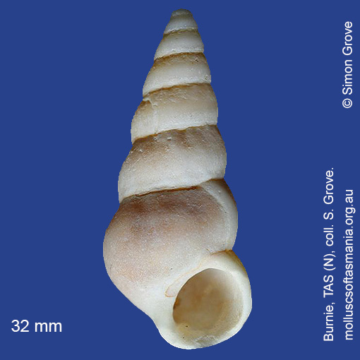
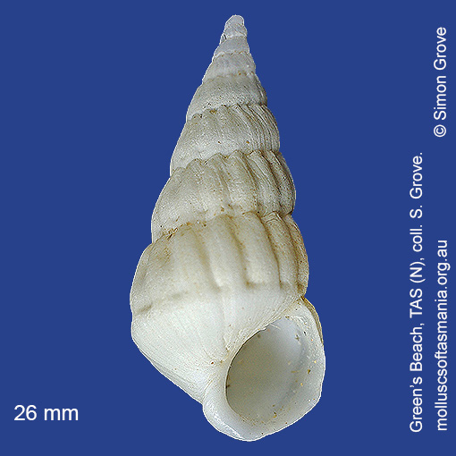
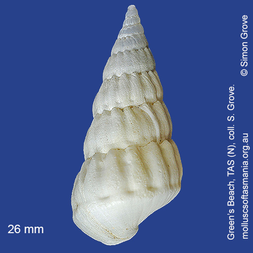
Epitoniidae: Opalia (Granuliscala) granosa (Quoy & Gaimard, 1834) (‘grainy wentletrap’)
Synonym(s): granosa Quoy & Gaimard, 1834 granulosa Sowerby, 1844 granulata Reeve, 1873.
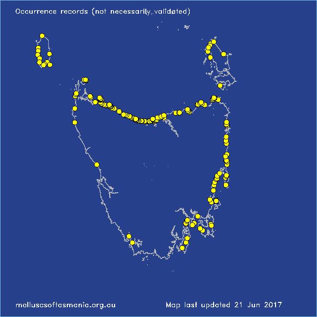
Typical shell-length 40 mm. Lives intertidally and subtidally amongst sea-anemones, in moderately exposed environments. Native. Endemic to southeastern and southwestern Australia (TAS, VIC, SA and WA). In Tasmanian waters, this is a common species in the N; rare or absent to the S.
Classification
Class: Gastropoda
Subclass: Caenogastropoda – Sorbeoconcha
Order: Hypsogastropoda – Littorinimorpha
Superfamily: Epitonioidea
Family: Epitoniidae
Genus: Opalia
A-L Localities for Opalia granosa
Arthur River: Sarah Anne Rocks
Beaumaris: Shelly Point
Bellingham
Bicheno: Courland Bay
Bicheno: Diamond Island
Bicheno: Redbill Beach
Bicheno: Rice Beach
Blackmans Bay
Black River Beach: northern end
Black River Beach: southern end
Boat Harbour: beach
Boltons Beach
Bridport: Adams Beach
Bridport: beach
Bridport: East Sandy Point
Bridport: Lades Beach
Bridport (unlocalised)
Bruny Island (unlocalised)
Burnie: Blythe Heads & estuary
Burnie: Sulphur Creek
Burnie: Titan Point
Burnie (unlocalised)
Calverts Beach & Goats Bluff
Cape Portland: Home Beach
Cape Portland: Lanoma Point
Cape Portland: Lemons Beach
Cape Portland: Petal Point
Cape Portland: Roses Bay
Carlton: Park Beach
Chain of Lagoons: Four Mile Creek: beach
Clarke Island: Dip Point to Black Rocks
Clayton: foreshore
Clifton Beach: western end
Coles Bay: Honeymoon Bay
Coles Bay (unlocalised)
Cooee Beach
Croppies Beach: northern end
Davey River: Carvers Point
Denison Beach: Porch Rocks
Devonport: Back Beach
Devonport: Bluff Beach
Devonport: Coles Beach
Devonport: Don Heads
Devonport: Mersey River
Devonport: Paradise Cove (unlocalised)
Eaglehawk Neck: eastern side
East Devonport: beach & breakwater
East Devonport: Moorland Beach
East Devonport: Moorland Point
East Devonport: Pardoe Beach
East Devonport: Pardoe Beach: The Water Rat
East Devonport: Pardoe Point
East Ulverstone
East Ulverstone: Buttons Beach
East Wynyard: beach
Edgcumbe Beach
Falmouth: foreshore
Flinders Island: Killiecrankie: foreshore
Flinders Island: Northeast River: mouth
Flinders Island: Palana Beach
Flinders Island: Patriarch Beach
Flinders Island: Port Davies & Cave Beach
Flinders Island: Tanners Bay: Pine Scrub
Flinders Island: The Dock
Freycinet Peninsula (unlocalised)
Goat Island: foreshore of island and nearby mainland
Greens Beach: main beach
Greens Beach: Nudists Beach
Hawley Beach
Hawley Beach: foreshore towards Point Sorell
Hellyer Beach
Herbies Landing
King Island: Cape Wickham: foreshore to E
King Island: Ettrick Beach
King Island: Fitzmaurice Bay
King Island: Grassy Harbour
King Island: Little Porky Beach
King Island: Naracoopa: foreshore
King Island: Pass River Bay
King Island: Red Hut Point
King Island: Seal Bay: Black Point
King Island: Seal Point
King Island (unlocalised)
Leith: foreshore
Leith: Lillico Beach
Little Musselroe Bay: Tree Point area
Little Peggs Beach
Little Swanport: Saltworks Beach
Low Head (unlocalised)
Lulworth: Tam O”Shanter Bay
M-Z Localities for Opalia granosa
Maria Island: Darlington Bay
Maria Island: Hopground Beach
Maria Island: Howells Point & Painted Cliffs
Marrawah: Green Point Beach
Mayfield Beach to Mayfield Point
Narawntapu: Badger Beach
Narawntapu: Badger Head
Narawntapu: Bakers Beach
Narawntapu: Copper Cove
Narawntapu: Griffiths Point
Narawntapu: Little Badger Head
Nine Mile Beach & Dolphin Sands
Northdown Beach
Nubeena: Roaring Beach
Nubeena: White Beach
Orford: Emerald Beach
Orford: Luther Point
Peggs Beach (unlocalised)
Peggs Beach: western end
Penguin: Johnsons Beach
Penguin: Lonah & Lodders Point
Penguin Point
Penguin to Ulverstone: foreshore
Penguin: Watcombe Beach
Pipers Head
Pirates Bay: Fossil Island
Pirates Bay: near landing
Point Sorell and foreshore to SW
Point Sorell: Margaret Rocks
Port Davey: Schooner Cove
Port Latta: Brickmakers Beach
Port Latta: Cowrie Point
Port Sorell: beach
Port Sorell (unlocalised)
Ransons Beach
Robbins Island: Cape Elie
Robbins Island: East Beach
Rocky Cape: Anniversary Bay
Rocky Cape: Burgess Cove
Rocky Cape: Castle Rock Bay
Rocky Cape: Cathedral Rocks Bay
Rocky Cape: foreshore N of Picnic Beach
Rocky Cape: Mary Anne Cove area
Rocky Cape: Picnic Beach & rocks to S
Rocky Cape (unlocalised)
Schouten Island: Crocketts Bay
Seymour Beach: northern end
Shearwater: Freers Beach
Sisters Beach
Somerset: foreshore
South Bruny Island: Adventure Bay: Cemetery Bluff
South Bruny Island: Cloudy Beaches: eastern beach
South Croppies Point
South East coast of Tasmania (unlocalised)
Stanley: Anthony Beach
Stanley: Cow Rock beach
Stanley: foreshore
Stanley: Godfreys Beach
Stanley: Halfmoon Bay
Stanley: Tatlows Beach
Stanley (unlocalised)
Swansea: Kelvedon Beach
Swansea: Kennedia Beach
Swansea: Spiky Beach
Tamar River: Kelso: foreshore
Taroona Beach
Taroona: Dixons Beach
Tasmania (unlocalised)
The Gardens: beach
The Gardens: Cosy Corner
The Gardens: Seatons Cove
The Gardens: Swimcart Beach
Three Hummock Island: Mermaid Bay
Three Hummock Island: Rape Bay
Three Hummock Island: Three Gullies Bay
Three Hummock Island: Three Gullies Bay area
Three Hummock Island: Three Gullies Bay: southern end
Tomahawk Beach
Trial Harbour
Trial Harbour area
Ulverstone (unlocalised)
Waterhouse Point
West Ulverstone: foreshore
West Ulverstone: Picnic Point: beach to W
Weymouth: beach
Woolnorth: Davisons Bay
Woolnorth: Valley Bay
Woolnorth: Woolnorth Point
Wynyard: Fossil Bluff
Wynyard (unlocalised)