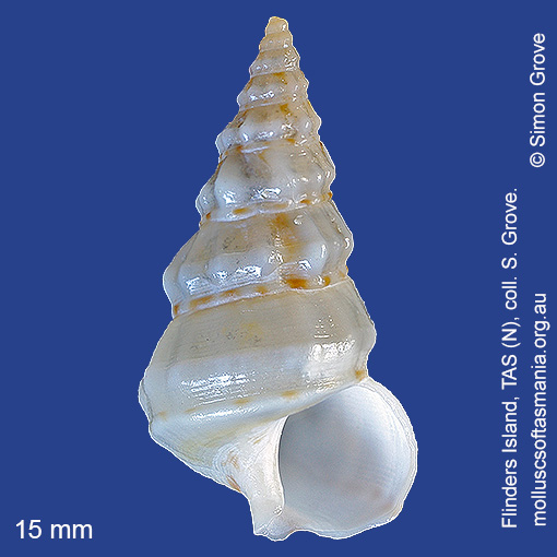
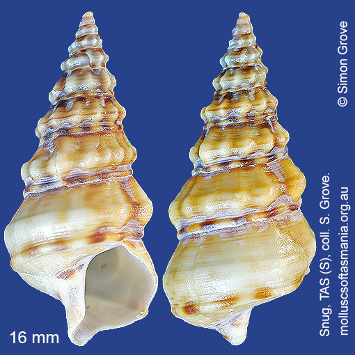
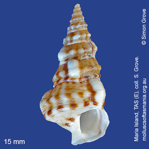
Plesiotrochidae: Plesiotrochus monachus (Crosse & Fischer, 1864) (‘common monk-shell’)
Synonym(s): monachus Crosse & Fischer, 1864.
Typical shell-length 25 mm. Lives subtidally amongst seagrass, especially in sheltered environments. Native. Endemic to southeastern and southwestern Australia (NSW, TAS, VIC, SA and WA). In Tasmanian waters, this is a widespread species, though seldom common.
Classification
Class: Gastropoda
Subclass: Caenogastropoda – Sorbeoconcha
Order: Cerithiimorpha – Cerithiimorpha
Superfamily: Campaniloidea
Family: Plesiotrochidae
Genus: Plesiotrochus
A-L Localities for Plesiotrochus monachus
Ansons Bay
Bangor: Two Mile Beach
Bellingham
Bicheno
Blackmans Bay
Black River Beach
Black River Beach: northern end
Black River Beach: southern end
Bridport: beach
Bridport: Lades Beach
Burnie: Blythe Heads & estuary
Cape Barren Island: Bungs Beach
Cape Barren Island: Kenneth Point
Carlton Beach: Spectacle Island
Carlton: Park Beach
Clayton: foreshore
Coles Bay: foreshore
Coles Bay: Honeymoon Bay
Coles Bay: Parsons Cove
Coles Bay: Richardsons Beach
Coles Bay (unlocalised)
Davey River: Carvers Point
Devonport: Bluff Beach
Devonport: Coles Beach
Devonport: Paradise Cove (unlocalised)
Dodges Ferry: Red Ochre Beach
Dover: beach
East Devonport: beach & breakwater
East Devonport: Moorland Beach
East Devonport: Pardoe Beach
East Devonport: Pardoe Point
East Kangaroo Island: North Point
East Kangaroo Island (unlocalised)
East Ulverstone
East Ulverstone: Buttons Beach
East Wynyard: beach
E coast of Tasmania (unlocalised)
Flinders Island: Arthur Bay: Long Point
Flinders Island: Badger Corner
Flinders Island: Fotheringate Bay
Flinders Island: Fotheringate Beach: southern end
Flinders Island: Lady Barron: Fisher Island
Flinders Island: Lady Barron: Yellow Beaches
Flinders Island: Leeka: foreshore towards Twelve Hour Point
Flinders Island: Lillies Bay
Flinders Island: Northeast River: mouth
Flinders Island: Parrys Bay: Double Corner
Flinders Island: Patriarch Beach
Flinders Island: Patriarch Inlet
Flinders Island: Trousers Point
Flinders Island (unlocalised)
Flinders Island: White Beach to Dick Davey Shoal
Flinders Island: Whitemark Beach
Franklin Sound area
Freycinet Peninsula: Bryans Beach
Freycinet Peninsula: Hazards Beach
Freycinet Peninsula (unlocalised)
Garden Island Sands
Goat Island: foreshore of island and nearby mainland
Greens Beach: main beach
Hawley Beach: foreshore towards Point Sorell
Howden: foreshore
King Island: Fitzmaurice Bay
King Island: Halfmoon Bay
King Island: Naracoopa: foreshore
King Island (unlocalised)
King Island: W coast
Lauderdale: Roches Beach
Lauderdale: Seven Mile Beach
Leith: foreshore
Leith: Lillico Beach
Little Musselroe Bay: Tree Point area
Low Head (unlocalised)
M-Z Localities for Plesiotrochus monachus
Macquarie Harbour: Kelly Basin
Margate: Dru Point & Nierinna Creek mouth
Maria Island: Bloodstone Point
Maria Island: Darlington Bay
Maria Island: Encampment Cove
Maria Island: Gulls Nest Point
Maria Island: Hopground Beach
Maria Island: Howells Point & Painted Cliffs
Maria Island: Shoal Bay: McRaes Isthmus
Marrawah: Green Point Beach
Mayfield Beach to Mayfield Point
Mayfield Point to Little Christmas Island
Mercury Passage: ACMA Asterias survey Stn 04
Mercury Passage: ACMA Asterias survey Stn 05
Narawntapu: Griffiths Point
Nine Mile Beach & Dolphin Sands
North coast of Tasmania (unlocalised)
Nubeena: White Beach
Orford: East Shelly Beach
Orford: Shelly Beach (unlocalised)
Orford (unlocalised)
Orford: West Shelly Beach
Peggs Beach: western end
Pipers Head
Pirates Bay (unlocalised)
Port Arthur: Big Possum Beach
Port Davey: Bond Bay
Port Davey: Whalers Cove
Port Latta: Brickmakers Beach
Port Latta: Cowrie Point
Port Sorell: beach
Primrose Sands
Rheban Beach
Robbins Island: Marys Island area
Rocky Cape: Anniversary Bay
Rocky Cape: Forwards Beach
Rocky Cape: Mary Anne Cove area
Schouten Island: Crocketts Bay
Shearwater: Freers Beach
Sloping Lagoon: Lagoon Beach
Sloping Main Beach
Smithton: Duck River mouth
Snug Beach
Somerset: foreshore
South Bruny Island: Great Taylors Bay
South Croppies Point
South East coast of Tasmania (unlocalised)
Stanley: Anthony Beach
Stanley: Circular Head
Stanley: East Inlet
Stanley: foreshore
Stanley: Green Hills: West Inlet entrance
Stanley: Halfmoon Bay
Stanley: Tatlows Beach
Stanley (unlocalised)
Stanley: West Inlet
Swansea: Jubilee Beach
Swansea (unlocalised)
Tamar Island
Tamar River: Clarence Point: foreshore
Tamar River: Kelso: foreshore
Taroona: Alum Cliffs
Taroona Beach
Taroona: Dixons Beach
Taroona: Hinsby Beach
Tasmania (unlocalised)
Three Hummock Island: Three Gullies Bay: northern end
Tinderbox Beach
Turners Beach
Walker Island
Waterhouse Island
Woolnorth: Woolnorth Point