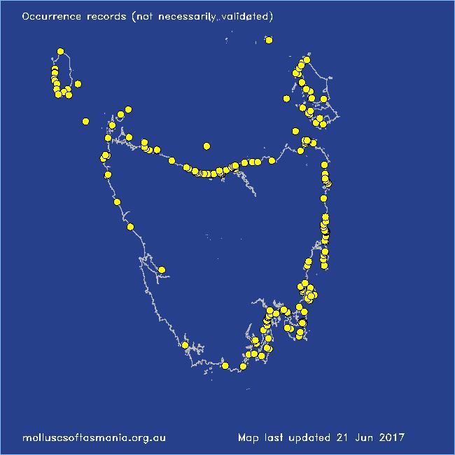
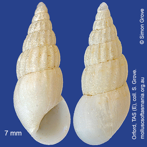
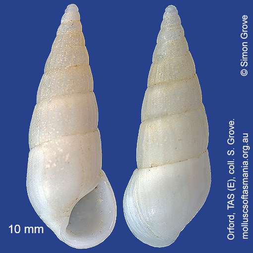
Rissoinidae: Rissoina (Rissoina) fasciata A. Adams, 1853 (‘banded rice-shell’)
Synonym(s): fasciata A. Adams, 1853 hanleyi Schwartz, 1860 flexuosa Gould, 1861 cincta Angas, 1867 smithi Angas, 1867 variegata Angas, 1867 delecta Laseron, 1956.
Typical shell-length 8.0 mm. Lives subtidally under rocks and stones. Native. Endemic to southern and eastern Australia (QLD, NSW, TAS, VIC and SA).
Classification
Class: Gastropoda
Subclass: Caenogastropoda – Sorbeoconcha
Order: Hypsogastropoda – Littorinimorpha
Superfamily: Rissooidea
Family: Rissoinidae
Genus: Rissoina
A-L Localities for Rissoina fasciata
Ansons Bay
Arthur River: Nelson Bay
Arthur River: Sarah Anne Rocks
Badger Island
Bangor: Lagoon Bay
Beechford: foreshore
Bellerive Beach
Bellingham
Bicheno: Cod Rock
Bicheno: Courland Bay
Bicheno: Redbill Beach
Bicheno: Rice Beach
Bicheno: Waubs Beach
Binalong Bay: gulches
Binalong Bay: Jeanneret Beach
Blackmans Bay
Black River Beach: northern end
Black River Beach: southern end
Bridport: beach
Burnie: Blythe Heads & estuary
Burnie: Sulphur Creek
Cape Barren Island: Bungs Beach
Cape Barren Island: Thunder & Lightning Bay
Cape Barren Island (unlocalised)
Cape Portland: Home Beach
Cape Portland: Lanoma Point
Cape Portland: Petal Point
Cape Portland: Roses Bay
Cape Portland (unlocalised)
Carlton Beach: Spectacle Island
Chain of Lagoons: Piccaninny Point
Clarke Island: Black Point
Clarke Island: Dip Point to Black Rocks
Coles Bay: foreshore
Coles Bay: Honeymoon Bay
Coles Bay: Richardsons Beach
Coles Bay (unlocalised)
Deal Island (unlocalised)
Denison Beach: Porch Rocks
Denison Beach (unlocalised)
Devonport: Bluff Beach
Devonport: Coles Beach
Devonport: Don Heads
Devonport: Mersey River
Dodges Ferry: Red Ochre Beach
Eaglehawk Neck: eastern side
East Devonport: Moorland Beach
East Devonport: Pardoe Beach
East Devonport: Pardoe Point
East Ulverstone
East Wynyard: beach
Flinders Island: Arthur Bay: Long Point
Flinders Island: Fotheringate Bay
Flinders Island: Fotheringate Beach: southern end
Flinders Island: Killiecrankie Bay (unlocalised)
Flinders Island: Killiecrankie: foreshore
Flinders Island: Lady Barron: Fisher Island
Flinders Island: Leeka: foreshore towards Twelve Hour Point
Flinders Island: Lillies Bay
Flinders Island: Northeast River: mouth
Flinders Island: Palana Beach
Flinders Island: Port Davies & Cave Beach
Flinders Island: Tanners Bay: Pine Scrub
Flinders Island: The Dock
Flinders Island (unlocalised)
Flinders Island: Whitemark Beach
Freycinet Peninsula: Cooks Beach
Freycinet Peninsula (unlocalised)
Friendly Beaches
Georges Bay: Blanche Point
Goat Island: foreshore of island and nearby mainland
Granville Harbour: coast to N
Greens Beach: main beach
Greens Beach: Nudists Beach
Hawley Beach
Hawley Beach: foreshore towards Point Sorell
Hunter Island (unlocalised)
Huon Island
Kettering: Oyster Cove
King Island: Cape Wickham: foreshore to E
King Island: Colliers Beach
King Island: Currie Harbour
King Island: Ettrick Beach
King Island: Fitzmaurice Bay
King Island: Grassy Harbour
King Island: Halfmoon Bay
King Island: Little Porky Beach
King Island: Pass River Bay
King Island: Porky Beach
King Island: Red Hut Point
King Island: Surprise Bay
King Island (unlocalised)
King Island: W coast
Lagoon River: mouth
Leith: Lillico Beach
Little Musselroe Bay: Tree Point area
Little Swanport: Saltworks Beach
Low Head: East Beach
Low Head (unlocalised)
Lulworth: Tam O”Shanter Bay
M-Z Localities for Rissoina fasciata
Macquarie Harbour: Kelly Basin
Maria Island: Bloodstone Point
Maria Island: Darlington Bay
Maria Island: Gulls Nest Point
Maria Island: Howells Point & Painted Cliffs
Maria Island: Point Lesueur
Maria Island: Return Point
Maria Island: Trigonia Corner
Marion Bay: Bream Creek foreshore
Marion Bay (unlocalised)
Marrawah: Green Point
Marrawah: Green Point Beach
Marrawah: West Point
Mayfield Point to Little Christmas Island
Narawntapu: Bakers Point & Springlawn Beach
Narawntapu: Copper Cove
Narawntapu: Griffiths Point
North Bruny Island: Little Fancy Bay
Nubeena: Roaring Beach
Okehampton Bay (unlocalised)
Orford: East Shelly Beach
Orford: Emerald Beach
Orford: Shelly Beach (unlocalised)
Orford: Spring Beach
Orford: West Shelly Beach
Penguin: Lonah & Lodders Point
Pirates Bay: Fossil Island
Pirates Bay: middle rocks
Pirates Bay (unlocalised)
Planters Beach to Fishers Point
Port Arthur: Denmans Cove
Port Cygnet: Cray Point
Port Davey: Whalers Cove
Port Latta: Cowrie Point
Port Sorell: beach
Primrose Point
Primrose Sands
Ralphs Bay (unlocalised)
Randalls Bay
Rheban Beach
Robbins Island: Marys Island area
Rocky Boat Inlet
Rocky Cape: Mary Anne Cove area
Scamander (unlocalised)
Schouten Island: Crocketts Bay
Seymour Beach: northern end
South Bruny Island: Adventure Bay: Cemetery Bluff
South Bruny Island: Adventure Bay: Grass Point
South Bruny Island: Butlers Beach
South Bruny Island: Cloudy Beaches: eastern beach
South East coast of Tasmania (unlocalised)
Southport: Sisters Bay
Stanley: Godfreys Beach
Tamar River: Kelso: foreshore
Taroona: Alum Cliffs
Taroona Beach
Taroona: Dixons Beach
Tasmania (unlocalised)
The Gardens: Coffeys Gulch
The Gardens: Mateys Gulch to Gardens Lagoon
The Gardens: Seatons Cove
The Gardens: Swimcart Beach
Three Hummock Island: Rape Bay
Tinderbox Beach
Ulverstone (unlocalised)
West Ulverstone: foreshore
Woolnorth: Valley Bay