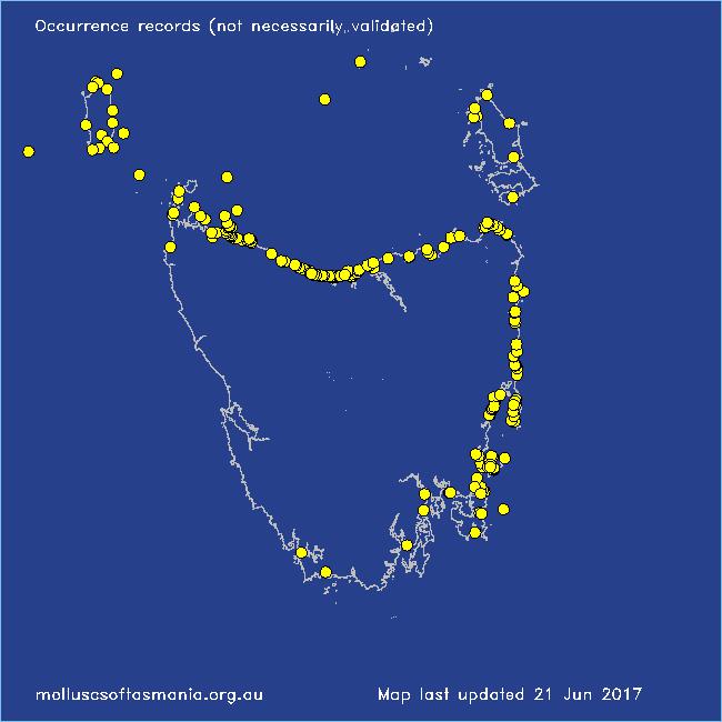
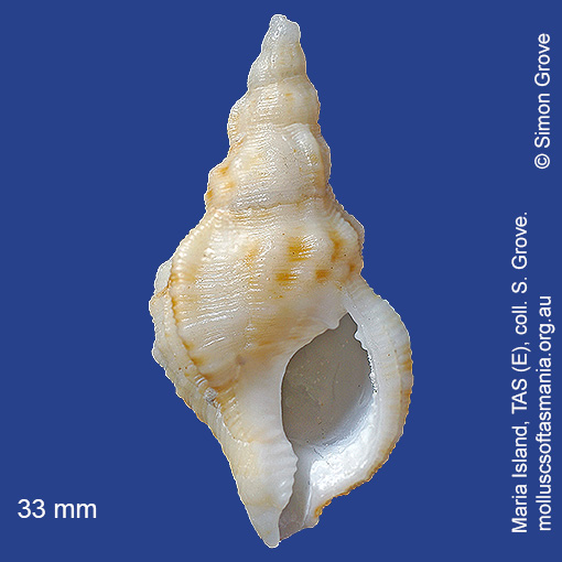
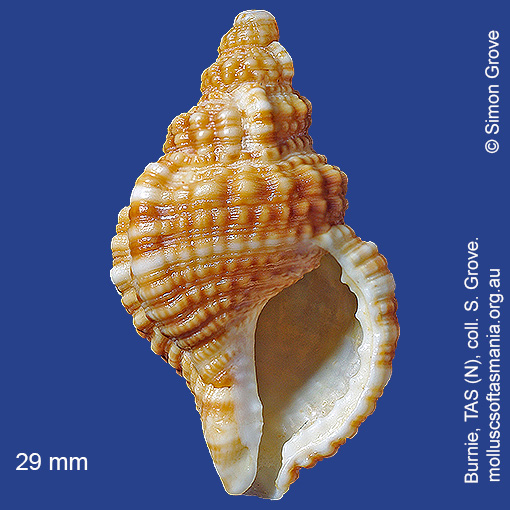
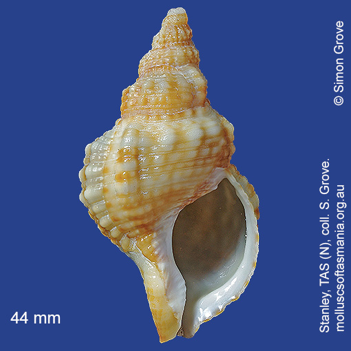
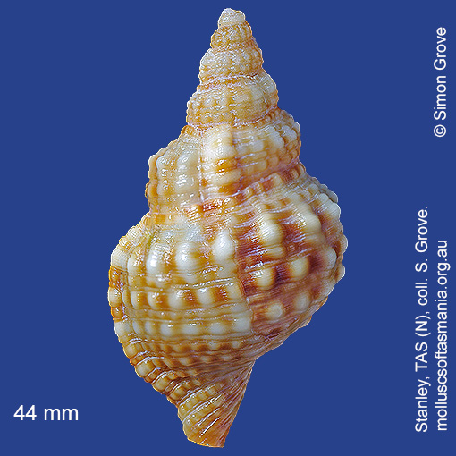
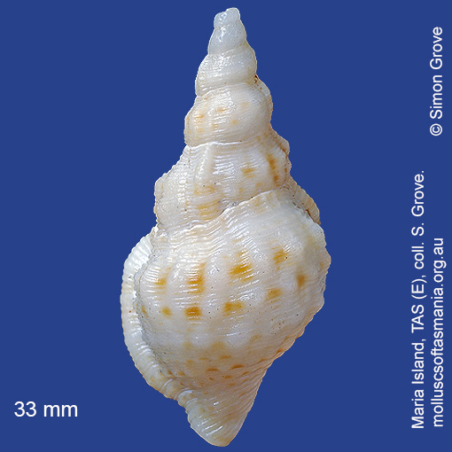
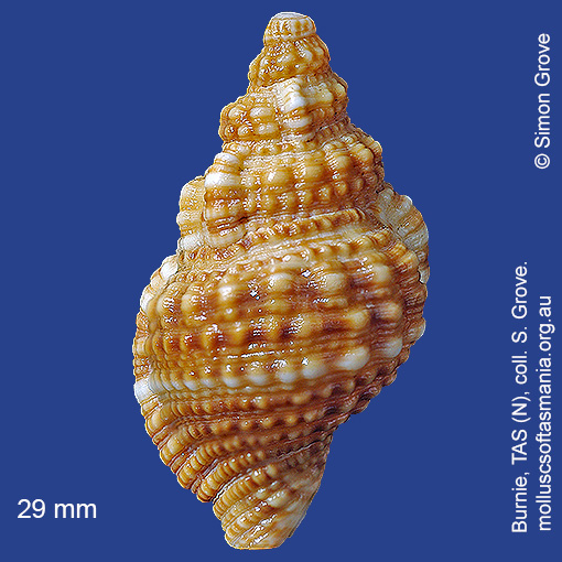
Ranellidae – Cymatiinae: Sassia (Austrotriton) subdistorta (Lamarck, 1822) (‘distorted rock-whelk’)
Synonym(s): subdistorta Lamarck, 1822 delecta Cotton, 1945.
Typical shell-length 70 mm. Variable in size, colour intensity, shape and degree of ornamentation. Lives subtidally amongst rocks and seaweed. Native. Endemic to southeastern and southwestern Australia (NSW, TAS, VIC, SA and WA). In Tasmanian waters, this is a common species in the N, where the largest shells are found; rare or absent to the S.
Classification
Class: Gastropoda
Subclass: Caenogastropoda – Sorbeoconcha
Order: Hypsogastropoda – Littorinimorpha
Superfamily: Tonnoidea
Family: Ranellidae
Subfamily: Cymatiinae
Genus: Sassia
A-L Localities for Sassia subdistorta
Bangor: Two Mile Beach
Beaumaris: Shelly Point
Beechford: foreshore
Bellingham
Bicheno: Courland Bay
Bicheno: Diamond Island
Bicheno: Rice Beach
Blackmans Bay
Black River Beach
Black River Beach: northern end
Black River Beach: southern end
Bridport: beach
Bridport: East Sandy Point
Bridport: Lades Beach
Bridport (unlocalised)
Burnie: Blythe Heads & estuary
Burnie: Sulphur Creek
Burnie: Titan Point
Cape Portland: Lanoma Point
Cape Portland: Lemons Beach
Cape Portland: Petal Point
Cape Portland: Roses Bay
Carlton Beach: Spectacle Island
Carlton: Park Beach
Chain of Lagoons: Piccaninny Point
Clarke Island: Black Point
Clayton: foreshore
Coles Bay: Parsons Cove
Coles Bay (unlocalised)
Cooee Beach
Cox Bight (unlocalised)
Croppies Beach: northern end
Curtis group (unlocalised)
Denison Beach: Porch Rocks
Denison Beach: rocks at southern end
Devonport: Bluff Beach
Devonport: Coles Beach
Devonport: Don Heads
Devonport: Mersey River
Devonport (unlocalised)
Douglas River: beach
Earlham: foreshore
East Devonport: beach & breakwater
East Devonport: Moorland Beach
East Devonport: Moorland Point
East Devonport: Pardoe Beach
East Devonport: Pardoe Point
East Ulverstone
East Ulverstone: Buttons Beach
E coast of Tasmania (unlocalised)
Falmouth: foreshore
Falmouth: Mariposa Beach
Flinders Island: Lady Barron: Fisher Island
Flinders Island: Northeast River: mouth
Flinders Island: Patriarch Beach
Flinders Island: Tanners Bay
Flinders Island: Tanners Bay: Pine Scrub
Flinders Island (unlocalised)
Freycinet Peninsula: Bryans Beach
Freycinet Peninsula: Cooks Beach
Freycinet Peninsula (unlocalised)
Freycinet Peninsula: Wineglass Bay
Georges Bay: St Helens (unlocalised)
Georges Bay (unlocalised)
Goat Island: foreshore of island and nearby mainland
Great Musselroe Bay
Great Musselroe Bay: bar
Greens Beach: main beach
Greens Beach: Nudists Beach
Hawley Beach: foreshore towards Point Sorell
Hellyer Beach
Hobart: Sullivans Cove area
Hunter Island: Cave Bay
Hunter Island: Shepherds Bay
Huon Island
King Island: Cape Wickham: foreshore to E
King Island: City of Melbourne Bay
King Island: Disappointment Bay
King Island: Grassy Harbour
King Island: Lavinia Beach: beach nr Lake Martha Lavinia
King Island: Naracoopa: foreshore
King Island: S coast (unlocalised)
King Island: Sea Elephant Bay: Cowper Point
King Island: Seal Bay: Black Point
King Island: Seal Point
King Island (unlocalised)
King Island: Yellow Rock Beach
Leith: foreshore
Leith: Lillico Beach
Little Musselroe Bay: northern end
Little Musselroe Bay: Tree Point area
Little Peggs Beach
Low Head (unlocalised)
M-Z Localities for Sassia subdistorta
Maria Island: Bloodstone Beach
Maria Island: Darlington Bay
Maria Island: Gulls Nest Point
Maria Island: Oyster Bay
Maria Island: Point Lesueur
Maria Island: Return Point
Maria Island: Riedlé Bay: McRaes Isthmus
Maria Island: Shoal Bay: McRaes Isthmus
Maria Island: Trigonia Corner
Marion Bay: Bream Creek foreshore
Marion Bay: northern beaches
Marion Bay (unlocalised)
Marrawah: Green Point Beach
Mayfield Beach to Mayfield Point
Mayfield Point to Little Christmas Island
Musselroe Point
Narawntapu: Bakers Beach
Narawntapu: Bakers Point & Springlawn Beach
Narawntapu: Copper Cove
Narawntapu: Griffiths Point
Narawntapu: Little Badger Head
Nine Mile Beach & Dolphin Sands
Northdown Beach
North West coast of Tasmania (unlocalised)
Orford: East Shelly Beach
Orford: Millingtons Beach
Orford: Spring Beach
Peggs Beach: eastern end
Peggs Beach (unlocalised)
Peggs Beach: western end
Penguin: Johnsons Beach
Penguin: Lonah & Lodders Point
Penguin Point
Pipers Head
Pirates Bay: Fossil Island
Pirates Bay (unlocalised)
Point Sorell and foreshore to SW
Point Sorell: Margaret Rocks
Port Davey: Schooner Cove
Port Latta: Brickmakers Beach
Port Latta: Cowrie Point
Port Sorell: beach
Ransons Beach
Rheban Beach
Robbins Island: East Beach
Robbins Island: Ransonnet Bay
Rocky Cape: Burgess Cove
Rocky Cape: Castle Rock Bay
Rocky Cape: Cathedral Rocks Bay
Rocky Cape: foreshore N of Picnic Beach
Rocky Cape: Forwards Beach
Rocky Cape: Mary Anne Cove area
Rocky Cape: Picnic Beach & rocks to S
Rocky Cape (unlocalised)
Scamander: Wrinklers Beach
Schouten Island: Crocketts Bay
Schouten Island: Moreys Bay
Schouten Island: Sandspit Point
Seymour Beach: northern end
Smithton: Duck Bay: Picnic Point
Smithton: Duck River mouth
Somerset: foreshore
Stanley: Anthony Beach
Stanley: Circular Head
Stanley: East Inlet
Stanley: foreshore
Stanley: Godfreys Beach
Stanley: Green Hills: West Inlet entrance
Stanley: Halfmoon Bay
Stanley: Perkins Bay & West Inlet
Stanley: Tatlows Beach
Stanley (unlocalised)
Stanley: West Inlet
St Helens Point
Swansea: Jubilee Beach
Swansea: Kelvedon Beach
Swansea: Kelvedon Beach: Shelly Point
Swansea: Kennedia Beach
Swansea: Meredith River: mouth
Swansea: Spiky Beach
Tamar River: heads
Tamar River: Kelso: foreshore
Tasmania (unlocalised)
The Gardens: Swimcart Beach
The Gardens: Taylors Beach
Turners Beach
Ulverstone (unlocalised)
Walker Island
West Ulverstone: foreshore
West Ulverstone: Picnic Point: beach to W
Woolnorth: Davisons Bay
Woolnorth: Woolnorth Point
Wynyard: Fossil Bluff