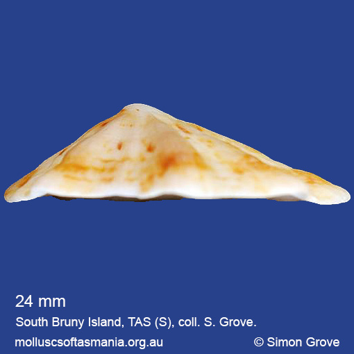
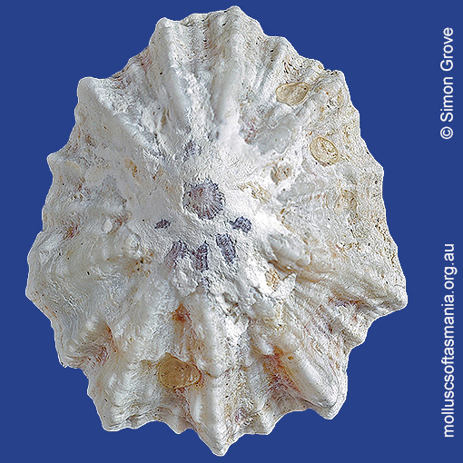
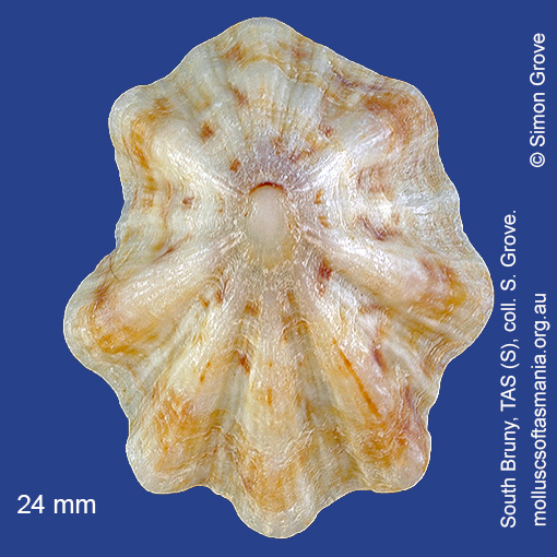
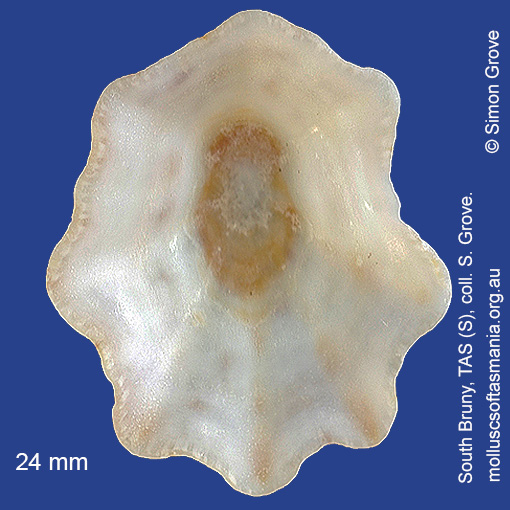
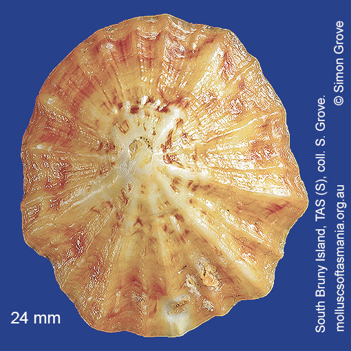
Patellidae: Scutellastra chapmani (Tenison-Woods, 1876) (‘Chapman’s limpet’)
Synonym(s): chapmani Tenison-Woods, 1876 alba Tenison-Woods, 1877 perplexa Pilsbry, 1891.
Typical shell-length 25 mm. Specimens from the N and mainland Australia tend to have strong ribs and deeply dissected shells, whereas those from further S are more weakly ribbed, making them difficult to distinguish from small specimens of P. peronii. Lives intertidally and subtidally attached to rocks, especially on moderately sheltered shores. Native. Endemic to southeastern and southwestern Australia (NSW, TAS, VIC, SA and WA). In Tasmanian waters, this is a widespread species, but not common outside the N and NE.
Classification
Class: Gastropoda
Subclass: Patellogastropoda
Order: Patellogastropoda
Superfamily: Patelloidea
Family: Patellidae
Genus: Scutellastra
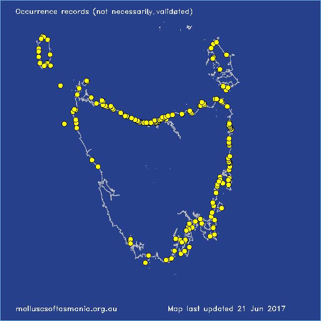
A-L Localities for Scutellastra chapmani
Arthur River: Arthur Beach
Arthur River: Nelson Bay
Bangor: Lagoon Bay
Beaumaris: Shelly Point
Beechford: foreshore
Bellingham
Bicheno: Courland Bay
Bicheno: Diamond Island
Bicheno: Redbill Beach
Bicheno: Waubs Beach
Binalong Bay
Binalong Bay: beach
Binalong Bay: gulches
Blackmans Bay
Black River Beach: northern end
Black River Beach: southern end
Boltons Beach
Bridport: Adams Beach
Bridport: beach
Bridport: East Sandy Point
Bridport (unlocalised)
Brooks Bay: White Bluff
Burnie: Blythe Heads & estuary
Cape Portland: Lanoma Point
Cape Portland: Roses Bay
Cape Portland (unlocalised)
Carlton: Park Beach
Chain of Lagoons: Four Mile Creek: beach
Clarke Island: Black Point
Clarke Island: Dip Point to Black Rocks
Clarke Island: Maclaines Bay
Clarke Island: Moriarty Bay
Cockle Creek Bay
Coles Bay: Honeymoon Bay
Cooee Beach
Croppies Beach: northern end
Davey River: Carvers Point
Denison Beach: Porch Rocks
Denison Beach: rocks at southern end
Denison Beach (unlocalised)
Devonport: Back Beach
Devonport: Bluff Beach
Devonport: Coles Beach
Devonport: Don Heads
Devonport: Paradise Cove (unlocalised)
Douglas River: beach
Eaglehawk Neck: eastern side
East Devonport: beach & breakwater
East Devonport: Moorland Beach
East Devonport: Pardoe Beach
East Devonport: Pardoe Point
East Ulverstone
East Ulverstone: Buttons Beach
Falmouth: foreshore
Falmouth: Mariposa Beach
Flinders Island: Emita: foreshore
Flinders Island: Fotheringate Bay
Flinders Island: Killiecrankie Bay (unlocalised)
Flinders Island: Killiecrankie: foreshore
Flinders Island: Leeka: foreshore towards Twelve Hour Point
Flinders Island: Lillies Bay
Flinders Island: Northeast River: mouth
Flinders Island: Palana Beach
Flinders Island: Patriarch Beach
Flinders Island: Trousers Point
Fortescue Bay
Frederick Henry Bay: Sloping Island
Freycinet Peninsula: Bryans Beach
Freycinet Peninsula: The Hazards
Freycinet Peninsula (unlocalised)
Freycinet Peninsula: Wineglass Bay
Friendly Beaches
Georges Bay: Blanche Point
Goat Island: foreshore of island and nearby mainland
Granville Harbour
Granville Harbour: coast to N
Great Musselroe Bay
Greens Beach: main beach
Greens Beach: Nudists Beach
Hawley Beach: foreshore towards Point Sorell
Hellyer Beach
Hunter Island (unlocalised)
King Island: Cape Wickham: foreshore to E
King Island: Colliers Beach
King Island: Disappointment Bay
King Island: Fitzmaurice Bay
King Island: Grassy Harbour
King Island: Grassy Harbour: Sandblow Bay
King Island: Halfmoon Bay
King Island: Lavinia Beach: beach nr Lake Martha Lavinia
King Island: Little Porky Beach
King Island: Naracoopa: foreshore
King Island: Pass River Bay
King Island: Seal Bay: Black Point
King Island: Seal Point
King Island: Yellow Rock Beach
Lauderdale: Roches Beach
Leith: Lillico Beach
Little Coningham Beach
Little Musselroe Bay: Tree Point area
Louisa Bay
Low Head: Bellbuoy Beach
Low Head (unlocalised)
M-Z Localities for Scutellastra chapmani
Maatsuyker Island
Marion Bay: Bream Creek foreshore
Marion Bay: northern beaches
Marion Bay (unlocalised)
Marrawah: Green Point
Marrawah (unlocalised)
Marrawah: West Point
Mayfield Beach to Mayfield Point
Narawntapu: Badger Beach
Narawntapu: Bakers Beach
Narawntapu: Copper Cove
Narawntapu: Griffiths Point
Narawntapu: Little Badger Head
Narawntapu: West Head
Ninepin Point
North Bruny Island: Dennes Point
North coast of Tasmania (unlocalised)
Northdown Beach
Orford: Spring Beach
Peggs Beach (unlocalised)
Penguin: Johnsons Beach
Penguin: Lonah & Lodders Point
Pipers Head
Pirates Bay: middle rocks
Pirates Bay (unlocalised)
Planters Beach to Fishers Point
Point Sorell: Margaret Rocks
Port Arthur: Safety Cove
Port Davey: Bond Bay
Port Davey: Whalers Cove
Port Latta: Brickmakers Beach
Port Latta: Cowrie Point
Port Sorell: beach
Randalls Bay
Ransons Beach
Rheban Beach
Robbins Island: East Beach
Rocky Cape: Anniversary Bay
Rocky Cape: Castle Rock Bay
Rocky Cape: foreshore N of Picnic Beach
Rocky Cape: Mary Anne Cove area
Rocky Cape: Picnic Beach & rocks to S
Rocky Cape (unlocalised)
Seymour Beach: northern end
Shearwater: Freers Beach
Sisters Beach
Somerset: foreshore
South Arm: beach
South Bruny Island: Adventure Bay: Grass Point
South Bruny Island: Adventure Bay: southern end
South Bruny Island: Cloudy Beaches: eastern beach
South Bruny Island: Lighthouse Bay
South Cape Rivulet: mouth
South Croppies Point
Southport: Roaring Beach
Stanley: Anthony Beach
Stanley: Godfreys Beach
Stumpys Bay (unlocalised)
Swansea: Cressy Beach
Swansea: Kelvedon Beach
Swansea: Lisdillon Beach
Swansea: Spiky Beach
Swansea (unlocalised)
Tamar River: Kelso: foreshore
Taroona Beach
Taroona: Dixons Beach
Tasmania (unlocalised)
Temma
The Gardens: beach
The Gardens: Cosy Corner
The Gardens: Mateys Gulch to Gardens Lagoon
The Gardens: Swimcart Beach
The Gardens: Taylors Beach
Three Hummock Island: Mermaid Bay
Three Hummock Island: Three Gullies Bay
Tinderbox: Bellendena: foreshore
Trial Harbour
Trial Harbour area
Turners Beach
Waterhouse Island
Waterhouse Point
West Ulverstone: foreshore
West Ulverstone: Picnic Point: beach to W
Woolnorth: Woolnorth Point
Wynyard: Fossil Bluff
Wynyard (unlocalised)