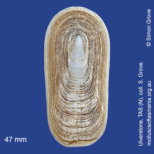
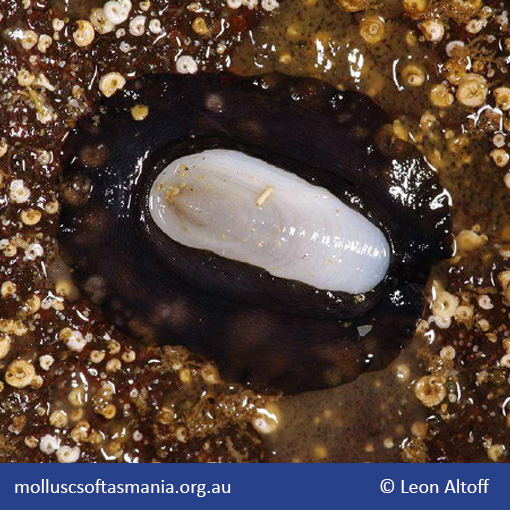
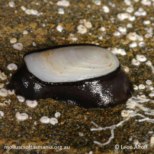
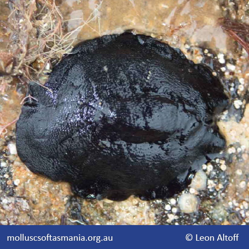
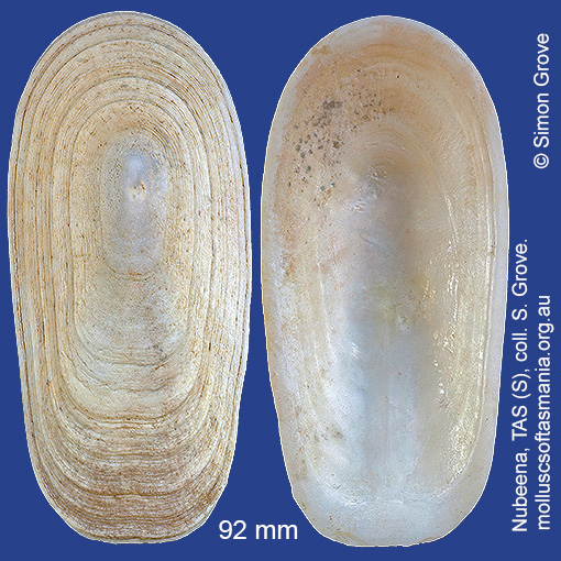
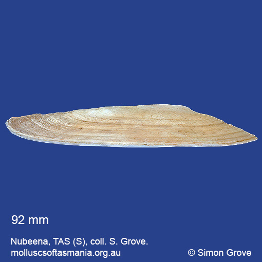
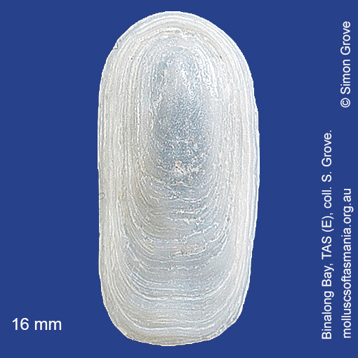
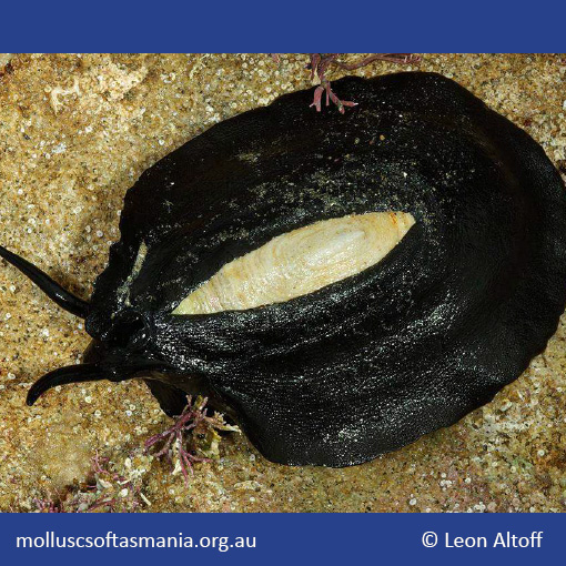
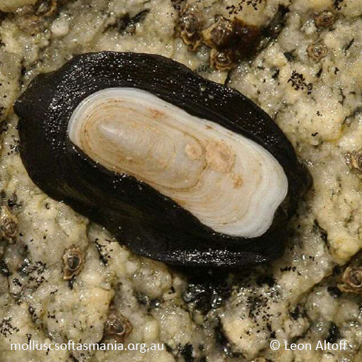
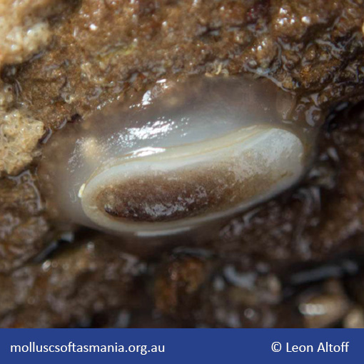
Fissurellidae – Emarginulinae: Scutus (Scutus) antipodes Montfort, 1810 (‘common elephant-snail’)
Synonym(s): antipodes Montfort, 1810 anatinus Donovan, 1820 veitchi Cotton, 1953.
Typical shell-length 110 mm. The shell sits atop a much larger, jet-black animal. Lives intertidally and subtidally under rocks and stones, especially in moderately exposed environments, emerging onto exposed rock surfaces at night. Native. Endemic to southeastern and southwestern Australia (NSW, TAS, VIC, SA and WA). In Tasmanian waters, this is a widespread and often common species.
Classification
Class: Gastropoda
Subclass: Vetigastropoda
Order: Vetigastropoda
Superfamily: Fissurelloidea
Family: Fissurellidae
Subfamily: Emarginulinae
Genus: Scutus
Subclass: Vetigastropoda
Order: Vetigastropoda
Superfamily: Fissurelloidea
Family: Fissurellidae
Subfamily: Emarginulinae
Genus: Scutus
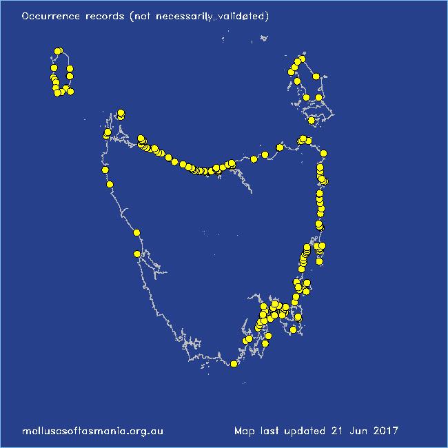
A-L Localities for Scutus antipodes
Arthur River: Sundown Point
Bay of Fires: Break Yoke Beach to Pebbly Beach
Beaumaris: Shelly Point
Beerbarrel Beach
Bicheno
Bicheno: Diamond Island
Bicheno: Redbill Beach
Bicheno: Waubs Beach
Binalong Bay: beach
Binalong Bay: gulches
Blackmans Bay
Black River Beach: northern end
Black River Beach: southern end
Boat Harbour: beach
Boltons Beach
Bridport: East Sandy Point
Burnie: Titan Point
Cape Portland: Lemons Beach
Cape Portland: Petal Point
Cape Portland: Roses Bay
Carlton Beach: Spectacle Island
Carlton: Park Beach
Chain of Lagoons: Four Mile Creek: beach
Chain of Lagoons: Little Beach
Chain of Lagoons: Piccaninny Point
Clarke Island: Maclaines Bay
Clayton: foreshore
Clifton Beach (unlocalised)
Clifton Beach: western end
Coles Bay: Honeymoon Bay
Coles Bay (unlocalised)
Coningham Beach
Coningham: foreshore
Connellys Bay
Cremorne: foreshore
Croppies Beach: northern end
Denison Beach: rocks at southern end
Denison Beach (unlocalised)
Devonport: Bluff Beach
Devonport: Coles Beach
Devonport: Don Heads
Dover: beach
Dover: Roaring Bay Beach
Eaglehawk Neck: eastern side
Earlham: foreshore
East Devonport: beach & breakwater
East Devonport: Moorland Beach
East Devonport: Moorland Point
East Devonport: Pardoe Beach
East Devonport: Pardoe Beach: The Water Rat
East Devonport: Pardoe Point
East Ulverstone
East Ulverstone: Buttons Beach
Eddystone Point: Cod Bay: George Rocks
Falmouth: foreshore
Flinders Island: Killiecrankie: foreshore
Flinders Island: Lady Barron: Fisher Island
Flinders Island: Leeka: foreshore towards Twelve Hour Point
Flinders Island: Northeast River: mouth
Flinders Island: Palana Beach
Flinders Island: Patriarch Beach
Flinders Island: Port Davies & Cave Beach
Flinders Island: Trousers Point
Flinders Island (unlocalised)
Frederick Henry Bay: Sloping Island
Freycinet Peninsula (unlocalised)
Freycinet Peninsula: Wineglass Bay
Georges Bay: Blanche Point
Goat Island: foreshore of island and nearby mainland
Greens Beach: Friend Point
Greens Beach: main beach
Greens Beach: Nudists Beach
Hawley Beach: foreshore towards Point Sorell
Hellyer Beach
Hobart (unlocalised)
Kettering: Oyster Cove
King Island: British Admiral Beach
King Island: Cape Wickham: foreshore to E
King Island: Ettrick Beach
King Island: Fitzmaurice Bay
King Island: Grassy Harbour
King Island: Grassy Harbour: Sandblow Bay
King Island: Naracoopa: foreshore
King Island: Pass River Bay
King Island: S coast (unlocalised)
King Island: Sea Elephant Bay: Cowper Point
King Island: Seal Bay: Black Point
King Island: Seal Point
King Island (unlocalised)
King Island: Victoria Cove
Kingston Beach
Lauderdale: Bambra Reef
Lauderdale: Roches Beach
Lauderdale: Seven Mile Beach
Leith: foreshore
Leith: Lillico Beach
Leven River: mouth
Lime Bay
Lime Bay: Green Head
Little Musselroe Bay: Tree Point area
Low Head (unlocalised)
M-Z Localities for Scutus antipodes
Maria Island: Darlington Bay
Maria Island: Encampment Cove
Maria Island: Fossil Cliffs
Maria Island: Trigonia Corner
Marion Bay: Bream Creek foreshore
Marion Bay: northern beaches
Mayfield Beach to Mayfield Point
Narawntapu: Copper Cove
Narawntapu: Griffiths Point
North Bruny Island: Cape Queen Elizabeth
North Bruny Island: Dennes Point
North coast of Tasmania (unlocalised)
Orford: Luther Point
Orford: Shelly Beach (unlocalised)
Penguin: Johnsons Beach
Penguin: Lonah & Lodders Point
Penguin Point
Pipers Head
Pirates Bay: Fossil Island
Pirates Bay (unlocalised)
Point Sorell and foreshore to SW
Port Arthur: Safety Cove
Port Latta: Brickmakers Beach
Port Latta: Cowrie Point
Port Sorell (unlocalised)
Primrose Sands
Rheban Beach
Rocky Cape: Castle Rock Bay
Rocky Cape: foreshore N of Picnic Beach
Rocky Cape: Mary Anne Cove area
Scamander: Wrinklers Beach
Schouten Island: Crocketts Bay
Sisters Beach
Sloping Lagoon: Lagoon Beach
Sloping Main: Black Jack Point
Smiths Gulch
Somerset: foreshore
South Arm: Fort Beach
South Arm: Hope Beach: southern end
South Bruny Island: Adventure Bay: Grass Point
South coast of Tasmania (unlocalised)
South Croppies Point
South East coast of Tasmania (unlocalised)
Stanley: Circular Head
Stanley: East Inlet
Stanley: foreshore
Stanley: Godfreys Beach
Stanley: Halfmoon Bay
Stanley: Tatlows Beach
Stanley (unlocalised)
Strahan: Cape Sorell
Swansea: Coswell Beach
Swansea: Cressy Beach
Swansea: Jubilee Beach
Swansea: Kelvedon Beach: Shelly Point
Swansea: Lisdillon Beach
Swansea: Spiky Beach
Swansea (unlocalised)
Swanwick: foreshore
Tamar River: George Town: She Oak Point area
Tamar River: Kelso: foreshore
Taroona: Alum Cliffs
Taroona Beach
Taroona: Dixons Beach
Tasmania (unlocalised)
The Gardens: Cosy Corner
The Gardens: Mateys Gulch to Gardens Lagoon
The Gardens: Seatons Cove
The Gardens: Swimcart Beach
Three Hummock Island: East Telegraph Beach
Three Hummock Island: Mermaid Bay
Three Hummock Island: Three Gullies Bay
Tinderbox Beach
Trial Harbour
Trial Harbour area
Turners Beach
West Ulverstone: foreshore
Woodbridge: foreshore & Birchs Point
Woolnorth: Davisons Bay
Woolnorth: Valley Bay
Woolnorth: Woolnorth Point
Wynyard: Fossil Bluff
Wynyard (unlocalised)