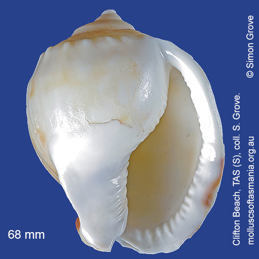
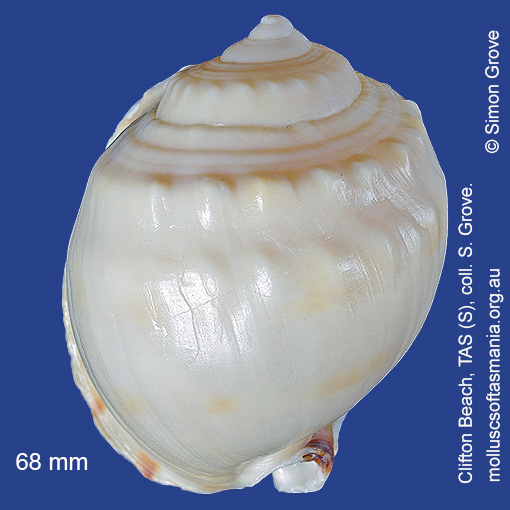
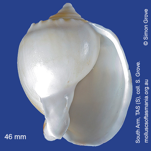
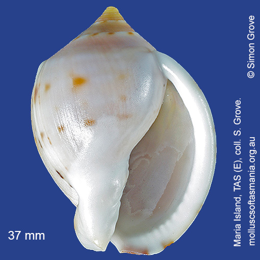
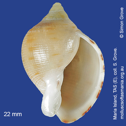
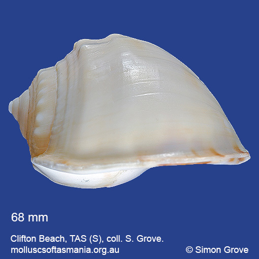
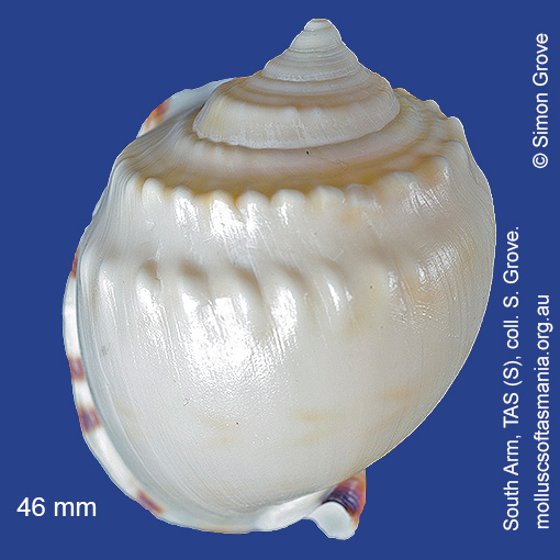
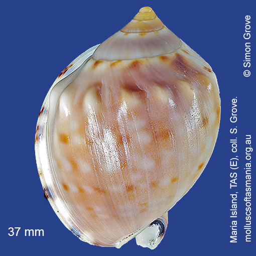
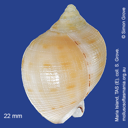
Cassidae: Semicassis (Semicassis) pyrum (Lamarck, 1822) (‘pear helmet’)
Synonym(s): pyrum Lamarck, 1822 niveum Brazier, 1872 stadiale Hedley, 1914 spectabilis Iredale, 1929 denda Cotton, 1945 mawsoni Cotton, 1945 lalli Cotton, 1954.
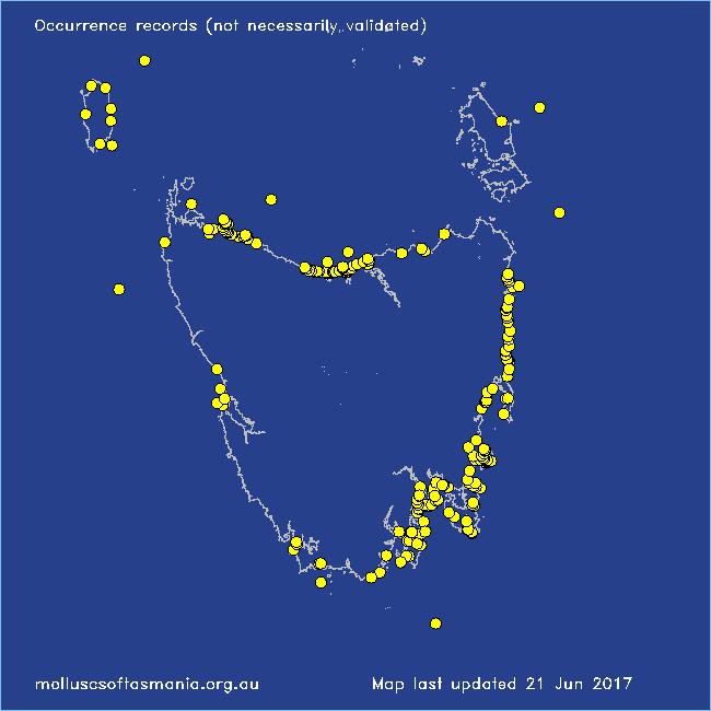
Typical shell-length 70 mm. Shell variable in size, thickness and in extent to which shoulders bear nodules. Lives subtidally and offshore on sand. Native. Occurs in southeastern and southwestern Australia (NSW, TAS, VIC, SA and WA); also New Zealand and South Africa. In Tasmanian waters, this is a widespread species; most common in the N.
Classification
Class: Gastropoda
Subclass: Caenogastropoda – Sorbeoconcha
Order: Hypsogastropoda – Littorinimorpha
Superfamily: Tonnoidea
Family: Cassidae
Subfamily: Cassinae
Genus: Semicassis
Localities for Semicassis pyrum
Bangor: Lagoon Bay
Bangor: Two Mile Beach
Beaumaris: Shelly Point
Bicheno
Bicheno: Courland Bay
Bicheno: Diamond Island
Bicheno: Redbill Beach
Bicheno: Waubs Beach
Blackman Bay: Little Chinaman Bay
Blackmans Bay
Black River Beach
Black River Beach: northern end
Black River Beach: southern end
Boat Harbour: beach
Bridport: beach
Bridport: Lades Beach
Bridport (unlocalised)
Bruny Island: E coast (unlocalised)
Bruny Island: Neck Beach
Bruny Island (unlocalised)
Calverts Beach & Goats Bluff
Carlton Beach: Spectacle Island
Carlton: Park Beach
Chain of Lagoons
Chain of Lagoons: Four Mile Creek: beach
Chain of Lagoons: Little Beach
Chain of Lagoons: Piccaninny Point
Clayton: foreshore
Clifton Beach: eastern end
Clifton Beach (unlocalised)
Clifton Beach: western end
Cox Bight (unlocalised)
Cremorne: foreshore
Croppies Beach: northern end
Denison Beach: Porch Rocks
Denison Beach: rocks at southern end
Denison Beach (unlocalised)
D’Entrecasteaux Channel (unlocalised)
Derwent channel
Devonport: Bluff Beach
Devonport: Mersey River
Devonport (unlocalised)
Dianas Beach (unlocalised)
Douglas River: beach
Eaglehawk Neck: eastern side
Earlham: foreshore
East Devonport: beach & breakwater
East Devonport: Moorland Beach
East Devonport: Moorland Point
East Devonport: Pardoe Beach
East Devonport: Pardoe Beach: The Water Rat
East Devonport: Pardoe Point
East Ulverstone
East Ulverstone: Buttons Beach
Falmouth: foreshore
Falmouth: Mariposa Beach
Flinders Island: Patriarch Beach
Freycinet Peninsula: The Hazards
Freycinet Peninsula (unlocalised)
Freycinet Peninsula: Wineglass Bay
Friendly Beaches
Georges Bay: Blanche Point
Goat Island: foreshore of island and nearby mainland
Great Oyster Bay
Greens Beach: main beach
Hawley Beach
Hawley Beach: foreshore towards Point Sorell
Hellyer Beach
King Island: Colliers Beach
King Island: Lavinia Beach: beach nr Lake Martha Lavinia
King Island: Little Porky Beach
King Island: Naracoopa: foreshore
King Island: Sea Elephant Bay: Cowper Point
King Island: Seal Bay: Black Point
King Island: Yellow Rock Beach
Kingston Beach
Lauderdale: Roches Beach
Lauderdale: Seven Mile Beach
Leith: foreshore
Leith: Lillico Beach
Little Peggs Beach
Low Head: Lagoon Beach
Low Head (unlocalised)
Maria Island: Bloodstone Beach
Maria Island: Chinamans Bay
Maria Island: Coxswain Creek: foreshore
Maria Island: Darlington Bay
Maria Island: Hopground Beach
Maria Island: Oyster Bay
Maria Island: Point Lesueur
Maria Island: Return Point
Maria Island: Riedlé Bay: McRaes Isthmus
Maria Island: Riedlé Bay (unlocalised)
Maria Island: Shoal Bay: McRaes Isthmus
Maria Island: Trigonia Corner
Marion Bay: Bream Creek foreshore
Marion Bay: northern beaches
Marion Bay (unlocalised)
Marrawah: Green Point
Mayfield Beach to Mayfield Point
Narawntapu: Badger Beach
Narawntapu: Bakers Beach
Narawntapu: Bakers Point & Springlawn Beach
Narawntapu: Copper Cove
Narawntapu: Griffiths Point
Nine Mile Beach & Dolphin Sands
North Bruny Island: Dennes Point
North Bruny Island: Killora Bay
North Bruny Island: Miles Beach
North coast of Tasmania (unlocalised)
Northdown Beach
Nubeena: Roaring Beach
Nubeena: White Beach
Orford (unlocalised)
Peggs Beach: eastern end
Peggs Beach (unlocalised)
Peggs Beach: western end
Penguin: Lonah & Lodders Point
Pirates Bay: Fossil Island
Pirates Bay (unlocalised)
Planters Beach to Fishers Point
Point Sorell and foreshore to SW
Point Sorell: Margaret Rocks
Port Arthur (unlocalised)
Port Davey: Bramble Cove
Port Davey: Schooner Cove
Port Sorell: beach
Port Sorell (unlocalised)
Primrose Beach to Carlton Bluff
Randalls Bay
Rheban Beach
Rocky Cape: Burgess Cove
Rocky Cape: Castle Rock Bay
Rocky Cape: foreshore N of Picnic Beach
Rocky Cape: Forwards Beach
Rocky Cape: Mary Anne Cove area
Rocky Cape: Picnic Beach & rocks to S
Rocky Cape (unlocalised)
Scamander (unlocalised)
Scamander: Wrinklers Beach
Schouten Island: Sandspit Point
Seymour Beach: northern end
Shearwater: Freers Beach
Smithton: Duck Bay: Picnic Point
Smithton: Duck River mouth
South Arm: Fort Beach
South Arm: Hope Beach: southern end
South Arm Neck: northern side
South Bruny Island: Adventure Bay: Cemetery Bluff
South Bruny Island: Adventure Bay: Grass Point
South Bruny Island: Alonnah Beach
South Bruny Island: Cloudy Beaches: eastern beach
South Bruny Island: Cloudy Beaches: western beach
South Bruny Island: Lighthouse Bay
South coast of Tasmania (unlocalised)
Southport: Roaring Beach
Stanley: Anthony Beach
Stanley: East Inlet
Stanley: foreshore
Stanley: Godfreys Beach
Stanley: Green Hills: West Inlet entrance
Stanley: Halfmoon Bay
Stanley: Tatlows Beach
Stanley (unlocalised)
Stephens Bay
Strahan: Macquarie Heads
Swansea: Kelvedon Beach
Swansea: Spiky Beach
Tamar River: Kelso: foreshore
Taroona Beach
Taroona: Hinsby Beach
Tasmania (unlocalised)
The Gardens: beach
The Gardens: Cosy Corner
The Gardens: Swimcart Beach
The Gardens: Taylors Beach
Tinderbox: Fossil Cove
Trial Harbour
Trial Harbour area
Turners Beach
Walker Island
West Ulverstone: foreshore
Weymouth: beach