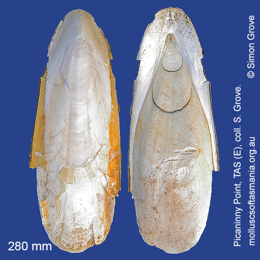
Sepiidae: Sepia apama Gray, 1849 (‘giant cuttlefish’)
Synonym(s): apama Gray, 1849 palmata Owen, 1881 parysatis Iredale, 1954.
Typical shell-length 300 mm. As with all cuttlefishes, the ‘shell’ is the animal’s rigid but buoyant internal support structure, which floats to the surface once the animal dies and may drift many kilometres before beaching. Lives in inshore waters in midwater. Native. Endemic to southeastern and southwestern Australia (QLD, NSW, TAS, VIC, SA and WA). In Tasmanian waters, this is a widespread species; common in the N, but rare to the S.
Classification
Class: Cephalopoda
Subclass: Coleoidea
Order: Sepiida
Superfamily: Sepiida – unplaced
Family: Sepiidae
Genus: Sepia
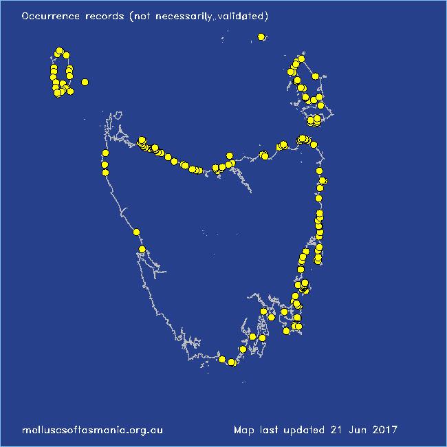
Localities for Sepia apama
Arthur River: Sarah Anne Rocks
Arthur River (unlocalised)
Bangor: Lagoon Bay
Bangor: Tasman Bay
Bangor: Two Mile Beach
Bangor: Watsons Bay
Beerbarrel Beach
Bicheno: Courland Bay
Bicheno: Diamond Island
Bicheno: Redbill Beach
Black River Beach: northern end
Black River Beach: southern end
Boat Harbour: beach
Boltons Beach
Boltons Bluff: cove to NW
Bridport: East Sandy Point
Bridport: Lades Beach
Bridport: St Albans Bay
Bruny Island: Neck Beach
Burnie: Blythe Heads & estuary
Burnie: Sulphur Creek
Calverts Beach & Goats Bluff
Cape Barren Island: Kenneth Point
Cape Portland: Home Beach
Cape Portland: Lemons Beach
Cape Portland: Petal Point
Cape Portland: Roses Bay
Chain of Lagoons: Piccaninny Point
Clarke Island: Black Point – beach to N
Clarke Island: Black Point – beach to S
Clarke Island: Dip Point to Black Rocks
Clarke Island: Kangaroo Bay to Seal Point
Clarke Island: Maclaines Bay
Clarke Island: Shevo Bay (north end)
Clarke Island: Spike Bay
Clayton: foreshore
Coles Bay: foreshore
Croppies Beach: northern end
Denison Beach: Porch Rocks
Denison Beach: rocks at southern end
Dianas Beach (unlocalised)
East Devonport: Pardoe Beach: The Water Rat
East Ulverstone: Buttons Beach
Erith Island
Falmouth: foreshore
Flinders Island: Arthur Bay: Long Point
Flinders Island: Beach S of Big River Road
Flinders Island: Emita: foreshore
Flinders Island: Fotheringate Beach: southern end
Flinders Island: Killiecrankie: foreshore
Flinders Island: Lady Barron: Watering Beach
Flinders Island: Lady Barron: Yellow Beaches
Flinders Island: Leeka: foreshore towards Twelve Hour Point
Flinders Island: Lillies Bay
Flinders Island: Northeast River: mouth
Flinders Island: Palana Beach
Flinders Island: Parrys Bay: Double Corner
Flinders Island: Patriarch Beach
Flinders Island: Port Davies & Cave Beach
Flinders Island: Tanners Bay: Pine Scrub
Flinders Island: The Dock
Flinders Island: Trousers Point: beach
Fortescue Bay
Freycinet Peninsula: Bryans Beach
Freycinet Peninsula (unlocalised)
Friendly Beaches
Georges Bay: Blanche Point
Goat Island: foreshore of island and nearby mainland
Greens Beach: main beach
Hawley Beach: foreshore towards Point Sorell
Hellyer Beach
Herbies Landing
King Island: Cape Wickham: foreshore to E
King Island: City of Melbourne Bay
King Island: Colliers Beach
King Island: Currie Harbour
King Island: Disappointment Bay
King Island: Ettrick Beach
King Island: Fitzmaurice Bay
King Island: Grassy Harbour
King Island: Grassy Harbour: Sandblow Bay
King Island: Lavinia Beach: beach nr Lake Martha Lavinia
King Island: Little Porky Beach
King Island: Naracoopa: foreshore
King Island: Pass River Bay
King Island: Sea Elephant Bay: Blowhole
King Island: Sea Elephant Bay: Cowper Point
King Island: Seal Bay: Black Point
King Island: Seal Point
King Island: Stokes Point: Gulchway
King Island: Surprise Bay
King Island (unlocalised)
King Island: Yellow Rock Beach
Leith: foreshore
Lime Bay
Little Musselroe Bay: Lyme Regis Lagoon
Little Musselroe Bay: northern end
Little Musselroe Bay: Tree Point area
Little Peggs Beach
Little Swanport: Saltworks Beach
Low Head: East Beach
Maria Island: Bloodstone Beach
Maria Island: Coxswain Creek: foreshore
Maria Island: Darlington Bay
Maria Island: Four Mile Beach
Maria Island: Hopground Beach
Maria Island: Point Lesueur
Maria Island: Return Point
Maria Island: Soldiers Beach
Maria Island: Trigonia Corner
Marion Bay: Bream Creek foreshore
Marion Bay: northern beaches
Marion Bay (unlocalised)
Marrawah: Green Point Beach
Mayfield Beach to Mayfield Point
Musselroe Point
Narawntapu: Bakers Beach
Narawntapu: Bakers Point & Springlawn Beach
Narawntapu: Copper Cove
Narawntapu: Little Badger Head
Orford: Emerald Beach
Osmiridium Beach
Peggs Beach: eastern end
Peggs Beach: western end
Pirates Bay: Fossil Island
Pirates Bay (unlocalised)
Point Sorell and foreshore to SW
Port Arthur: Denmans Cove
Port Arthur: Stinking Bay
Ransons Beach
Rocky Cape: Burgess Cove
Rocky Cape: Castle Rock Bay
Rocky Cape: Cathedral Rocks Bay
Rocky Cape: Cave Bay
Rocky Cape: Forwards Beach
Rocky Cape: Mary Anne Cove area
Rocky Cape: northern coves
Rocky Cape: Picnic Beach & rocks to S
Rocky Cape (unlocalised)
Schouten Island: Moreys Bay
Schouten Island: Sandspit Point
Seymour Beach: northern end
Sisters Beach
Somerset: foreshore
South Cape Bay: Lion Rock: beach to SE
South Cape Rivulet: mouth
Southport: Roaring Beach
Stanley: Godfreys Beach
Stanley: Green Hills: West Inlet entrance
Stanley: Tatlows Beach
Strahan: Ocean Beach
Swansea: Spiky Beach
Taroona Beach
Tasmania (unlocalised)
The Gardens: Mateys Gulch to Gardens Lagoon
Trial Harbour
Tunnel Bay
Verona Sands
Waterhouse Point
Wynyard: Fossil Bluff