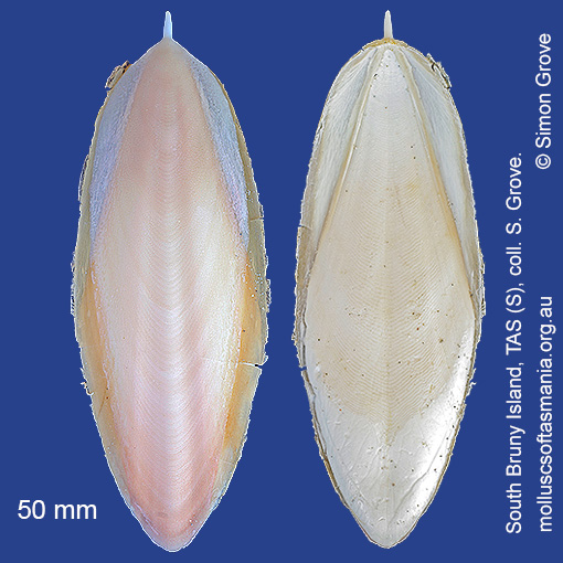
Sepiidae: Sepia hedleyi Berry, 1918 (‘Hedley’s cuttlefish’)
Synonym(s): hedleyi Berry, 1918 rex Iredale, 1926 cottesloensis Cotton, 1929 jaenschi Cotton, 1931.
Typical shell-length 55 mm. As with all cuttlefishes, the ‘shell’ is the animal’s rigid but buoyant internal support structure, which floats to the surface once the animal dies and may drift many kilometres before beaching. Lives in offshore waters in midwater. Native. Endemic to southeastern and southwestern Australia (TAS, VIC, SA and WA). In Tasmanian waters, this is a widespread and common species.
Classification
Class: Cephalopoda
Subclass: Coleoidea
Order: Sepiida
Superfamily: Sepiida – unplaced
Family: Sepiidae
Genus: Sepia
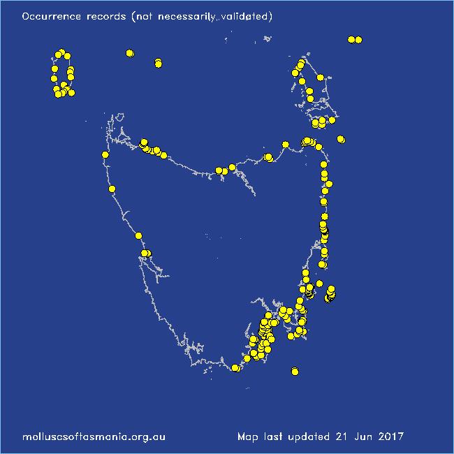
Localities for Sepia hedleyi
Ansons Bay
Bangor: Lagoon Bay
Bangor: Tasman Bay
Bangor: Two Mile Beach
Beerbarrel Beach
Bicheno: Cod Rock
Bicheno: Courland Bay
Bicheno: Diamond Island
Bicheno: Redbill Beach
Bicheno: Rice Beach
Bicheno: Waubs Beach
Blackmans Bay
Black River Beach: southern end
Boat Harbour: beach
Boltons Beach
Boltons Bluff: cove to NW
Bridport: Adams Beach
Bridport: East Sandy Point
Bridport: St Albans Bay
Bruny Island: Neck Beach
Calverts Beach & Goats Bluff
Cape Barren Island: Petticoat Bay
Cape Portland: Home Beach
Cape Portland: Lemons Beach
Cape Portland: Petal Point
Cape Portland: Roses Bay
Carlton: Park Beach
Chain of Lagoons: Piccaninny Point
Clarke Island: Black Point – beach to S
Clarke Island: Dip Point to Black Rocks
Clarke Island: Kangaroo Bay to Seal Point
Clarke Island: Spike Bay
Coles Bay (unlocalised)
Coningham: foreshore
Connellys Bay
Denison Beach: Porch Rocks
Denison Beach: rocks at southern end
Denison Beach (unlocalised)
Devonport: Don Heads
Dianas Beach (unlocalised)
Dover: Roaring Bay Beach
Eaglehawk Neck: eastern side
Eaglehawk Neck: western side
East Devonport: Pardoe Beach: The Water Rat
East Ulverstone
Falmouth: foreshore
Falmouth: Mariposa Beach
Flinders Island: Emita: foreshore
Flinders Island: Killiecrankie: foreshore
Flinders Island: Leeka: foreshore towards Twelve Hour Point
Flinders Island: Leeka: West End Beach
Flinders Island: Palana Beach
Flinders Island: Parrys Bay (unlocalised)
Flinders Island: Patriarch Beach
Flinders Island: The Dock
Fortescue Bay
Frederick Henry Bay: Sloping Island
Freycinet Peninsula: Wineglass Bay
Friendly Beaches
Garden Island Sands
Greenes Creek: beach
Greens Beach: main beach
Hawley Beach: foreshore towards Point Sorell
Hellyer Beach
Howden: foreshore
Kettering: Oyster Cove
Kettering: Trial Bay
King Island: City of Melbourne Bay
King Island: Colliers Beach
King Island: Currie Harbour
King Island: Disappointment Bay
King Island: Fitzmaurice Bay
King Island: Grassy Harbour
King Island: Grassy Harbour: Sandblow Bay
King Island: Lavinia Beach: beach nr Lake Martha Lavinia
King Island: Naracoopa: foreshore
King Island: Pass River Bay
King Island: Sea Elephant Bay: Blowhole
King Island: Sea Elephant Bay: Cowper Point
King Island: Seal Bay: Black Point
King Island: Seal Point
King Island: Surprise Bay
King Island: Yellow Rock Beach
Little Musselroe Bay: northern end
Little Musselroe Bay: Tree Point area
Little Peggs Beach
Margate: Dru Point & Nierinna Creek mouth
Maria Island: Bloodstone Beach
Maria Island: Bloodstone Point
Maria Island: Chinamans Bay
Maria Island: Coxswain Creek: foreshore
Maria Island: Darlington Bay
Maria Island: Fossil Cliffs
Maria Island: Four Mile Beach
Maria Island: Hopground Beach
Maria Island: Return Point
Maria Island: Trigonia Corner
Marion Bay: Bream Creek foreshore
Marion Bay: northern beaches
Marion Bay (unlocalised)
Mayfield Beach to Mayfield Point
Musselroe Point
Narawntapu: Bakers Beach
Narawntapu: Copper Cove
North Bruny Island: Apollo Bay
North Bruny Island: Barnes Bay
North Bruny Island: Dennes Point
North Bruny Island: Ford Bay
North Bruny Island: Great Bay: Smoothys Point
North Bruny Island: Killora Bay
North Bruny Island: Miles Beach
North Bruny Island: Quarantine Bay
Ocean Beach
Orford: Emerald Beach
Orford: Millingtons Beach
Osmiridium Beach
Peggs Beach: eastern end
Peggs Beach: western end
Pirates Bay (unlocalised)
Point Sorell and foreshore to SW
Port Arthur: Denmans Cove
Port Arthur: Safety Cove
Port Arthur: Stinking Bay
Port Cygnet: Sandrock Bay
Randalls Bay
Rocky Cape: Castle Rock Bay
Rocky Cape: Forwards Beach
Rocky Cape: Mary Anne Cove area
Rocky Cape: northern coves
Schouten Island: Crocketts Bay
Schouten Island: Moreys Bay
Schouten Island: Sandspit Point
Sloping Lagoon: Lagoon Beach
Sloping Main Beach
Snug Beach
South Arm: Fort Beach
South Arm: Hope Beach: southern end
South Bruny Island: Adventure Bay: southern end
South Bruny Island: Alonnah: Sunset Bay
South Bruny Island: Butlers Beach
South Bruny Island: Cloudy Beaches: eastern beach
South Bruny Island: Hopwood Beach
South Bruny Island: Lunawanna: Daniels Bay
South Bruny Island: Old Jetty Beach
South Bruny Island: Old Jetty Beach: beaches to N
South Bruny Island: Sheepwash Bay
South Bruny Island: Simpsons Bay: southern end
South Cape Bay: Lion Rock: beach to SE
South Cape Rivulet: mouth
Southport Bluff: beach
Stanley: Godfreys Beach
Stanley: Green Hills: West Inlet entrance
Stanley: Tatlows Beach
Strahan (unlocalised)
Taroona Beach
Taroona: Dixons Beach
Tasmania (unlocalised)
The Gardens: Mateys Gulch to Gardens Lagoon
The Gardens: Seatons Cove
Triabunna: Plain Place Beach
Trial Harbour
Tunnel Bay
Verona Sands
Waterhouse Island
Woodbridge: foreshore & Birchs Point