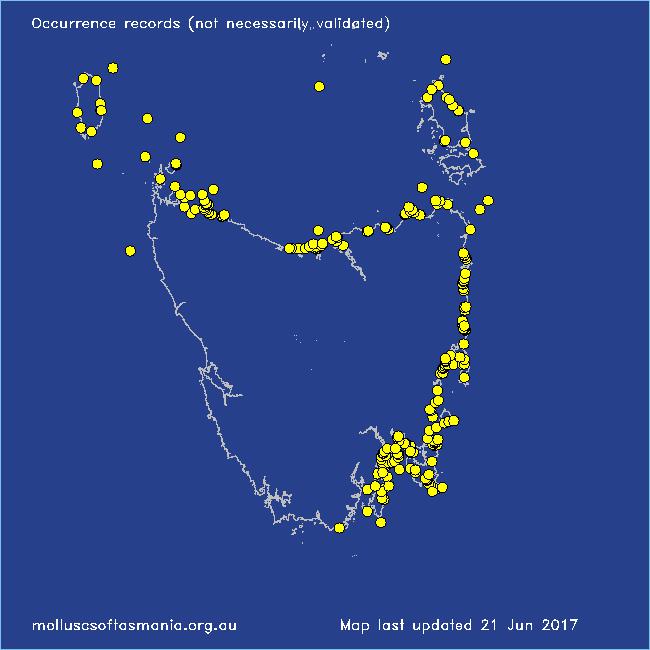
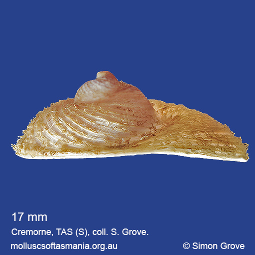
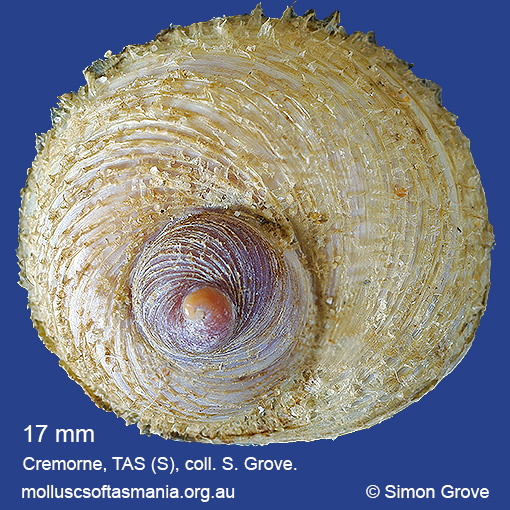
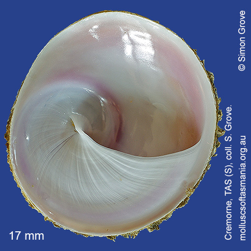
Calyptraeidae: Sigapatella calyptraeformis (Lamarck, 1822) (‘common shelf-limpet’)
Synonym(s): calyptraeformis Lamarck, 1822 tomentosa Quoy & Gaimard, 1835.
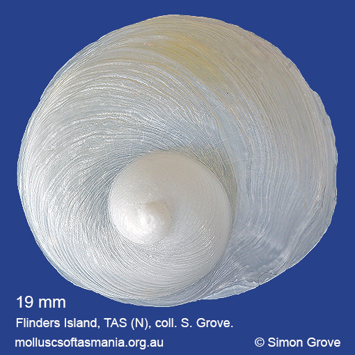
Typical shell-length 25 mm. Members of this family have an internal shelf or ledge on the underside, representing the shell’s true aperture. In this species, the periostracum is persistent but eventually wears off empty shells. Whorls convex, spire asymmetrical. Lives subtidally atttached to stones and the shells of living molluscs, especially in sheltered environments. Native. Endemic to southeastern and southwestern Australia (NSW, TAS, VIC, SA and WA). In Tasmanian waters, this is a widespread and often common species.
Classification
Class: Gastropoda
Subclass: Caenogastropoda – Sorbeoconcha
Order: Hypsogastropoda – Littorinimorpha
Superfamily: Calyptraeoidea
Family: Calyptraeidae
Genus: Sigapatella
A-L Localities for Sigapatella calyptraeformis
Bangor: Lagoon Bay
Bangor: Two Mile Beach
Beaumaris Beach
Beaumaris: Shelly Point
Bellingham
Bicheno
Bicheno: Diamond Island
Bicheno: Redbill Beach
Binalong Bay
Binalong Bay: beach
Blackmans Bay
Black River Beach: northern end
Black River Beach: southern end
Boltons Beach
Bridport: Adams Beach
Bridport: beach
Bridport: Lades Beach
Bridport (unlocalised)
Bruny Island: E coast (unlocalised)
Bruny Island: Neck Beach
Bruny Island (unlocalised)
Calverts Beach & Goats Bluff
Cape Barren Island: SE of Tar Point
Cape Portland: Lemons Beach
Cape Portland: Roses Bay
Cape Portland (unlocalised)
Carlton Beach: Spectacle Island
Carlton: Park Beach
Chain of Lagoons
Chain of Lagoons: Piccaninny Point
Clifton Beach (unlocalised)
Clifton Beach: western end
Coles Bay (unlocalised)
Cremorne: foreshore
Cremorne: Pipe Clay Lagoon
Croppies Beach: northern end
Croppies Point
Denison Beach: Porch Rocks
Denison Beach: rocks at southern end
Denison Beach (unlocalised)
D’Entrecasteaux Channel (unlocalised)
Derwent Estuary: ACMA Asterias survey Stn 20
Derwent Estuary: ACMA Asterias survey Stn 27
Derwent Estuary: ACMA Asterias survey Stn 28
Derwent Estuary: ACMA Asterias survey Stn 29
Derwent Estuary: ACMA Asterias survey Stn 31
Devonport: Bluff Beach
Dianas Beach (unlocalised)
Douglas River: beach
East Devonport: Moorland Beach
Eastern Frederick Henry Bay: ACMA Asterias survey Stn 16
Eddystone Point (unlocalised)
Falmouth: foreshore
Falmouth: Mariposa Beach
Flinders Island: E coast (unlocalised)
Flinders Island: Foochow Beach
Flinders Island: Foochow Inlet
Flinders Island: Fotheringate Bay
Flinders Island: Fotheringate Beach: southern end
Flinders Island: Killiecrankie Bay (unlocalised)
Flinders Island: Northeast River: mouth
Flinders Island: Palana Beach
Flinders Island: Patriarch Beach
Flinders Island: Patriarch Inlet
Flinders Island: Trousers Point
Flinders Island: White Beach to Dick Davey Shoal
Freycinet Peninsula (unlocalised)
Freycinet Peninsula: Wineglass Bay
Friendly Beaches
Greens Beach: main beach
Hawley Beach: foreshore towards Point Sorell
Herbies Landing
Hunter Island: Cave Bay
King Island: Colliers Beach
King Island: Fitzmaurice Bay
King Island: Lavinia Beach: beach nr Lake Martha Lavinia
King Island: Naracoopa: foreshore
King Island: Sea Elephant Bay: Blowhole
King Island (unlocalised)
King Island: Yellow Rock Beach
Kingston Beach
Lauderdale: Roches Beach
Lauderdale: Seven Mile Beach
Leith: Lillico Beach
Lime Bay: Green Head
Little Musselroe Bay: Tree Point area
Little Peggs Beach
Low Head: East Beach
Low Head (unlocalised)
M-Z Localities for Sigapatella calyptraeformis
Maria Island: Trigonia Corner
Marion Bay: Bream Creek foreshore
Marion Bay: northern beaches
Marion Bay (unlocalised)
Mayfield Beach to Mayfield Point
Mercury Passage: ACMA Asterias survey Stn 07
Midway Point (unlocalised)
Narawntapu: Bakers Beach
Narawntapu: Bakers Point & Springlawn Beach
Narawntapu: Griffiths Point
Narawntapu: Little Badger Head
Nine Mile Beach & Dolphin Sands
Norfolk Bay: Lime Bay: ACMA Asterias survey Stn 19
North Bruny Island: Bull Bay
North Bruny Island: Miles Beach
North Bruny Island: Quarantine Bay
North coast of Tasmania (unlocalised)
Nubeena: Roaring Beach
Nubeena: White Beach
Orford: Shelly Beach (unlocalised)
Orford: Spring Beach
Peggs Beach (unlocalised)
Peggs Beach: western end
Pipers Head
Pirates Bay (unlocalised)
Pitt Water (unlocalised)
Port Arthur: Denmans Cove
Port Arthur: Safety Cove
Port Sorell: beach
Port Sorell (unlocalised)
Primrose Sands
Ransons Beach
Rheban Beach
Robbins Island: East Beach
Robbins Island: Ransonnet Bay
Rocky Cape: foreshore N of Picnic Beach
Rocky Cape: Forwards Beach
Rocky Cape: Picnic Beach & rocks to S
Rocky Cape (unlocalised)
Scamander: Steels Beach
Scamander (unlocalised)
Scamander: Wrinklers Beach
Shearwater: Freers Beach
Sloping Lagoon: Lagoon Beach
Smithton: Duck River mouth
Smithton: Perkins Island
South Arm: Fort Beach
South Arm: Hope Beach: southern end
South Bruny Island: Adventure Bay: East Cove
South Bruny Island: Old Jetty Beach
South coast of Tasmania (unlocalised)
South Croppies Point
Stanley: Anthony Beach
Stanley: East Inlet
Stanley: foreshore
Stanley: Godfreys Beach
Stanley: Green Hills: West Inlet entrance
Stanley: Halfmoon Bay
Stanley: Tatlows Beach
Stanley (unlocalised)
Storm Bay
Swansea: Coswell Beach
Swansea: Cressy Beach
Swansea: Jubilee Beach
Swansea: Kelvedon Beach
Swansea: Kelvedon Beach: Shelly Point
Swansea: Kennedia Beach
Swansea: Spiky Beach
Swansea (unlocalised)
Swanwick: foreshore
Tamar River: Bell Bay (unlocalised)
Tamar River: Kelso: foreshore
Taroona: Alum Cliffs
Taroona Beach
Taroona: Dixons Beach
Tasmania (unlocalised)
The Gardens: Cosy Corner
The Gardens: Seatons Cove
The Gardens: Swimcart Beach
The Gardens: Taylors Beach
Three Hummock Island: Three Gullies Bay
Three Hummock Island: Three Gullies Bay: northern end
Three Hummock Island: Three Gullies Bay: southern end
Tinderbox: Fishermans Haul
Tomahawk Beach
Triabunna: Plain Place Beach
Turners Beach
Verona Sands
Walker Island
Waterhouse Island
Waterhouse Point
Weymouth: beach