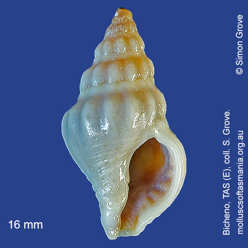
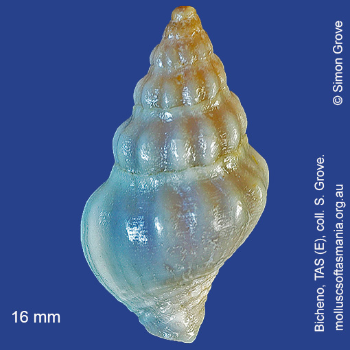
Buccinidae – Buccininae: Tasmeuthria clarkei (Tenison-Woods, 1876) (‘Clarke’s whelk’)
Synonym(s): clarkei Tenison-Woods, 1876 turrita Tenison-Woods, 1876.
Typical shell-length 20 mm. Lives subtidally amongst rocks and seaweed. Native. Endemic to southeastern Australia (TAS, VIC and SA). In Tasmanian waters, this is a widespread but uncommon species.
Classification
Class: Gastropoda
Subclass: Caenogastropoda – Sorbeoconcha
Order: Hypsogastropoda – Neogastropoda
Superfamily: Buccinoidea
Family: Buccinidae
Subfamily: Buccininae
Genus: Tasmeuthria
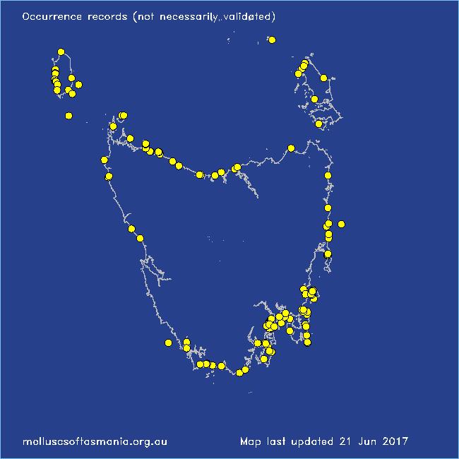
Localities for Tasmeuthria clarkei
Arthur River: Nelson Bay
Arthur River: Sarah Anne Rocks
Bangor: Lagoon Bay
Bicheno: Courland Bay
Bicheno: Rice Beach
Blackman Bay: Little Chinaman Bay
Blackmans Bay
Black River Beach: northern end
Carlton Beach: Spectacle Island
Chain of Lagoons: Four Mile Creek: beach
Clarke Island: Dip Point to Black Rocks
Clifton Beach: western end
Coles Bay: foreshore
Coles Bay: Honeymoon Bay
Coles Bay: Parsons Cove
Cox Bight (unlocalised)
Davey River: Carvers Point
Deadmans Bay
Denison Beach: Porch Rocks
Eaglehawk Neck: eastern side
East Devonport: Pardoe Point
Flinders Island: Fotheringate Bay
Flinders Island: Killiecrankie: foreshore
Flinders Island: Leeka: foreshore towards Twelve Hour Point
Flinders Island: Palana Beach
Flinders Island: Patriarch Inlet
Flinders Island: The Dock
Fortescue Bay
Granville Harbour
Greens Beach: main beach
Hawley Beach: foreshore towards Point Sorell
Hunter Island (unlocalised)
King Island: British Admiral Beach
King Island: Cape Wickham: foreshore to E
King Island: Currie Harbour
King Island: Ettrick Beach
King Island: Fitzmaurice Bay
King Island: Grassy Harbour
King Island: Halfmoon Bay
King Island: Little Porky Beach
King Island: Naracoopa: foreshore
King Island: Pass River Bay
King Island: Porky Beach
King Island: Seal Bay: Black Point
King Island (unlocalised)
King Island: W coast
Lauderdale: Roches Beach
Lime Bay: Green Head
Louisa Bay
Low Head (unlocalised)
Margate: Dru Point & Nierinna Creek mouth
Maria Island: Darlington Bay
Maria Island: Gulls Nest Point
Maria Island: Howells Point & Painted Cliffs
Maria Island: Return Point
Maria Island: Trigonia Corner
Marion Bay: Bream Creek foreshore
Marrawah: West Point
New Harbour
North Bruny Island: Dennes Point
Nubeena: Roaring Beach
Orford: East Shelly Beach
Orford: Spring Beach
Pirates Bay: Fossil Island
Planters Beach to Fishers Point
Port Davey: Whalers Cove
Port Latta: Cowrie Point
Randalls Bay
Rheban Beach
Robbins Island: Marys Island area
Rocky Cape: Burgess Cove
Rocky Cape: Castle Rock Bay
Rocky Cape: Mary Anne Cove area
Seymour Beach: northern end
Somerset: foreshore
South Arm: Fort Beach
South Bruny Island: Adventure Bay: Cemetery Bluff
South Bruny Island: Adventure Bay: Grass Point
South Bruny Island: Cloudy Beaches: eastern beach
South coast of Tasmania (unlocalised)
South East coast of Tasmania (unlocalised)
Stanley: foreshore
Stanley: Godfreys Beach
Taroona: Alum Cliffs
Taroona Beach
Taroona: Dixons Beach
Taroona: Hinsby Beach
Tasmania (unlocalised)
The Gardens: Mateys Gulch to Gardens Lagoon
Three Hummock Island: Mermaid Bay
Three Hummock Island: Rape Bay
Tinderbox Beach
Trial Harbour
Trial Harbour area
Ulverstone (unlocalised)
Waterhouse Point
West Ulverstone: foreshore
Wynyard: Fossil Bluff