Sorell: Orielton Lagoon Geographic information This coastal locality is at latitude 42.7849 S, longitude 147.5395 E. Species recorded from this locality The image thumbnails below show the species for which there are records from this coastal locality....
Sorell: Woody Island Geographic information This coastal locality is at latitude 42.8125 S, longitude 147.5605 E. Species recorded from this locality The image thumbnails below show the species for which there are records from this coastal locality. Note...
South Arm Neck: northern side Geographic information This coastal locality is at latitude 43.0318 S, longitude 147.4549 E. Species recorded from this locality The image thumbnails below show the species for which there are records from this coastal...
South Arm: beach Geographic information This coastal locality is at latitude 43.0220 S, longitude 147.4159 E. Species recorded from this locality The image thumbnails below show the species for which there are records from this coastal locality. Note...
South Arm: Calverts Lagoon Geographic information This coastal locality is at latitude 43.0203 S, longitude 147.4922 E. Species recorded from this locality The image thumbnails below show the species for which there are records from this coastal...
South Arm: Fort Beach Geographic information This coastal locality is at latitude 43.0378 S, longitude 147.4076 E. Species recorded from this locality The image thumbnails below show the species for which there are records from this coastal locality....
South Arm: Hope Beach: southern end Geographic information This coastal locality is at latitude 43.0341 S, longitude 147.4553 E. Species recorded from this locality The image thumbnails below show the species for which there are records from this coastal...
South Arm: Mary Ann Beach & Gellibrand Point Geographic information This coastal locality is at latitude 42.9646 S, longitude 147.4048 E. Species recorded from this locality The image thumbnails below show the species for which there are records from...
South Arm: Opossum Bay Geographic information This coastal locality is at latitude 42.9922 S, longitude 147.4034 E. Species recorded from this locality The image thumbnails below show the species for which there are records from this coastal locality....
South Arm: Pigeon Holes Geographic information This coastal locality is at latitude 43.0075 S, longitude 147.4011 E. Species recorded from this locality The image thumbnails below show the species for which there are records from this coastal locality....
South Bruny Island (unlocalised) Geographic information This coastal locality is at latitude 43.3677 S, longitude 147.3500 E. Species recorded from this locality The image thumbnails below show the species for which there are records from this coastal...
South Bruny Island: Adventure Bay – Coal Point Geographic information This coastal locality is at latitude 43.3341 S, longitude 147.3249 E. Species recorded from this locality The image thumbnails below show the species for which there are records...
South Bruny Island: Adventure Bay (unlocalised) Geographic information This coastal locality is at latitude 43.3639 S, longitude 147.3332 E. Species recorded from this locality The image thumbnails below show the species for which there are records from...
South Bruny Island: Adventure Bay: Cemetery Bluff Geographic information This coastal locality is at latitude 43.3398 S, longitude 147.3240 E. Species recorded from this locality The image thumbnails below show the species for which there are records...
South Bruny Island: Adventure Bay: East Cove Geographic information This coastal locality is at latitude 43.3634 S, longitude 147.3564 E. Species recorded from this locality The image thumbnails below show the species for which there are records from...
South Bruny Island: Adventure Bay: Grass Point Geographic information This coastal locality is at latitude 43.3504 S, longitude 147.3678 E. Species recorded from this locality The image thumbnails below show the species for which there are records from...
South Bruny Island: Adventure Bay: northern end Geographic information This coastal locality is at latitude 43.3480 S, longitude 147.3234 E. Species recorded from this locality The image thumbnails below show the species for which there are records from...
South Bruny Island: Adventure Bay: southern end Geographic information This coastal locality is at latitude 43.3677 S, longitude 147.3500 E. Species recorded from this locality The image thumbnails below show the species for which there are records from...
South Bruny Island: Adventure Bay: Two Tree Point Geographic information This coastal locality is at latitude 43.3483 S, longitude 147.3232 E. Species recorded from this locality The image thumbnails below show the species for which there are records...
South Bruny Island: Alonnah Beach Geographic information This coastal locality is at latitude 43.3146 S, longitude 147.2419 E. Species recorded from this locality The image thumbnails below show the species for which there are records from this coastal...
South Bruny Island: Alonnah: Sunset Bay Geographic information This coastal locality is at latitude 43.3241 S, longitude 147.2406 E. Species recorded from this locality The image thumbnails below show the species for which there are records from this...
South Bruny Island: Bay of Islands Geographic information This coastal locality is at latitude 43.4055 S, longitude 147.3491 E. Species recorded from this locality The image thumbnails below show the species for which there are records from this coastal...
South Bruny Island: Beaufort Bay Geographic information This coastal locality is at latitude 43.4729 S, longitude 147.2468 E. Species recorded from this locality The image thumbnails below show the species for which there are records from this coastal...
South Bruny Island: Butlers Beach Geographic information This coastal locality is at latitude 43.4116 S, longitude 147.1060 E. Species recorded from this locality The image thumbnails below show the species for which there are records from this coastal...
South Bruny Island: Cloudy Bay Lagoon Geographic information This coastal locality is at latitude 43.4318 S, longitude 147.2178 E. Species recorded from this locality The image thumbnails below show the species for which there are records from this...
South Bruny Island: Cloudy Beaches: eastern beach Geographic information This coastal locality is at latitude 43.4392 S, longitude 147.2367 E. Species recorded from this locality The image thumbnails below show the species for which there are records...
South Bruny Island: Cloudy Beaches: western beach Geographic information This coastal locality is at latitude 43.4373 S, longitude 147.2084 E. Species recorded from this locality The image thumbnails below show the species for which there are records...
South Bruny Island: Coal Point Geographic information This coastal locality is at latitude 43.3336 S, longitude 147.3251 E. Species recorded from this locality The image thumbnails below show the species for which there are records from this coastal...
South Bruny Island: Great Taylors Bay Geographic information This coastal locality is at latitude 43.4589 S, longitude 147.1546 E. Species recorded from this locality The image thumbnails below show the species for which there are records from this...
South Bruny Island: Hen & Chickens Rocks: foreshore to E Geographic information This coastal locality is at latitude 43.4367 S, longitude 147.1129 E. Species recorded from this locality The image thumbnails below show the species for which there are...
South Bruny Island: Hopwood Beach Geographic information This coastal locality is at latitude 43.4175 S, longitude 147.0984 E. Species recorded from this locality The image thumbnails below show the species for which there are records from this coastal...
South Bruny Island: Lighthouse Bay Geographic information This coastal locality is at latitude 43.4875 S, longitude 147.1460 E. Species recorded from this locality The image thumbnails below show the species for which there are records from this coastal...
South Bruny Island: Little Taylors Bay Geographic information This coastal locality is at latitude 43.3823 S, longitude 147.2115 E. Species recorded from this locality The image thumbnails below show the species for which there are records from this...
South Bruny Island: Lunawanna: Cemetery Beach Geographic information This coastal locality is at latitude 43.3485 S, longitude 147.2252 E. Species recorded from this locality The image thumbnails below show the species for which there are records from...
South Bruny Island: Lunawanna: Daniels Bay Geographic information This coastal locality is at latitude 43.3637 S, longitude 147.2340 E. Species recorded from this locality The image thumbnails below show the species for which there are records from this...
South Bruny Island: Mickeys Bay Geographic information This coastal locality is at latitude 43.4293 S, longitude 147.1920 E. Species recorded from this locality The image thumbnails below show the species for which there are records from this coastal...
South Bruny Island: Neck Beach: Blighs Rocks Geographic information This coastal locality is at latitude 43.3130 S, longitude 147.3219 E. Species recorded from this locality The image thumbnails below show the species for which there are records from...
South Bruny Island: Old Jetty Beach Geographic information This coastal locality is at latitude 43.4632 S, longitude 147.1620 E. Species recorded from this locality The image thumbnails below show the species for which there are records from this coastal...
South Bruny Island: Old Jetty Beach: beaches to N Geographic information This coastal locality is at latitude 43.4499 S, longitude 147.1469 E. Species recorded from this locality The image thumbnails below show the species for which there are records...
South Bruny Island: Quarries Bay Geographic information This coastal locality is at latitude 43.4122 S, longitude 147.1024 E. Species recorded from this locality The image thumbnails below show the species for which there are records from this coastal...
South Bruny Island: Quarries Bay Geographic information This coastal locality is at latitude 43.3560 S, longitude 147.1850 E. Species recorded from this locality The image thumbnails below show the species for which there are records from this coastal...
South Bruny Island: Quiet Corner Geographic information This coastal locality is at latitude 43.3549 S, longitude 147.3274 E. Species recorded from this locality The image thumbnails below show the species for which there are records from this coastal...
South Bruny Island: Sheepwash Bay Geographic information This coastal locality is at latitude 43.2918 S, longitude 147.2713 E. Species recorded from this locality The image thumbnails below show the species for which there are records from this coastal...
South Bruny Island: Simpsons Bay Geographic information This coastal locality is at latitude 43.2944 S, longitude 147.3121 E. Species recorded from this locality The image thumbnails below show the species for which there are records from this coastal...
South Bruny Island: Simpsons Bay: southern end Geographic information This coastal locality is at latitude 43.2964 S, longitude 147.3100 E. Species recorded from this locality The image thumbnails below show the species for which there are records from...
South Bruny Island: Simpsons Point Geographic information This coastal locality is at latitude 43.2410 S, longitude 147.2929 E. Species recorded from this locality The image thumbnails below show the species for which there are records from this coastal...
South Bruny Island: Tasman Head Geographic information This coastal locality is at latitude 43.5143 S, longitude 147.2956 E. Species recorded from this locality The image thumbnails below show the species for which there are records from this coastal...
South Burnie Geographic information This coastal locality is at latitude 41.0624 S, longitude 145.9162 E. Species recorded from this locality The image thumbnails below show the species for which there are records from this coastal locality. Note that...
South Cape Bay (unlocalised) Geographic information This coastal locality is at latitude 43.6110 S, longitude 146.8229 E. Species recorded from this locality The image thumbnails below show the species for which there are records from this coastal...
South Cape Bay: Lion Rock: beach to SE Geographic information This coastal locality is at latitude 43.6110 S, longitude 146.8229 E. Species recorded from this locality The image thumbnails below show the species for which there are records from this...
South Cape Rivulet: mouth Geographic information This coastal locality is at latitude 43.6006 S, longitude 146.7856 E. Species recorded from this locality The image thumbnails below show the species for which there are records from this coastal locality....
South coast of Tasmania (unlocalised) Geographic information This coastal locality is at latitude 43.6110 S, longitude 146.8229 E. Species recorded from this locality The image thumbnails below show the species for which there are records from this...
South Croppies Point Geographic information This coastal locality is at latitude 40.8640 S, longitude 147.5843 E. Species recorded from this locality The image thumbnails below show the species for which there are records from this coastal locality. Note...
South East coast of Tasmania (unlocalised) Geographic information This coastal locality is at latitude 42.9967 S, longitude 147.3200 E. Species recorded from this locality The image thumbnails below show the species for which there are records from this...
South West Cape Geographic information This coastal locality is at latitude 43.5710 S, longitude 146.0314 E. Species recorded from this locality The image thumbnails below show the species for which there are records from this coastal locality. Note that...
Southport Geographic information This coastal locality is at latitude 43.4320 S, longitude 146.9744 E. Species recorded from this locality The image thumbnails below show the species for which there are records from this coastal locality. Note that some...
Southport Bluff: beach Geographic information This coastal locality is at latitude 43.4805 S, longitude 146.9950 E. Species recorded from this locality The image thumbnails below show the species for which there are records from this coastal locality....
Southport Lagoon: northern end Geographic information This coastal locality is at latitude 43.4745 S, longitude 146.9821 E. Species recorded from this locality The image thumbnails below show the species for which there are records from this coastal...
Southport Lagoon: southern end Geographic information This coastal locality is at latitude 43.4924 S, longitude 146.9530 E. Species recorded from this locality The image thumbnails below show the species for which there are records from this coastal...
Southport: Big Lagoon Beach Geographic information This coastal locality is at latitude 43.5149 S, longitude 146.9532 E. Species recorded from this locality The image thumbnails below show the species for which there are records from this coastal...
Southport: Hythe Beach Geographic information This coastal locality is at latitude 43.4320 S, longitude 146.9744 E. Species recorded from this locality The image thumbnails below show the species for which there are records from this coastal locality....
Southport: Kingfish Beach Geographic information This coastal locality is at latitude 43.4358 S, longitude 146.9637 E. Species recorded from this locality The image thumbnails below show the species for which there are records from this coastal locality....
Southport: Roaring Beach Geographic information This coastal locality is at latitude 43.4352 S, longitude 146.9906 E. Species recorded from this locality The image thumbnails below show the species for which there are records from this coastal locality....
Southport: Sisters Bay Geographic information This coastal locality is at latitude 43.4213 S, longitude 147.0126 E. Species recorded from this locality The image thumbnails below show the species for which there are records from this coastal locality....
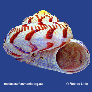
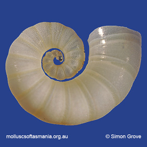
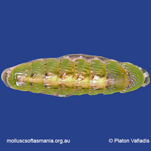
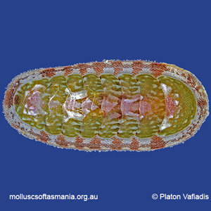
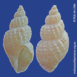
Solariellidae: Spectamen philippense (Watson, 1881) (‘Philip Island top-shell’) Synonym(s): philippense Watson, 1881. Typical shell-length 10 mm. Lives subtidally amongst rocks and seaweed. Native. Endemic to southeastern Australia (NSW, TAS and VIC)....
Cerithiopsidae – Cerithiopsinae: Specula regina Cotton, 1951 (‘queen false-creeper’) Synonym(s): regina Cotton, 1951. Typical shell-length 8.0 mm. Lives subtidally and offshore. Native. Endemic to southeastern and southwestern Australia (TAS, VIC, SA...
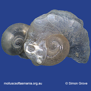
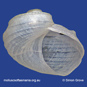
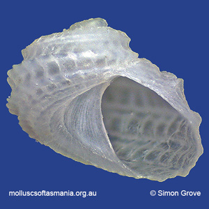
Spirulidae: Spirula spirula (Linnaeus, 1758) (‘common ramshorn-squid’) Synonym(s): spirula Linnaeus, 1758. Typical shell-length 23 mm. Living animal is a deep-water pelagic squid. Once dead, the animal’s chambered, gas-filled shell floats and may...
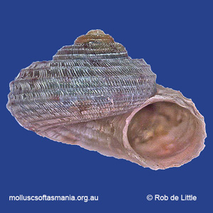
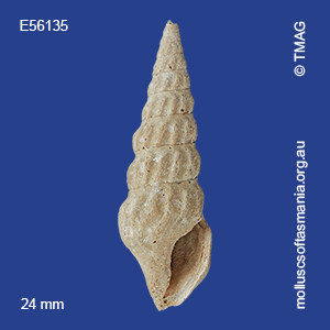
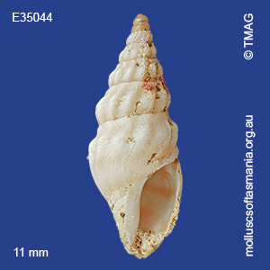
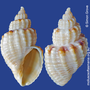
Drilliidae: Splendrillia (Splendrillia) gratiosa (G. B. Sowerby III, 1896) (‘agreeable turrid’) Synonym(s): gratiosa Sowerby, 1897. Typical shell-length 17 mm. Lives in offshore waters. Native. Endemic to southern Australia (TAS and SA). In Tasmanian...
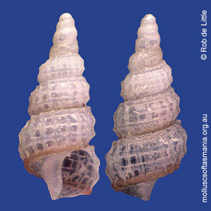
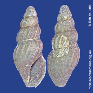
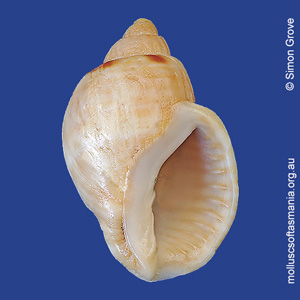
Drilliidae: Splendrillia (Splendrillia) subviridis (May, 1911) (‘greenish turrid’) Synonym(s): subviridis May, 1911. Typical shell-length 20 mm. Lives subtidally and offshore. Native. Endemic to southeastern Australia (TAS and VIC). Classification Class:...
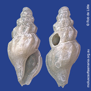
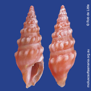
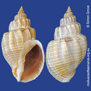
Drilliidae: Splendrillia TAS sp 01 (‘TAS sp 01 splendrillia turrid’) Synonym(s): TAS sp 01 Typical shell-length 6 mm. Lives subtidally and offshore. Native. Occurs in southeastern Australia (TAS and perhaps other states) Classification Class: Gastropoda...
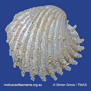
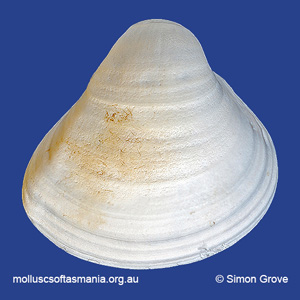
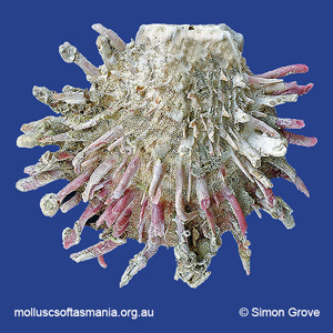
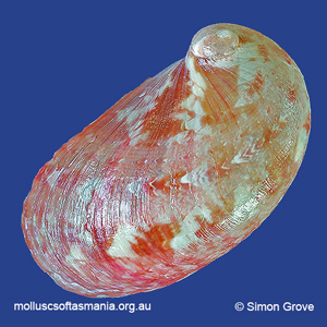
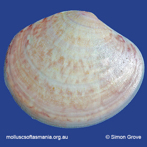
Spondylidae: Spondylus tenellus Reeve, 1856 (‘slender thorny-oyster’) Synonym(s): tenellus Reeve, 1856 regillus Iredale, 1929. Typical shell-length 100 mm. Most beached shells lack the long spines present on the shells of living animals. Lives subtidally...
Spring Bay Geographic information This coastal locality is at latitude 42.5307 S, longitude 147.9129 E. Species recorded from this locality The image thumbnails below show the species for which there are records from this coastal locality. Note that some...
St Helens Point Geographic information This coastal locality is at latitude 41.2753 S, longitude 148.3579 E. Species recorded from this locality The image thumbnails below show the species for which there are records from this coastal locality. Note that...
Stack Island Geographic information This coastal locality is at latitude 40.6080 S, longitude 144.7762 E. Species recorded from this locality The image thumbnails below show the species for which there are records from this coastal locality. Note that...
Stanley (unlocalised) Geographic information This coastal locality is at latitude 40.7646 S, longitude 145.2928 E. Species recorded from this locality The image thumbnails below show the species for which there are records from this coastal locality....
Stanley: Anthony Beach Geographic information This coastal locality is at latitude 40.8025 S, longitude 145.1640 E. Species recorded from this locality The image thumbnails below show the species for which there are records from this coastal locality....
Stanley: Cable Station beach Geographic information This coastal locality is at latitude 40.7463 S, longitude 145.2671 E. Species recorded from this locality The image thumbnails below show the species for which there are records from this coastal...
Stanley: Circular Head Geographic information This coastal locality is at latitude 40.7646 S, longitude 145.2928 E. Species recorded from this locality The image thumbnails below show the species for which there are records from this coastal locality....
Stanley: Cow Rock beach Geographic information This coastal locality is at latitude 40.7423 S, longitude 145.2970 E. Species recorded from this locality The image thumbnails below show the species for which there are records from this coastal locality....
Stanley: East Inlet Geographic information This coastal locality is at latitude 40.8090 S, longitude 145.2690 E. Species recorded from this locality The image thumbnails below show the species for which there are records from this coastal locality. Note...
Stanley: foreshore Geographic information This coastal locality is at latitude 40.7646 S, longitude 145.2928 E. Species recorded from this locality The image thumbnails below show the species for which there are records from this coastal locality. Note...
Stanley: Godfreys Beach Geographic information This coastal locality is at latitude 40.7523 S, longitude 145.2945 E. Species recorded from this locality The image thumbnails below show the species for which there are records from this coastal locality....
Stanley: Green Hills: West Inlet entrance Geographic information This coastal locality is at latitude 40.7899 S, longitude 145.2663 E. Species recorded from this locality The image thumbnails below show the species for which there are records from this...
Stanley: Halfmoon Bay Geographic information This coastal locality is at latitude 40.7292 S, longitude 145.2708 E. Species recorded from this locality The image thumbnails below show the species for which there are records from this coastal locality....
Stanley: Highfield Point Geographic information This coastal locality is at latitude 40.7360 S, longitude 145.2911 E. Species recorded from this locality The image thumbnails below show the species for which there are records from this coastal locality....
Stanley: Perkins Bay & West Inlet Geographic information This coastal locality is at latitude 40.7897 S, longitude 145.2666 E. Species recorded from this locality The image thumbnails below show the species for which there are records from this...
Stanley: Tatlows Beach Geographic information This coastal locality is at latitude 40.7663 S, longitude 145.2894 E. Species recorded from this locality The image thumbnails below show the species for which there are records from this coastal locality....
Stanley: West Inlet Geographic information This coastal locality is at latitude 40.8049 S, longitude 145.2585 E. Species recorded from this locality The image thumbnails below show the species for which there are records from this coastal locality. Note...
Stephens Bay Geographic information This coastal locality is at latitude 43.3846 S, longitude 145.9680 E. Species recorded from this locality The image thumbnails below show the species for which there are records from this coastal locality. Note that...
Eulimidae: Stilapex lactarius Iredale, 1925 (‘milky brittlestar-snail’) Synonym(s): lactarius Iredale, 1925. Typical shell-length 8.0 mm. Lives in offshore waters as an internal parasite of bristlestars. Native. Occurs in southeastern Australia (NSW, TAS...
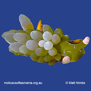
Limapontiidae: Stiliger smaragdinus Baba, 1949 (’emerald sea-slug’) Synonym(s): smaragdinus Baba, 1949. Typical body-length 50 mm. Lives intertidally and subtidally amongst seaweed, specifically various Caulerpa species with globular vesicles, on which it...
Storm Bay Geographic information This coastal locality is at latitude 43.0994 S, longitude 147.5407 E. Species recorded from this locality The image thumbnails below show the species for which there are records from this coastal locality. Note that some...
Storm Bay: around Wedge Island Geographic information This coastal locality is at latitude 43.1348 S, longitude 147.6640 E. Species recorded from this locality The image thumbnails below show the species for which there are records from this coastal...
Storm Bay: Betsey Island Geographic information This coastal locality is at latitude 43.0502 S, longitude 147.4861 E. Species recorded from this locality The image thumbnails below show the species for which there are records from this coastal locality....
Storm Bay: Iron Pot reef Geographic information This coastal locality is at latitude 43.0592 S, longitude 147.4175 E. Species recorded from this locality The image thumbnails below show the species for which there are records from this coastal locality....
Storm Bay: Trumpeter Bay: offshore Geographic information This coastal locality is at latitude 43.1578 S, longitude 147.3936 E. Species recorded from this locality The image thumbnails below show the species for which there are records from this coastal...
Strahan (unlocalised) Geographic information This coastal locality is at latitude 42.1569 S, longitude 145.3225 E. Species recorded from this locality The image thumbnails below show the species for which there are records from this coastal locality....
Strahan: Cape Sorell Geographic information This coastal locality is at latitude 42.1971 S, longitude 145.1700 E. Species recorded from this locality The image thumbnails below show the species for which there are records from this coastal locality. Note...
Strahan: Long Bay Geographic information This coastal locality is at latitude 42.1569 S, longitude 145.3225 E. Species recorded from this locality The image thumbnails below show the species for which there are records from this coastal locality. Note...
Strahan: Macquarie Heads Geographic information This coastal locality is at latitude 42.2184 S, longitude 145.2223 E. Species recorded from this locality The image thumbnails below show the species for which there are records from this coastal locality....
Strahan: Ocean Beach Geographic information This coastal locality is at latitude 42.1448 S, longitude 145.2636 E. Species recorded from this locality The image thumbnails below show the species for which there are records from this coastal locality. Note...
Strathblane: Esperance River Geographic information This coastal locality is at latitude 43.3258 S, longitude 146.9753 E. Species recorded from this locality The image thumbnails below show the species for which there are records from this coastal...
Stumpys Bay (unlocalised) Geographic information This coastal locality is at latitude 40.8680 S, longitude 148.2217 E. Species recorded from this locality The image thumbnails below show the species for which there are records from this coastal locality....
Surprise Bay Geographic information This coastal locality is at latitude 43.5825 S, longitude 146.6541 E. Species recorded from this locality The image thumbnails below show the species for which there are records from this coastal locality. Note that...
Surveyors Bay Geographic information This coastal locality is at latitude 43.2771 S, longitude 147.0887 E. Species recorded from this locality The image thumbnails below show the species for which there are records from this coastal locality. Note that...
Swansea (unlocalised) Geographic information This coastal locality is at latitude 42.1235 S, longitude 148.0763 E. Species recorded from this locality The image thumbnails below show the species for which there are records from this coastal locality....
Swansea: Coswell Beach Geographic information This coastal locality is at latitude 42.1479 S, longitude 148.0769 E. Species recorded from this locality The image thumbnails below show the species for which there are records from this coastal locality....
Swansea: Cressy Beach Geographic information This coastal locality is at latitude 42.1700 S, longitude 148.0784 E. Species recorded from this locality The image thumbnails below show the species for which there are records from this coastal locality....
Swansea: De Gillern Beach Geographic information This coastal locality is at latitude 42.2307 S, longitude 148.0216 E. Species recorded from this locality The image thumbnails below show the species for which there are records from this coastal locality....
Swansea: Jubilee Beach Geographic information This coastal locality is at latitude 42.1235 S, longitude 148.0763 E. Species recorded from this locality The image thumbnails below show the species for which there are records from this coastal locality....
Swansea: Kelvedon Beach Geographic information This coastal locality is at latitude 42.2004 S, longitude 148.0484 E. Species recorded from this locality The image thumbnails below show the species for which there are records from this coastal locality....
Swansea: Kelvedon Beach: Shelly Point Geographic information This coastal locality is at latitude 42.2081 S, longitude 148.0459 E. Species recorded from this locality The image thumbnails below show the species for which there are records from this...
Swansea: Kennedia Beach Geographic information This coastal locality is at latitude 42.1400 S, longitude 148.0777 E. Species recorded from this locality The image thumbnails below show the species for which there are records from this coastal locality....
Swansea: Lisdillon Beach Geographic information This coastal locality is at latitude 42.2873 S, longitude 148.0116 E. Species recorded from this locality The image thumbnails below show the species for which there are records from this coastal locality....
Swansea: Lisdillon Lagoon Geographic information This coastal locality is at latitude 42.2809 S, longitude 148.0017 E. Species recorded from this locality The image thumbnails below show the species for which there are records from this coastal locality....
Swansea: Maysons Bluff Geographic information This coastal locality is at latitude 42.1418 S, longitude 148.0803 E. Species recorded from this locality The image thumbnails below show the species for which there are records from this coastal locality....
Swansea: Meredith River: mouth Geographic information This coastal locality is at latitude 42.1159 S, longitude 148.0612 E. Species recorded from this locality The image thumbnails below show the species for which there are records from this coastal...
Swansea: Spiky Beach Geographic information This coastal locality is at latitude 42.1857 S, longitude 148.0684 E. Species recorded from this locality The image thumbnails below show the species for which there are records from this coastal locality. Note...
Swansea: Tirzah Beach Geographic information This coastal locality is at latitude 42.2273 S, longitude 148.0252 E. Species recorded from this locality The image thumbnails below show the species for which there are records from this coastal locality....
Swanwick: foreshore Geographic information This coastal locality is at latitude 42.1063 S, longitude 148.2436 E. Species recorded from this locality The image thumbnails below show the species for which there are records from this coastal locality. Note...
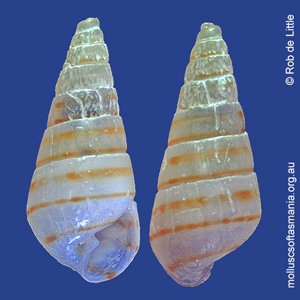
Pyramidellidae – Syrnolinae: Syrnola angusta Laseron, 1951 (‘slender pyramid-shell’) Synonym(s): angusta Laseron, 1951. Typical shell-length 9.0 mm. Lives subtidally as an ectoparasite of other invertebrates. Native. Endemic to southeastern Australia...
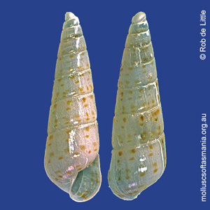
Pyramidellidae – Syrnolinae: Syrnola TAS sp 01 (‘TAS sp 01 pyramid-shell’) Synonym(s): TAS sp 01 Typical shell-length 3.0 mm. Lives in offshore waters as an ectoparasite of other invertebrates. Native. Occurs in southeastern Australia (TAS and...
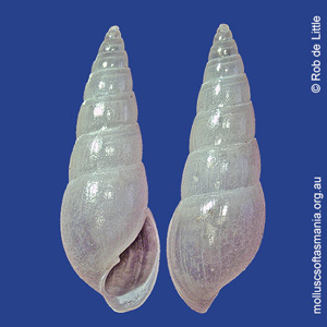
Pyramidellidae – Syrnolinae: Syrnola TAS sp 02 (‘TAS sp 02 pyramid-shell’) Synonym(s): (none available). Typical shell-length not yet determined. Lives in offshore waters. Native. Occurs in southeastern Australia (TAS and perhaps other states)....
Tamar Island Geographic information This coastal locality is at latitude 41.3808 S, longitude 147.0818 E. Species recorded from this locality The image thumbnails below show the species for which there are records from this coastal locality. Note that...
Tamar River: Batman Bridge Geographic information This coastal locality is at latitude 41.2180 S, longitude 146.9134 E. Species recorded from this locality The image thumbnails below show the species for which there are records from this coastal...
Tamar River: Beauty Point: Inspection Head area Geographic information This coastal locality is at latitude 41.1495 S, longitude 146.8225 E. Species recorded from this locality The image thumbnails below show the species for which there are records from...
Tamar River: Bell Bay (unlocalised) Geographic information This coastal locality is at latitude 41.1328 S, longitude 146.8702 E. Species recorded from this locality The image thumbnails below show the species for which there are records from this coastal...
Tamar River: Bell Bay: Big Bay Geographic information This coastal locality is at latitude 41.1438 S, longitude 146.9113 E. Species recorded from this locality The image thumbnails below show the species for which there are records from this coastal...
Tamar River: Bell Bay: Deceitful Cove Geographic information This coastal locality is at latitude 41.1304 S, longitude 146.8326 E. Species recorded from this locality The image thumbnails below show the species for which there are records from this...
Tamar River: Bell Bay: Donovans Bay Geographic information This coastal locality is at latitude 41.1380 S, longitude 146.9010 E. Species recorded from this locality The image thumbnails below show the species for which there are records from this coastal...
Tamar River: Bell Bay: Lawrences Bluff Geographic information This coastal locality is at latitude 41.1392 S, longitude 146.8439 E. Species recorded from this locality The image thumbnails below show the species for which there are records from this...
Tamar River: Bell Bay: Middle Island Geographic information This coastal locality is at latitude 41.1462 S, longitude 146.8648 E. Species recorded from this locality The image thumbnails below show the species for which there are records from this...
Tamar River: Bell Bay: power-station jetty Geographic information This coastal locality is at latitude 41.1434 S, longitude 146.9016 E. Species recorded from this locality The image thumbnails below show the species for which there are records from this...
Tamar River: Bell Bay: Sawyers Point Geographic information This coastal locality is at latitude 41.1381 S, longitude 146.8599 E. Species recorded from this locality The image thumbnails below show the species for which there are records from this...
Tamar River: Blackwall: foreshore Geographic information This coastal locality is at latitude 41.3041 S, longitude 146.9712 E. Species recorded from this locality The image thumbnails below show the species for which there are records from this coastal...
Tamar River: Brickmakers Point Geographic information This coastal locality is at latitude 41.2248 S, longitude 146.9237 E. Species recorded from this locality The image thumbnails below show the species for which there are records from this coastal...
Tamar River: channel entrance Geographic information This coastal locality is at latitude 41.1101 S, longitude 146.8094 E. Species recorded from this locality The image thumbnails below show the species for which there are records from this coastal...
Tamar River: Clarence Point: foreshore Geographic information This coastal locality is at latitude 41.1337 S, longitude 146.8122 E. Species recorded from this locality The image thumbnails below show the species for which there are records from this...
Tamar River: Cummings Creek: mouth Geographic information This coastal locality is at latitude 41.1762 S, longitude 146.9478 E. Species recorded from this locality The image thumbnails below show the species for which there are records from this coastal...
Tamar River: Devils Elbow Geographic information This coastal locality is at latitude 41.2005 S, longitude 146.8983 E. Species recorded from this locality The image thumbnails below show the species for which there are records from this coastal locality....
Tamar River: Dilston: foreshore Geographic information This coastal locality is at latitude 41.3311 S, longitude 147.0721 E. Species recorded from this locality The image thumbnails below show the species for which there are records from this coastal...
Tamar River: East Arm Geographic information This coastal locality is at latitude 41.1905 S, longitude 146.9645 E. Species recorded from this locality The image thumbnails below show the species for which there are records from this coastal locality....
Tamar River: Egg Island Point Geographic information This coastal locality is at latitude 41.2392 S, longitude 146.9688 E. Species recorded from this locality The image thumbnails below show the species for which there are records from this coastal...
Tamar River: Exeter: Stony Brook Geographic information This coastal locality is at latitude 41.2962 S, longitude 146.9681 E. Species recorded from this locality The image thumbnails below show the species for which there are records from this coastal...
Tamar River: Garden Island: shoal Geographic information This coastal locality is at latitude 41.1142 S, longitude 146.8140 E. Species recorded from this locality The image thumbnails below show the species for which there are records from this coastal...
Tamar River: George Town (unlocalised) Geographic information This coastal locality is at latitude 41.1113 S, longitude 146.8241 E. Species recorded from this locality The image thumbnails below show the species for which there are records from this...
Tamar River: George Town: foreshore Geographic information This coastal locality is at latitude 41.1113 S, longitude 146.8241 E. Species recorded from this locality The image thumbnails below show the species for which there are records from this coastal...
Tamar River: George Town: She Oak Point area Geographic information This coastal locality is at latitude 41.0800 S, longitude 146.8059 E. Species recorded from this locality The image thumbnails below show the species for which there are records from...
Tamar River: George Town: York Cove Geographic information This coastal locality is at latitude 41.1113 S, longitude 146.8241 E. Species recorded from this locality The image thumbnails below show the species for which there are records from this coastal...
Tamar River: Gravelly Beach Geographic information This coastal locality is at latitude 41.2944 S, longitude 146.9724 E. Species recorded from this locality The image thumbnails below show the species for which there are records from this coastal...
Tamar River: heads Geographic information This coastal locality is at latitude 41.0583 S, longitude 146.7894 E. Species recorded from this locality The image thumbnails below show the species for which there are records from this coastal locality. Note...
Tamar River: Hillwood: foreshore Geographic information This coastal locality is at latitude 41.2492 S, longitude 146.9899 E. Species recorded from this locality The image thumbnails below show the species for which there are records from this coastal...
Tamar River: Ilfraville: Redbill Point Geographic information This coastal locality is at latitude 41.1410 S, longitude 146.8063 E. Species recorded from this locality The image thumbnails below show the species for which there are records from this...
Tamar River: Ilfraville: Sandy Beach Geographic information This coastal locality is at latitude 41.1478 S, longitude 146.8190 E. Species recorded from this locality The image thumbnails below show the species for which there are records from this...
Tamar River: Kelso: foreshore Geographic information This coastal locality is at latitude 41.0999 S, longitude 146.7918 E. Species recorded from this locality The image thumbnails below show the species for which there are records from this coastal...
Tamar River: Kelso: Shear Reef Geographic information This coastal locality is at latitude 41.0809 S, longitude 146.7876 E. Species recorded from this locality The image thumbnails below show the species for which there are records from this coastal...
Tamar River: Launceston (unlocalised) Geographic information This coastal locality is at latitude 41.4341 S, longitude 147.1314 E. Species recorded from this locality The image thumbnails below show the species for which there are records from this...
Tamar River: Legana Beach Geographic information This coastal locality is at latitude 41.3398 S, longitude 147.0554 E. Species recorded from this locality The image thumbnails below show the species for which there are records from this coastal locality....
Tamar River: Legana: Freshwater Point Geographic information This coastal locality is at latitude 41.3459 S, longitude 147.0766 E. Species recorded from this locality The image thumbnails below show the species for which there are records from this...
Tamar River: Lone Pine Point Geographic information This coastal locality is at latitude 41.3410 S, longitude 147.0248 E. Species recorded from this locality The image thumbnails below show the species for which there are records from this coastal...
Tamar River: Long Reach Geographic information This coastal locality is at latitude 41.1610 S, longitude 146.9251 E. Species recorded from this locality The image thumbnails below show the species for which there are records from this coastal locality....
Tamar River: Long Reach: Williams Creek Geographic information This coastal locality is at latitude 41.1610 S, longitude 146.9251 E. Species recorded from this locality The image thumbnails below show the species for which there are records from this...
Tamar River: Marion’s Vineyard Geographic information This coastal locality is at latitude 41.2478 S, longitude 146.9387 E. Species recorded from this locality The image thumbnails below show the species for which there are records from this...
Tamar River: Masseys Creek mouth Geographic information This coastal locality is at latitude 41.1525 S, longitude 146.7664 E. Species recorded from this locality The image thumbnails below show the species for which there are records from this coastal...
Tamar River: Middle Arm Geographic information This coastal locality is at latitude 41.1806 S, longitude 146.8365 E. Species recorded from this locality The image thumbnails below show the species for which there are records from this coastal locality....
Tamar River: Middle Arm: Cobblestone Creek Geographic information This coastal locality is at latitude 41.1976 S, longitude 146.8384 E. Species recorded from this locality The image thumbnails below show the species for which there are records from this...
Tamar River: Middle Arm: Shag Head Geographic information This coastal locality is at latitude 41.1633 S, longitude 146.8355 E. Species recorded from this locality The image thumbnails below show the species for which there are records from this coastal...
Tamar River: Mowbray Point Geographic information This coastal locality is at latitude 41.2290 S, longitude 146.9454 E. Species recorded from this locality The image thumbnails below show the species for which there are records from this coastal...